District → Dhenkanal
State → Odisha
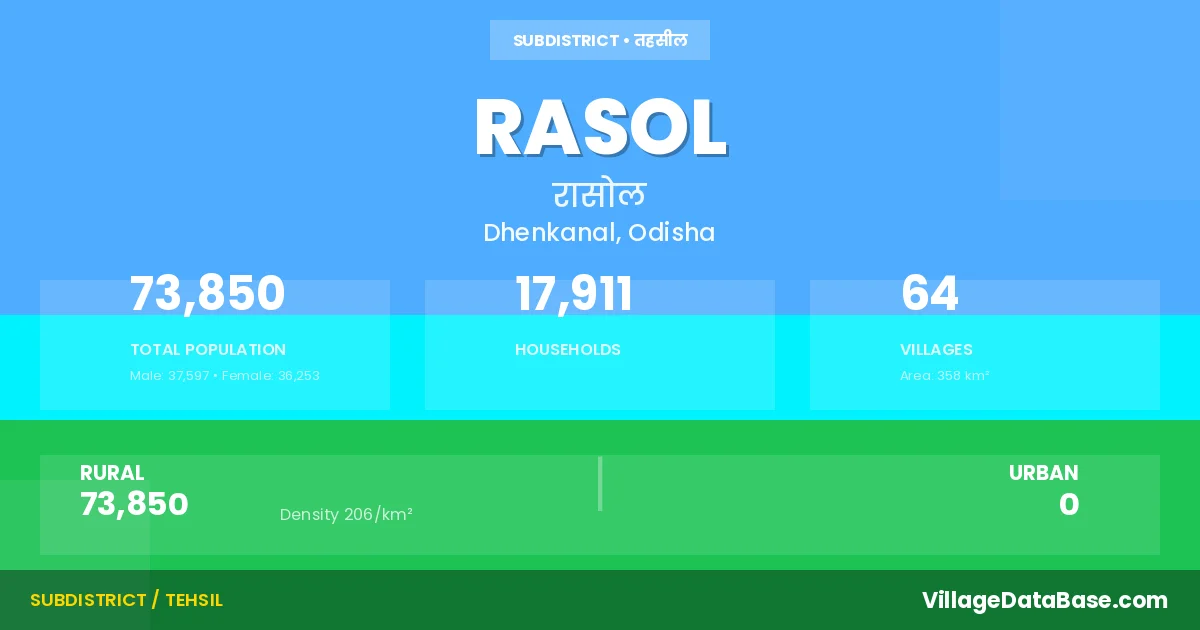
Rasol is a town and Tehsil in the Dhenkanal district of the Odisha. In India, a Tehsil is a subdivision of a district responsible for the administration and revenue collection of a specific area within the district. Tehsils play a crucial role in the local governance structure, contributing significantly to the development and administration of their communities.
According to the 2011 census The total area of Rasol Tehsil is 358 km², with a population of 73850 people. The population density is 206 inhabitants per square kilometre, and there are approximately 17911 houses in the sub district.
Rasol Tehsil comprises about 64 villages. Below is a list of these villages along with information about their respective gram panchayats and the nearest town:
| # | Village Name | Gram Panchayat | Nearest Town |
|---|---|---|---|
| 1 | Achutapur | Chitalpur | Dhenkanal (46 km) |
| 2 | Ambalundi | Jarada | Dhenkanal (42 km) |
| 3 | Anlabeda | Buhalipal | Dhenkanal (41 km) |
| 4 | Babandha | Babandha | Dhenkanal (28 km) |
| 5 | Badabahal | Giridhar Prasad | Dhenkanal (42 km) |
| 6 | Bahandei | Babandha | Dhenkanal (25 km) |
| 7 | Balikiari | Jarada | Dhenkanal (42 km) |
| 8 | Bampa | Bampa | Dhenkanal (35 km) |
| 9 | Bankitia | Buhalipal | Dhenkanal (40 km) |
| 10 | Basanta Pokhari | Giridhar Prasad | Dhenkanal (40 km) |
| 11 | Bedapada | Babandha | Dhenkanal (25 km) |
| 12 | Bhingira | Giridhar Prasad | Dhenkanal (40 km) |
| 13 | Bidyadharpur | Buhalipal | Dhenkanal (42 km) |
| 14 | Brahmaniapal | Bampa | Dhenkanal (35 km) |
| 15 | Brahmapur | Giridhar Prasad | Dhenkanal (39 km) |
| 16 | Buhalipal | Buhalipal | Dhenkanal (40 km) |
| 17 | Chilataila | Gandanali | Dhenkanal (26 km) |
| 18 | Chitalapur | Chitalpur | Dhenkanal (46 km) |
| 19 | Damodarpur | Kunua | Dhenkanal (37 km) |
| 20 | Dandiri | Dandiri | Dhenkanal (41 km) |
| 21 | Fasigan | Nabakishorepur | Dhenkanal (32 km) |
| 22 | Gandanali | Gandanali | Dhenkanal (30 km) |
| 23 | Ganjara | Bampa | Dhenkanal (23 km) |
| 24 | Ghodadian | Dandiri | Dhenkanal (47 km) |
| 25 | Giridharprasad | Giridhar Prasad | Dhenkanal (42 km) |
| 26 | Gobindapur | Khaliborei | Dhenkanal (40 km) |
| 27 | Guagaria | Kutunia | Dhenkanal (33 km) |
| 28 | Gulugundi | Kalinga | Dhenkanal (39 km) |
| 29 | Gurujanga | Dandiri | Dhenkanal (52 km) |
| 30 | Haripur | Jarada | Dhenkanal (40 km) |
| 31 | Hitinda | Nabakishorepur | Dhenkanal (40 km) |
| 32 | Iswarapal | Gandanali | Dhenkanal (26 km) |
| 33 | Jamuchakada | Kutunia | Dhenkanal (23 km) |
| 34 | Jarada | Jarada | Dhenkanal (42 km) |
| 35 | Kaduamada | Kutunia | Dhenkanal (24 km) |
| 36 | Kalinga | Kalinga | Dhenkanal (36 km) |
| 37 | Kalipoi | Nabakishorepur | Dhenkanal (35 km) |
| 38 | Kanaka | Dandiri | Dhenkanal (50 km) |
| 39 | Kapisahi | Nabakishorepur | Dhenkanal (30 km) |
| 40 | Karanda | Karanda | Dhenkanal (43 km) |
| 41 | Kathakumpa | Dandiri | Dhenkanal (45 km) |
| 42 | Khairabahali | Nabakishorepur | Dhenkanal (32 km) |
| 43 | Khaliborei | Khaliborei | Dhenkanal (40 km) |
| 44 | Khanditiri | Giridhar Prasad | Dhenkanal (39 km) |
| 45 | Kharachuli | Gandanali | Dhenkanal (25 km) |
| 46 | Kharidali | Kutunia | Dhenkanal (33 km) |
| 47 | Kunua | Kunua | Dhenkanal (37 km) |
| 48 | Kutunia | Kutunia | Dhenkanal (28 km) |
| 49 | Mardarajapur | Kunua | Dhenkanal (37 km) |
| 50 | Mohanapur | Bampa | Dhenkanal (30 km) |
| 51 | Nabakisorepur | Nabakishorepur | Dhenkanal (35 km) |
| 52 | Nahada | Dandiri | Dhenkanal (46 km) |
| 53 | Naukiari | Rasol | Dhenkanal (40 km) |
| 54 | Padhani | Kunua | Dhenkanal (37 km) |
| 55 | Palachakada | Kalinga | Dhenkanal (36 km) |
| 56 | Panchupada | Chitalpur | Dhenkanal (46 km) |
| 57 | Pasasinga | Buhalipal | Dhenkanal (42 km) |
| 58 | Patalu | Bampa | Dhenkanal (40 km) |
| 59 | Rajanga | Dandiri | Dhenkanal (46 km) |
| 60 | Ramachandrapur | Kunua | Dhenkanal (36 km) |
| 61 | Rasol | Rasol | Dhenkanal (41 km) |
| 62 | Santhilo | Giridhar Prasad | Dhenkanal (40 km) |
| 63 | Thenga | Jarada | Dhenkanal (42 km) |
| 64 | Uparapada | Bampa | Dhenkanal (52 km) |
The population is distributed between urban and rural areas as follows:
| Particulars | Rural | Urban | Total |
|---|---|---|---|
| Total Population | 73850 | 0 | 73850 |
| Male Population | 37597 | 0 | 37597 |
| Female Population | 36253 | 0 | 36253 | Population Density | 206 / km² | 206 / km² |
The distribution of households in the Rasol is:
| Rural Households | Urban Households | Total Households |
|---|---|---|
| 17911 | 0 | 17911 |
Q: What is Rasol?
A: Rasol is a town and in the Dhenkanal district of the Odisha.
Q: What is the total area of Rasol Tehsil?
A: The total area of Rasol Tehsil is 358 km².
Q: What is the population of Rasol Tehsil according to the 2011 census?
A: According to the 2011 census, the population of Rasol Tehsil is 73850.
Q: What is the population density of Rasol Tehsil?
A: The population density of Rasol Tehsil is 206 inhabitants per square kilometre.
Q: How many houses are there in Rasol Tehsil?
A: There are approximately 17911 houses in Rasol Tehsil.
Q: How many villages are there in Rasol Tehsil?
A: There are about 64 villages in Rasol Tehsil.
Q: Which is the largest village by population in Rasol Tehsil?
A: The largest village by population in Rasol Tehsil is Rasol, with 7598 people.
Q: Which is the smallest village by population in Rasol Tehsil?
A: The smallest village by population in Rasol Tehsil is Achutapur, with 0 people.
Q: Which is the largest village by area in Rasol Tehsil?
A: The largest village by area in Rasol Tehsil is Karanda, with 1952 km².
Q: Which is the smallest village by area in Rasol Tehsil?
A: The smallest village by area in Rasol Tehsil is Kathakumpa, with 0 km².
Q: What is the population distribution between urban and rural areas in Rasol Tehsil?
A: The population distribution in Rasol Tehsil is entirely rural, with a total rural population of 73850.
Q: What is the male population of Rasol Tehsil?
A: The male population of Rasol Tehsil is 37597.
Q: What is the female population of Rasol Tehsil?
A: The female population of Rasol Tehsil is 36253.
Q: How is the household distribution in Rasol Tehsil?
A: The household distribution in Rasol Tehsil is entirely rural, with a total of 17911 households.
Q: How many villages in Rasol Tehsil have a population of less than 100?
A: There are 7 villages in Rasol Tehsil with a population of less than 100.
Q: How many villages in Rasol Tehsil have a population between 100 and 499?
A: There are 21 villages in Rasol Tehsil with a population between 100 and 499.
Q: How many villages in Rasol Tehsil have a population between 500 and 999?
A: There are 12 villages in Rasol Tehsil with a population between 500 and 999.
Q: How many villages in Rasol Tehsil have a population between 1000 and 1999?
A: There are 12 villages in Rasol Tehsil with a population between 1000 and 1999.
Q: How many villages in Rasol Tehsil have a population between 2000 and 2999?
A: There is 8 village in Rasol Tehsil with a population between 2000 and 2999.
Q: How many villages in Rasol Tehsil have a population between 3000 and 3999?
A: There is 2 village in Rasol Tehsil with a population between 3000 and 3999.
Q: How many villages in Rasol Tehsil have a population of 5000 and above?
A: There is 2 village in Rasol Tehsil with a population of 5000 and above.
| Total Population | Villages in Sub District Of Rasol |
|---|---|
| Less than 100 | 7 |
| 100-499 | 21 |
| 500-999 | 12 |
| 1000-1999 | 12 |
| 2000-2999 | 8 |
| 3000-3999 | 2 |
| 5000 And Above | 2 |