District → Ganjam
State → Odisha
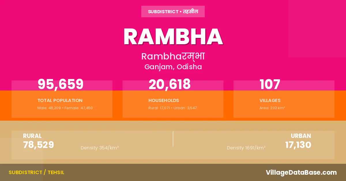
RAMBHA is a town and Tehsil in the Ganjam district of the Odisha. In India, a Tehsil is a subdivision of a district responsible for the administration and revenue collection of a specific area within the district. Tehsils play a crucial role in the local governance structure, contributing significantly to the development and administration of their communities.
According to the 2011 census The total area of RAMBHA Tehsil is 232 km², with a population of 95659 people. The population density is 413 inhabitants per square kilometre, and there are approximately 20618 houses in the sub district.
RAMBHA Tehsil comprises about 107 villages. Below is a list of these villages along with information about their respective gram panchayats and the nearest town:
| # | Village Name | Gram Panchayat | Nearest Town |
|---|---|---|---|
| 1 | Alandajhara | Sana Ramachandrapur | Rambha (5 km) |
| 2 | Ambathapalli | Kanaka | Rambha (5 km) |
| 3 | Ambillijhara | Palanga | Rambha (7 km) |
| 4 | Babala | Dimiria | Rambha (3 km) |
| 5 | Badachokada | Poirasi | Purusottampur (18 km) |
| 6 | Badagopalpur | Malada | Ganjam (8 km) |
| 7 | Badapalli | Dimiria | Rambha (5 km) |
| 8 | Badaramachandrapur | Poirasi | Purusottampur (12 km) |
| 9 | Badarampalli | Komonda | Purusottampur (15 km) |
| 10 | Badarampallikheta | Komonda | Khalikote (15 km) |
| 11 | Bagalpur | Khandadeuli | Purusottampur (20 km) |
| 12 | Bahadapalli | Subalaya | Rambha (4 km) |
| 13 | Balarampur | Khandadeuli | Purusottampur (20 km) |
| 14 | Balasinghapalli | Umuri Dharma Saranapur | Ganjam (22 km) |
| 15 | Balibagada | Subalaya | Chhatrapur (21 km) |
| 16 | Balinkisaranpur | Umuri Dharma Saranapur | Ganjam (17 km) |
| 17 | Balipur | Bania | Rambha (7 km) |
| 18 | Bandhatalanuagam | Ramagada | Chhatrapur (27 km) |
| 19 | Barapalli | Poirasi | Purusottampur (15 km) |
| 20 | Baurigandapalli | Sabulia | Rambha (4 km) |
| 21 | Belapada | Subalaya | Khalikote (20 km) |
| 22 | Benigohiri | Umuri Dharma Saranapur | Ganjam (23 km) |
| 23 | Bhaigadhia | Sana Ramachandrapur | Rambha (9 km) |
| 24 | Bhramarakudi | Ramagada | Ganjam (14 km) |
| 25 | Bhuanbhuin | Poirasi | Purusottampur (18 km) |
| 26 | Binayak Kahakapur | Palanga | Purusottampur (20 km) |
| 27 | Binchanapalli | Ramagada | Chhatrapur (24 km) |
| 28 | Birudigada | Sana Ramachandrapur | Rambha (15 km) |
| 29 | Borigam | Humma | Ganjam (8 km) |
| 30 | Chandrasekharpur | Poirasi | Purusottampur (12 km) |
| 31 | Chilikalake | Kesapur | Rambha (2 km) |
| 32 | Dadara Khola | Palanga | Rambha (9 km) |
| 33 | Diandein | Sana Ramachandrapur | Rambha (5 km) |
| 34 | Duburakudi | Ramagada | Chhatrapur (24 km) |
| 35 | Ganjamsalt Factory | Palibandha | Ganjam (8 km) |
| 36 | Govindapur | Sana Ramachandrapur | Rambha (5 km) |
| 37 | Gubudimardakote | Subalaya | Chhatrapur (25 km) |
| 38 | Gudijhara | Komonda | Khalikote (13 km) |
| 39 | Gunduripalli | Subalaya | Rambha (10 km) |
| 40 | Haripurburudi | Sana Ramachandrapur | Rambha (3 km) |
| 41 | Hata Nuagam | Malada | Ganjam (13 km) |
| 42 | Humma | Humma | Khalikote (20 km) |
| 43 | Jagannathapatna | Kanaka | Rambha (4 km) |
| 44 | Jahami | Sana Ramachandrapur | Rambha (3 km) |
| 45 | Jatiakhola | Palanga | Rambha (5 km) |
| 46 | Jayamangalhill | Ramagada | Ganjam (12 km) |
| 47 | Jharakana | Khandadeuli | Purusottampur (17 km) |
| 48 | Jharapalli | Badha Nalinakhapur | Purusottampur (15 km) |
| 49 | Jharidiradhagovindapur | Ramagada | Chhatrapur (24 km) |
| 50 | Kahakapur | Palanga | Rambha (8 km) |
| 51 | Kainchapur | Kainchapur | Purusottampur (12 km) |
| 52 | Kaithapalli | Poirasi | Rambha (5 km) |
| 53 | Kalapur | Ramagada | Khalikote (26 km) |
| 54 | Kaluabadia | Poirasi | Purusottampur (12 km) |
| 55 | Kanakhai | Palanga | Rambha (2 km) |
| 56 | Kantapadamathamukundpur | Subalaya | Chhatrapur (22 km) |
| 57 | Kanthiapalli | Poirasi | Purusottampur (16 km) |
| 58 | Kantiagada | Palibandha | Ganjam (12 km) |
| 59 | Kartikadhi | Santoshpur | Ganjam (14 km) |
| 60 | Kathagada | Malada | Ganjam (11 km) |
| 61 | Khandadeuli | Khandadeuli | Purusottampur (16 km) |
| 62 | Khandadiuli | Khandadeuli | Rambha (15 km) |
| 63 | Kharinihill | Komonda | Khalikote (13 km) |
| 64 | Kiajhara | Humma | Ganjam (11 km) |
| 65 | Kujidhipa | Santoshpur | Ganjam (14 km) |
| 66 | Kumanda | Komonda | Khalikote (15 km) |
| 67 | Kumaradapalli | Santoshpur | Ganjam (13 km) |
| 68 | Kusapalli | Malada | Ganjam (7 km) |
| 69 | Lauput | Santoshpur | Ganjam (14 km) |
| 70 | Laxmanpurbhimpur | Ramagada | Chhatrapur (24 km) |
| 71 | Lunguri | Malada | Ganjam (8 km) |
| 72 | Madhuruchua | Sana Ramachandrapur | Rambha (9 km) |
| 73 | Madhusudanpur | Ramagada | Brahmapur (27 km) |
| 74 | Mayurapada | Palibandha | Ganjam (11 km) |
| 75 | Medipur | Bania | Khalikote (13 km) |
| 76 | Mentapada | Khandadeuli | Rambha (5 km) |
| 77 | Mukundapur | Komonda | Khalikote (18 km) |
| 78 | Nalabenta | Sana Ramachandrapur | Rambha (5 km) |
| 79 | Nandanapalli | Umuri Dharma Saranapur | Ganjam (18 km) |
| 80 | Nimasula | Palanga | Rambha (5 km) |
| 81 | Nuagambarapalli | Ramagada | Chhatrapur (17 km) |
| 82 | Nuapalli | Poirasi | Khalikote (12 km) |
| 83 | Padagadajhatipadar | Ramagada | Chhatrapur (16 km) |
| 84 | Padukhai | Sana Ramachandrapur | Rambha (3 km) |
| 85 | Palanga | Palanga | Rambha (9 km) |
| 86 | Palurgada | Ramagada | Rambha |
| 87 | Panasadhiha | Sana Ramachandrapur | Rambha (5 km) |
| 88 | Panibandha | Malada | Ganjam (7 km) |
| 89 | Patapur | Khandadeuli | Rambha (10 km) |
| 90 | Patrapur | Komonda | Khalikote (19 km) |
| 91 | Phulajhara | Palanga | Rambha (6 km) |
| 92 | Poirasi | Poirasi | Purusottampur (12 km) |
| 93 | Pokharibari | Santoshpur | Ganjam (14 km) |
| 94 | Prayagi | Ramagada | Brahmapur (26 km) |
| 95 | Raghunathapur | Ramagada | Khalikote (10 km) |
| 96 | Raghunathpur | Badha Nalinakhapur | Chhatrapur (23 km) |
| 97 | Ranibara | Palanga | Rambha (3 km) |
| 98 | Sabilia | Subalaya | Rambha (2 km) |
| 99 | Sanagopalapur | Santoshpur | Ganjam (13 km) |
| 100 | Sanaramchandrapur | Sana Ramachandrapur | Rambha (2 km) |
| 101 | Santoshpur | Santoshpur | Ganjam (13 km) |
| 102 | Satrusola | Subalaya | Khalikote (21 km) |
| 103 | Satuli | Santoshpur | Rambha (10 km) |
| 104 | Sipakuda | Ramagada | Chhatrapur (24 km) |
| 105 | Subalaya | Sabulia | Chhatrapur (19 km) |
| 106 | Sunakera | Palanga | Rambha (4 km) |
| 107 | Tarenipalli | Poirasi | Purusottampur (12 km) |
The population is distributed between urban and rural areas as follows:
| Particulars | Rural | Urban | Total |
|---|---|---|---|
| Total Population | 78529 | 17130 | 95659 |
| Male Population | 39603 | 8606 | 48209 |
| Female Population | 38926 | 8524 | 47450 | Population Density | 354 / km² | 1691 / km² | 413 / km² |
The distribution of households in the RAMBHA is:
| Rural Households | Urban Households | Total Households |
|---|---|---|
| 17071 | 3547 | 20618 |
Q: What is RAMBHA?
A: RAMBHA is a town and in the Ganjam district of the Odisha.
Q: What is the total area of RAMBHA Tehsil?
A: The total area of RAMBHA Tehsil is 232 km².
Q: What is the population of RAMBHA Tehsil according to the 2011 census?
A: According to the 2011 census, the population of RAMBHA Tehsil is 95659.
Q: What is the population density of RAMBHA Tehsil?
A: The population density of RAMBHA Tehsil is 413 inhabitants per square kilometre.
Q: How many houses are there in RAMBHA Tehsil?
A: There are approximately 20618 houses in RAMBHA Tehsil.
Q: How many villages are there in RAMBHA Tehsil?
A: There are about 107 villages in RAMBHA Tehsil.
Q: Which is the largest village by population in RAMBHA Tehsil?
A: The largest village by population in RAMBHA Tehsil is Sabilia, with 6492 people.
Q: Which is the smallest village by population in RAMBHA Tehsil?
A: The smallest village by population in RAMBHA Tehsil is Alandajhara, with 0 people.
Q: Which is the largest village by area in RAMBHA Tehsil?
A: The largest village by area in RAMBHA Tehsil is Ranibara, with 1618 km².
Q: Which is the smallest village by area in RAMBHA Tehsil?
A: The smallest village by area in RAMBHA Tehsil is Ganjamsalt Factory, with 0 km².
Q: What is the male population of RAMBHA Tehsil?
A: The male population of RAMBHA Tehsil is 48209.
Q: What is the female population of RAMBHA Tehsil?
A: The female population of RAMBHA Tehsil is 47450.
Q: How many villages in RAMBHA Tehsil have a population of less than 100?
A: There are 27 villages in RAMBHA Tehsil with a population of less than 100.
Q: How many villages in RAMBHA Tehsil have a population between 100 and 499?
A: There are 29 villages in RAMBHA Tehsil with a population between 100 and 499.
Q: How many villages in RAMBHA Tehsil have a population between 500 and 999?
A: There are 25 villages in RAMBHA Tehsil with a population between 500 and 999.
Q: How many villages in RAMBHA Tehsil have a population between 1000 and 1999?
A: There are 18 villages in RAMBHA Tehsil with a population between 1000 and 1999.
Q: How many villages in RAMBHA Tehsil have a population between 2000 and 2999?
A: There is 5 village in RAMBHA Tehsil with a population between 2000 and 2999.
Q: How many villages in RAMBHA Tehsil have a population between 3000 and 3999?
A: There is 1 village in RAMBHA Tehsil with a population between 3000 and 3999.
Q: How many villages in RAMBHA Tehsil have a population of 5000 and above?
A: There is 2 village in RAMBHA Tehsil with a population of 5000 and above.
| Total Population | Villages in Sub District Of RAMBHA |
|---|---|
| Less than 100 | 27 |
| 100-499 | 29 |
| 500-999 | 25 |
| 1000-1999 | 18 |
| 2000-2999 | 5 |
| 3000-3999 | 1 |
| 5000 And Above | 2 |