Kanjipani: A Town and Tehsil in Kendujhar district
District → Kendujhar
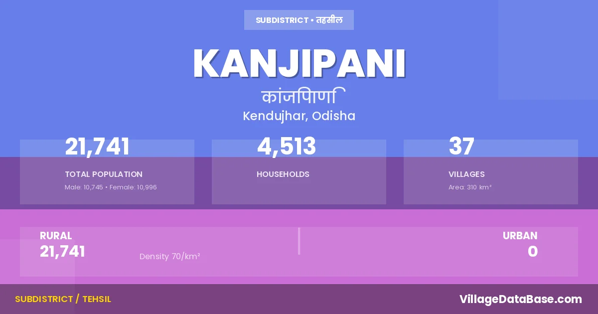
State → Odisha
Kanjipani is a town and Tehsil in the Kendujhar district of the Odisha. In India, a Tehsil is a subdivision of a district responsible for the administration and revenue collection of a specific area within the district. Tehsils play a crucial role in the local governance structure, contributing significantly to the development and administration of their communities.
According to the 2011 census The total area of Kanjipani Tehsil is 310 km², with a population of 21741 people. The population density is 70 inhabitants per square kilometre, and there are approximately 4513 houses in the sub district.
Kanjipani Tehsil comprises about 37 villages. Below is a list of these villages along with information about their respective gram panchayats and the nearest town:
| # | Village Name | Gram Panchayat | Nearest Town |
|---|---|---|---|
| 1 | Anasuan | Karangadihi | Kendujhar (25 km) |
| 2 | Baitarani | Gonasika | Kendujhar (25 km) |
| 3 | Bali | Baragarh | Kendujhar (35 km) |
| 4 | Benidihi | Tana | Kendujhar (45 km) |
| 5 | Budhighar | Gonasika | Kendujhar (33 km) |
| 6 | Emiri | Tana | Kendujhar (62 km) |
| 7 | Erida | Tana | Kendujhar (65 km) |
| 8 | Fulabadi | Baragarh | Kendujhar (45 km) |
| 9 | Gobindapur | Tana | Kendujhar (60 km) |
| 10 | Goliabandharaidiha | Gonasika | Kendujhar (30 km) |
| 11 | Gonasika | Gonasika | Kendujhar (30 km) |
| 12 | Guptaganga | Gonasika | Kendujhar (25 km) |
| 13 | Haladipani | Kuanr | Kendujhar (38 km) |
| 14 | Jamudiha | Baragarh | Kendujhar (46 km) |
| 15 | Jantari | Gonasika | Kendujhar (30 km) |
| 16 | Kadalibadi | Gonasika | Kendujhar (30 km) |
| 17 | Kaliapani | Oriyabirida | Kendujhar (70 km) |
| 18 | Kanjipani | Kuanr | Kendujhar (28 km) |
| 19 | Kanthadas | Bayakumutia | Kendujhar (33 km) |
| 20 | Karangadihi | Karangadihi | Kendujhar (33 km) |
| 21 | Kuanar | Kuanr | Kendujhar (26 km) |
| 22 | Lata | Karangadihi | Karanjia (7 km) |
| 23 | Lungajhar | Suakati | Kendujhar (35 km) |
| 24 | Mundatopa | Tana | Kendujhar (50 km) |
| 25 | Nipa | Kuanr | Kendujhar (32 km) |
| 26 | Padakasada | Saharpur | Kendujhar (20 km) |
| 27 | Panasanasa | Kuanr | Kendujhar (30 km) |
| 28 | Raidiha | Gonasika | Kendujhar (33 km) |
| 29 | Rugudikasada | Saharpur | Kendujhar (30 km) |
| 30 | Sapalanji | Oriyabirida | Kendujhar (40 km) |
| 31 | Sinkulapada | Gonasika | Kendujhar (35 km) |
| 32 | Talabaitarani | Kuanr | Kendujhar (30 km) |
| 33 | Talapada | Kuanr | Kendujhar (31 km) |
| 34 | Tamanga | Sibanarayanpurgoda | Kendujhar (38 km) |
| 35 | Tana | Tana | Kendujhar (20 km) |
| 36 | Tangarpada | Karangadihi | Kendujhar (33 km) |
| 37 | Tentulikhunti | Karangadihi | Kendujhar (32 km) |
The population is distributed between urban and rural areas as follows:
| Particulars | Rural | Urban | Total |
|---|---|---|---|
| Total Population | 21741 | 0 | 21741 |
| Male Population | 10745 | 0 | 10745 |
| Female Population | 10996 | 0 | 10996 | Population Density | 70 / km² | 70 / km² |
The distribution of households in the Kanjipani is:
| Rural Households | Urban Households | Total Households |
|---|---|---|
| 4513 | 0 | 4513 |
Q: What is Kanjipani?
A: Kanjipani is a town and in the Kendujhar district of the Odisha.
Q: What is the total area of Kanjipani Tehsil?
A: The total area of Kanjipani Tehsil is 310 km².
Q: What is the population of Kanjipani Tehsil according to the 2011 census?
A: According to the 2011 census, the population of Kanjipani Tehsil is 21741.
Q: What is the population density of Kanjipani Tehsil?
A: The population density of Kanjipani Tehsil is 70 inhabitants per square kilometre.
Q: How many houses are there in Kanjipani Tehsil?
A: There are approximately 4513 houses in Kanjipani Tehsil.
Q: How many villages are there in Kanjipani Tehsil?
A: There are about 37 villages in Kanjipani Tehsil.
Q: Which is the largest village by population in Kanjipani Tehsil?
A: The largest village by population in Kanjipani Tehsil is Kuanar, with 2136 people.
Q: Which is the smallest village by population in Kanjipani Tehsil?
A: The smallest village by population in Kanjipani Tehsil is Kaliapani, with 119 people.
Q: Which is the largest village by area in Kanjipani Tehsil?
A: The largest village by area in Kanjipani Tehsil is Kuanar, with 2654 km².
Q: Which is the smallest village by area in Kanjipani Tehsil?
A: The smallest village by area in Kanjipani Tehsil is Talabaitarani, with 72 km².
Q: What is the population distribution between urban and rural areas in Kanjipani Tehsil?
A: The population distribution in Kanjipani Tehsil is entirely rural, with a total rural population of 21741.
Q: What is the male population of Kanjipani Tehsil?
A: The male population of Kanjipani Tehsil is 10745.
Q: What is the female population of Kanjipani Tehsil?
A: The female population of Kanjipani Tehsil is 10996.
Q: How is the household distribution in Kanjipani Tehsil?
A: The household distribution in Kanjipani Tehsil is entirely rural, with a total of 4513 households.
Q: How many villages in Kanjipani Tehsil have a population between 100 and 499?
A: There are 21 villages in Kanjipani Tehsil with a population between 100 and 499.
Q: How many villages in Kanjipani Tehsil have a population between 500 and 999?
A: There are 12 villages in Kanjipani Tehsil with a population between 500 and 999.
Q: How many villages in Kanjipani Tehsil have a population between 1000 and 1999?
A: There are 3 villages in Kanjipani Tehsil with a population between 1000 and 1999.
Q: How many villages in Kanjipani Tehsil have a population between 2000 and 2999?
A: There is 1 village in Kanjipani Tehsil with a population between 2000 and 2999.
| Total Population | Villages in Sub District Of Kanjipani |
|---|---|
| 100-499 | 21 |
| 500-999 | 12 |
| 1000-1999 | 3 |
| 2000-2999 | 1 |