District → Khordha
State → Odisha
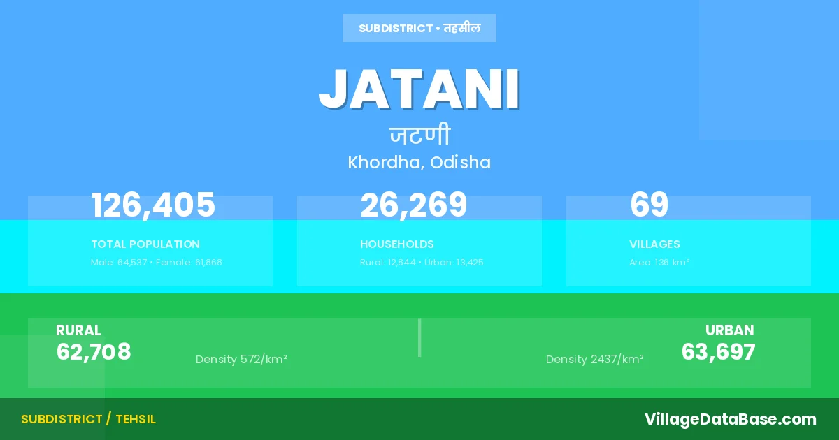
Jatani is a town and Tehsil in the Khordha district of the Odisha. In India, a Tehsil is a subdivision of a district responsible for the administration and revenue collection of a specific area within the district. Tehsils play a crucial role in the local governance structure, contributing significantly to the development and administration of their communities.
According to the 2011 census The total area of Jatani Tehsil is 136 km², with a population of 126405 people. The population density is 930 inhabitants per square kilometre, and there are approximately 26269 houses in the sub district.
Jatani Tehsil comprises about 69 villages. Below is a list of these villages along with information about their respective gram panchayats and the nearest town:
| # | Village Name | Gram Panchayat | Nearest Town |
|---|---|---|---|
| 1 | Alakar | Chhatabara | Jatani (7 km) |
| 2 | Ambaata | Benapanjari | Jatani (8 km) |
| 3 | Aragul | Haripur | Jatani (6 km) |
| 4 | Arisol | Chhatabara | Jatani (9 km) |
| 5 | Babaja | Haripur | Jatani (7 km) |
| 6 | Badaraghunathpur | Madanapur | Jatani (12 km) |
| 7 | Badatota | Padmapur | Jatani (3 km) |
| 8 | Bairang | Panchupalli | Jatani (8 km) |
| 9 | Belapada | Padmapur | Jatani (3 km) |
| 10 | Benapanjari | Benapanjari | Jatani (9 km) |
| 11 | Beruan | Panchupalli | Jatani (8 km) |
| 12 | Bhimapur | Padmapur | Jatani (5 km) |
| 13 | Bijipur | Benapanjari | Jatani (9 km) |
| 14 | Bisiapada | Benapanjari | Jatani (8 km) |
| 15 | Budhanagar | Benapanjari | Jatani (16 km) |
| 16 | Budhapada | Kantia | Jatani (5 km) |
| 17 | Chaitanyaprasad | Janla | Bhubaneswar (10 km) |
| 18 | Chandiheta | Janla | Jatani (8 km) |
| 19 | Chhelda | Chhanghara | Jatani (5 km) |
| 20 | Dakhinamundamuhan | Janla | Jatani (8 km) |
| 21 | Deulabasta | Haripur | Jatani (7 km) |
| 22 | Deuliapatna | Madanapur | Jatani (12 km) |
| 23 | Durgapur | Chhatabara | Jatani (9 km) |
| 24 | Gadajagasora | Madanapur | Jatani (13 km) |
| 25 | Gangapada | Gangapada | Khordha (6 km) |
| 26 | Gaudakashipur | Chhatabara | Jatani (7 km) |
| 27 | Gobindapur | Chhanghara | Jatani (5 km) |
| 28 | Gopalpur | Janla | Jatani (9 km) |
| 29 | Gopiballavapur | Benapanjari | Jatani (9 km) |
| 30 | Harapur | Chhatabara | Jatani (10 km) |
| 31 | Harekrushnapur | Chhatabara | Jatani (9 km) |
| 32 | Haridamada | Haripur | Jatani (6 km) |
| 33 | Haripur | Haripur | Jatani (8 km) |
| 34 | Industrial Colony Area | Jatani | |
| 35 | Jagasara | Madanapur | Jatani (14 km) |
| 36 | Jagasarapatna | Madanapur | Jatani (14 km) |
| 37 | Jagulaipadar | Chhanghara | Jatani (6 km) |
| 38 | Janla | Janla | Jatani (7 km) |
| 39 | Kaimatiabhoisahi | Madanapur | Jatani (15 km) |
| 40 | Kaimatiapatna | Madanapur | Jatani (15 km) |
| 41 | Kansapada | Haripur | Jatani (7 km) |
| 42 | Kantia | Kantia | Jatani (10 km) |
| 43 | Kholadwar | Padmapur | Jatani (3 km) |
| 44 | Khudupur | Padmapur | Jatani (6 km) |
| 45 | Koranga | Haripur | Jatani (7 km) |
| 46 | Madanpur | Madanapur | Jatani (14 km) |
| 47 | Mangarajpur | Haripur | Jatani (8 km) |
| 48 | Manipur | Haripur | Jatani (6 km) |
| 49 | Niranjanpur | Kantia | Jatani (12 km) |
| 50 | Ogalapada | Janla | Jatani (7 km) |
| 51 | Ogarsuan | Chhanghara | Jatani (4 km) |
| 52 | Padanpur | Padmapur | Jatani (5 km) |
| 53 | Pandiabili | Benapanjari | Jatani (9 km) |
| 54 | Paschimadwarpatana | Benapanjari | Jatani (8 km) |
| 55 | Patasahanipur | Janla | Jatani (7 km) |
| 56 | Pitapalli | Gangapada | Khordha (4 km) |
| 57 | Podapada | Haripur | Jatani (6 km) |
| 58 | Purusottampur | Benapanjari | Jatani (8 km) |
| 59 | Ranipur | Benapanjari | Jatani (8 km) |
| 60 | Rathipur | Kantia | Jatani (4 km) |
| 61 | Rayapurpatana | Benapanjari | Jatani (9 km) |
| 62 | Samapur | Haripur | Jatani (7 km) |
| 63 | Santarapur | Chhanghara | Jatani (8 km) |
| 64 | Sathuakera Gopalpur | Janla | Jatani (7 km) |
| 65 | Seulakhala | Benapanjari | Jatani (9 km) |
| 66 | Taraboi | Haripur | Jatani (7 km) |
| 67 | Trimal | Benapanjari | Jatani (8 km) |
| 68 | Uparbasta | Padmapur | Jatani (5 km) |
| 69 | Uttarmundamuhan | Janla | Jatani (8 km) |
The population is distributed between urban and rural areas as follows:
| Particulars | Rural | Urban | Total |
|---|---|---|---|
| Total Population | 62708 | 63697 | 126405 |
| Male Population | 31980 | 32557 | 64537 |
| Female Population | 30728 | 31140 | 61868 | Population Density | 572 / km² | 2437 / km² | 930 / km² |
The distribution of households in the Jatani is:
| Rural Households | Urban Households | Total Households |
|---|---|---|
| 12844 | 13425 | 26269 |
Q: What is Jatani?
A: Jatani is a town and in the Khordha district of the Odisha.
Q: What is the total area of Jatani Tehsil?
A: The total area of Jatani Tehsil is 136 km².
Q: What is the population of Jatani Tehsil according to the 2011 census?
A: According to the 2011 census, the population of Jatani Tehsil is 126405.
Q: What is the population density of Jatani Tehsil?
A: The population density of Jatani Tehsil is 930 inhabitants per square kilometre.
Q: How many houses are there in Jatani Tehsil?
A: There are approximately 26269 houses in Jatani Tehsil.
Q: How many villages are there in Jatani Tehsil?
A: There are about 69 villages in Jatani Tehsil.
Q: Which is the largest village by population in Jatani Tehsil?
A: The largest village by population in Jatani Tehsil is Trimal, with 3862 people.
Q: Which is the smallest village by population in Jatani Tehsil?
A: The smallest village by population in Jatani Tehsil is Ambaata, with 0 people.
Q: Which is the largest village by area in Jatani Tehsil?
A: The largest village by area in Jatani Tehsil is Kantia, with 586 km².
Q: Which is the smallest village by area in Jatani Tehsil?
A: The smallest village by area in Jatani Tehsil is Industrial Colony Area, with 0 km².
Q: What is the male population of Jatani Tehsil?
A: The male population of Jatani Tehsil is 64537.
Q: What is the female population of Jatani Tehsil?
A: The female population of Jatani Tehsil is 61868.
Q: How many villages in Jatani Tehsil have a population of less than 100?
A: There are 15 villages in Jatani Tehsil with a population of less than 100.
Q: How many villages in Jatani Tehsil have a population between 100 and 499?
A: There are 14 villages in Jatani Tehsil with a population between 100 and 499.
Q: How many villages in Jatani Tehsil have a population between 500 and 999?
A: There are 13 villages in Jatani Tehsil with a population between 500 and 999.
Q: How many villages in Jatani Tehsil have a population between 1000 and 1999?
A: There are 19 villages in Jatani Tehsil with a population between 1000 and 1999.
Q: How many villages in Jatani Tehsil have a population between 2000 and 2999?
A: There is 4 village in Jatani Tehsil with a population between 2000 and 2999.
Q: How many villages in Jatani Tehsil have a population between 3000 and 3999?
A: There is 4 village in Jatani Tehsil with a population between 3000 and 3999.
| Total Population | Villages in Sub District Of Jatani |
|---|---|
| Less than 100 | 15 |
| 100-499 | 14 |
| 500-999 | 13 |
| 1000-1999 | 19 |
| 2000-2999 | 4 |
| 3000-3999 | 4 |