Pottangi: A Town and Tehsil in Koraput district
District → Koraput
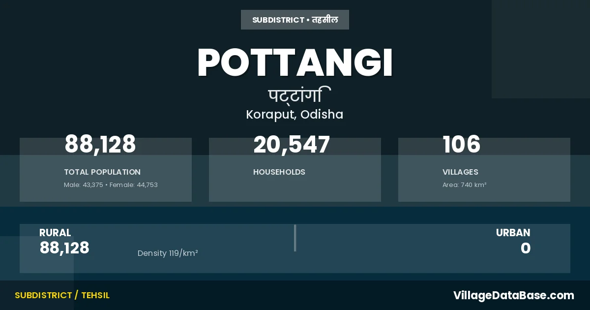
State → Odisha
Pottangi is a town and Tehsil in the Koraput district of the Odisha. In India, a Tehsil is a subdivision of a district responsible for the administration and revenue collection of a specific area within the district. Tehsils play a crucial role in the local governance structure, contributing significantly to the development and administration of their communities.
According to the 2011 census The total area of Pottangi Tehsil is 740 km², with a population of 88128 people. The population density is 119 inhabitants per square kilometre, and there are approximately 20547 houses in the sub district.
Pottangi Tehsil comprises about 106 villages. Below is a list of these villages along with information about their respective gram panchayats and the nearest town:
| # | Village Name | Gram Panchayat | Nearest Town |
|---|---|---|---|
| 1 | Alasi | Sunki | Jeypur (42 km) |
| 2 | Ampaballi | Ampavalli | Jeypur (61 km) |
| 3 | Bailiguda | Petteru | Jeypur (37 km) |
| 4 | Bandagudi | Talagoluru | Jeypur (56 km) |
| 5 | Bangarugudi | Talagoluru | Koraput (57 km) |
| 6 | Baraja | Chandaka | Jeypur (40 km) |
| 7 | Barakutni | Dudhari | Nabarangapur (13 km) |
| 8 | Bhitaraguda | Subai | Jeypur (32 km) |
| 9 | Bhitarkota | Sorispadar | Jeypur (47 km) |
| 10 | Bitra | Ralegada | Jeypur (30 km) |
| 11 | Bituguda | Pottangi | Jeypur (48 km) |
| 12 | Bodavalsa | Maliput | Jeypur (19 km) |
| 13 | Bodogolluru | Talagoluru | Jeypur (51 km) |
| 14 | Boriguda | Gunthaput | Jeypur (29 km) |
| 15 | Chandaka | Chandaka | Jeypur (36 km) |
| 16 | Dabagunta | Deopattangi | Jeypur (44 km) |
| 17 | Dalapatiguda | Chandaka | Jeypur (38 km) |
| 18 | Deopottangi | Deopattangi | Jeypur (42 km) |
| 19 | Deula | Hataguda | Kotpad (25 km) |
| 20 | Digugabadar | Nuagaon | Jeypur (23 km) |
| 21 | Dumuriguda | Deopattangi | Jeypur (31 km) |
| 22 | Epabalasa | Sunki | Jeypur (39 km) |
| 23 | Gangarajpur | Gangarajpur | Jeypur (16 km) |
| 24 | Giriliguda | Pottangi | Jeypur (28 km) |
| 25 | Goudaguda | Sunki | Jeypur (34 km) |
| 26 | Gugaguda | Chandaka | Jeypur (37 km) |
| 27 | Gumavalasa | Kotiya | Jeypur (42 km) |
| 28 | Gunjipadu | Gangarajpur | Jeypur (42 km) |
| 29 | Guntha | Pukali | Jeypur (32 km) |
| 30 | Gurujiguda | Sunki | Jeypur (36 km) |
| 31 | Hatimunda | Dumuripadar | Nabarangapur (14 km) |
| 32 | Hatoguda | Parajamuthai | Jeypur (25 km) |
| 33 | Jamukota | Sorispadar | Jeypur (35 km) |
| 34 | Jangarada | Sadam | Jeypur (35 km) |
| 35 | Janjanaguda | Dumuripadar | Nabarangapur (14 km) |
| 36 | Jubarajpeta | Sadam | Koraput (67 km) |
| 37 | Kandili | Petteru | Jeypur (64 km) |
| 38 | Karanjaguda | Deopattangi | Koraput (56 km) |
| 39 | Karidi | Pottangi | Jeypur (26 km) |
| 40 | Kasuguda | Sorispadar | Jeypur (31 km) |
| 41 | Kirajhola | Maliput | Jeypur (26 km) |
| 42 | Kodobalasa | Chandaka | Jeypur (48 km) |
| 43 | Kolamalan | Sunki | Jeypur (44 km) |
| 44 | Kotubu | Talagoluru | Jeypur (53 km) |
| 45 | Kudi | Khudi | Jeypur (27 km) |
| 46 | Kunduli | Kunduli | Jeypur (29 km) |
| 47 | Kurli | Ampavalli | Jeypur (68 km) |
| 48 | Kusuma | Pukali | Jeypur (41 km) |
| 49 | Laudi | Sunki | Jeypur (41 km) |
| 50 | Maliput | Maliput | Jeypur (27 km) |
| 51 | Malkarbandha | Maliput | Jeypur (27 km) |
| 52 | Mariguda | Petteru | Jeypur (38 km) |
| 53 | Markar | Kotiya | Jeypur (39 km) |
| 54 | Marla | Khudi | Nabarangapur (19 km) |
| 55 | Matiagumandi | Dumuripadar | Nabarangapur (20 km) |
| 56 | Metabehera | Ralegada | Jeypur (28 km) |
| 57 | Moksapondei | Sambai | Jeypur (49 km) |
| 58 | Neelampadu | Gangarajpur | Jeypur (23 km) |
| 59 | Nondaka | Nandaka | Jeypur (47 km) |
| 60 | Nuagam | Nuagaon | Jeypur (25 km) |
| 61 | Olaparu | Talagoluru | Koraput (44 km) |
| 62 | Ondarangi | Sunki | Jeypur (44 km) |
| 63 | Palijodipodar | Dumuripadar | Jeypur (32 km) |
| 64 | Panabadi | Talagoluru | Jeypur (59 km) |
| 65 | Pangiguda | Chandaka | Jeypur (38 km) |
| 66 | Patalaudi | Sunki | Jeypur (32 km) |
| 67 | Pendajam | Dumuripadar | Nabarangapur (16 km) |
| 68 | Peturu | Petteru | Jeypur (65 km) |
| 69 | Phattu | Pukali | Jeypur (34 km) |
| 70 | Pilikabitra | Ralegada | Jeypur (24 km) |
| 71 | Podalguda | Pottangi | Jeypur (17 km) |
| 72 | Podapadar | Pottangi | Koraput (48 km) |
| 73 | Pondoi | Sambai | Jeypur (48 km) |
| 74 | Pottangi | Pottangi | Jeypur (20 km) |
| 75 | Pukali | Pukali | Jeypur (35 km) |
| 76 | Pungar | Kunduli | Kotpad (24 km) |
| 77 | Putsil | Dudhari | Nabarangapur (14 km) |
| 78 | Renga | Renga | Jeypur (34 km) |
| 79 | Renu | Sadam | Jeypur (45 km) |
| 80 | Sadam | Sadam | Jeypur (44 km) |
| 81 | Sakireu | Gangarajpur | Jeypur (18 km) |
| 82 | Sambai | Sambai | Jeypur (49 km) |
| 83 | Sankar | Pukali | Jeypur (46 km) |
| 84 | Sepaiput | Maliput | Jeypur (27 km) |
| 85 | Setrai | Gangarajpur | Jeypur (48 km) |
| 86 | Sikaparu | Talagoluru | Jeypur (33 km) |
| 87 | Sikilamari | Gangarajpur | Koraput (51 km) |
| 88 | Simageda | Nuagaon | Jeypur (56 km) |
| 89 | Sindhei | Maliput | Jeypur (20 km) |
| 90 | Sirimoda | Kunduli | Kotpad (23 km) |
| 91 | Siura | Pottangi | Jeypur (20 km) |
| 92 | Sorada | Ampavalli | Jeypur (48 km) |
| 93 | Sorgiguda | Kotiya | Jeypur (30 km) |
| 94 | Sorisapodar | Sorispadar | Jeypur (20 km) |
| 95 | Sunki | Sunki | Jeypur (42 km) |
| 96 | Tangini | Ralegada | Koraput (68 km) |
| 97 | Tankubeda | Upparkanti | Nabarangapur (18 km) |
| 98 | Tedda | Petteru | Jeypur (58 km) |
| 99 | Telrai | Ralegada | Jeypur (21 km) |
| 100 | Tema | Hataguda | Jeypur (11 km) |
| 101 | Tologolluru | Talagoluru | Jeypur (68 km) |
| 102 | Totabalasa | Sunki | Jeypur (29 km) |
| 103 | Tumbiguda | Talagoluru | Jeypur (69 km) |
| 104 | Uparkanti | Upparkanti | Nabarangapur (16 km) |
| 105 | Walagan | Sunki | Jeypur (51 km) |
| 106 | Yeguvavalasa | Sunki | Jeypur (49 km) |
The population is distributed between urban and rural areas as follows:
| Particulars | Rural | Urban | Total |
|---|---|---|---|
| Total Population | 88128 | 0 | 88128 |
| Male Population | 43375 | 0 | 43375 |
| Female Population | 44753 | 0 | 44753 | Population Density | 119 / km² | 119 / km² |
The distribution of households in the Pottangi is:
| Rural Households | Urban Households | Total Households |
|---|---|---|
| 20547 | 0 | 20547 |
Q: What is Pottangi?
A: Pottangi is a town and in the Koraput district of the Odisha.
Q: What is the total area of Pottangi Tehsil?
A: The total area of Pottangi Tehsil is 740 km².
Q: What is the population of Pottangi Tehsil according to the 2011 census?
A: According to the 2011 census, the population of Pottangi Tehsil is 88128.
Q: What is the population density of Pottangi Tehsil?
A: The population density of Pottangi Tehsil is 119 inhabitants per square kilometre.
Q: How many houses are there in Pottangi Tehsil?
A: There are approximately 20547 houses in Pottangi Tehsil.
Q: How many villages are there in Pottangi Tehsil?
A: There are about 106 villages in Pottangi Tehsil.
Q: Which is the largest village by population in Pottangi Tehsil?
A: The largest village by population in Pottangi Tehsil is Pottangi, with 4401 people.
Q: Which is the smallest village by population in Pottangi Tehsil?
A: The smallest village by population in Pottangi Tehsil is Kolamalan, with 0 people.
Q: Which is the largest village by area in Pottangi Tehsil?
A: The largest village by area in Pottangi Tehsil is Sambai, with 1958 km².
Q: Which is the smallest village by area in Pottangi Tehsil?
A: The smallest village by area in Pottangi Tehsil is Gumavalasa, with 0 km².
Q: What is the population distribution between urban and rural areas in Pottangi Tehsil?
A: The population distribution in Pottangi Tehsil is entirely rural, with a total rural population of 88128.
Q: What is the male population of Pottangi Tehsil?
A: The male population of Pottangi Tehsil is 43375.
Q: What is the female population of Pottangi Tehsil?
A: The female population of Pottangi Tehsil is 44753.
Q: How is the household distribution in Pottangi Tehsil?
A: The household distribution in Pottangi Tehsil is entirely rural, with a total of 20547 households.
Q: How many villages in Pottangi Tehsil have a population of less than 100?
A: There are 8 villages in Pottangi Tehsil with a population of less than 100.
Q: How many villages in Pottangi Tehsil have a population between 100 and 499?
A: There are 44 villages in Pottangi Tehsil with a population between 100 and 499.
Q: How many villages in Pottangi Tehsil have a population between 500 and 999?
A: There are 25 villages in Pottangi Tehsil with a population between 500 and 999.
Q: How many villages in Pottangi Tehsil have a population between 1000 and 1999?
A: There are 20 villages in Pottangi Tehsil with a population between 1000 and 1999.
Q: How many villages in Pottangi Tehsil have a population between 2000 and 2999?
A: There is 4 village in Pottangi Tehsil with a population between 2000 and 2999.
Q: How many villages in Pottangi Tehsil have a population between 3000 and 3999?
A: There is 4 village in Pottangi Tehsil with a population between 3000 and 3999.
Q: How many villages in Pottangi Tehsil have a population between 4000 and 4999?
A: There is 1 village in Pottangi Tehsil with a population between 4000 and 4999.
| Total Population | Villages in Sub District Of Pottangi |
|---|---|
| Less than 100 | 8 |
| 100-499 | 44 |
| 500-999 | 25 |
| 1000-1999 | 20 |
| 2000-2999 | 4 |
| 3000-3999 | 4 |
| 4000-4999 | 1 |