Mudulipada: A Town and Tehsil in Malkangiri district
District → Malkangiri
State → Odisha
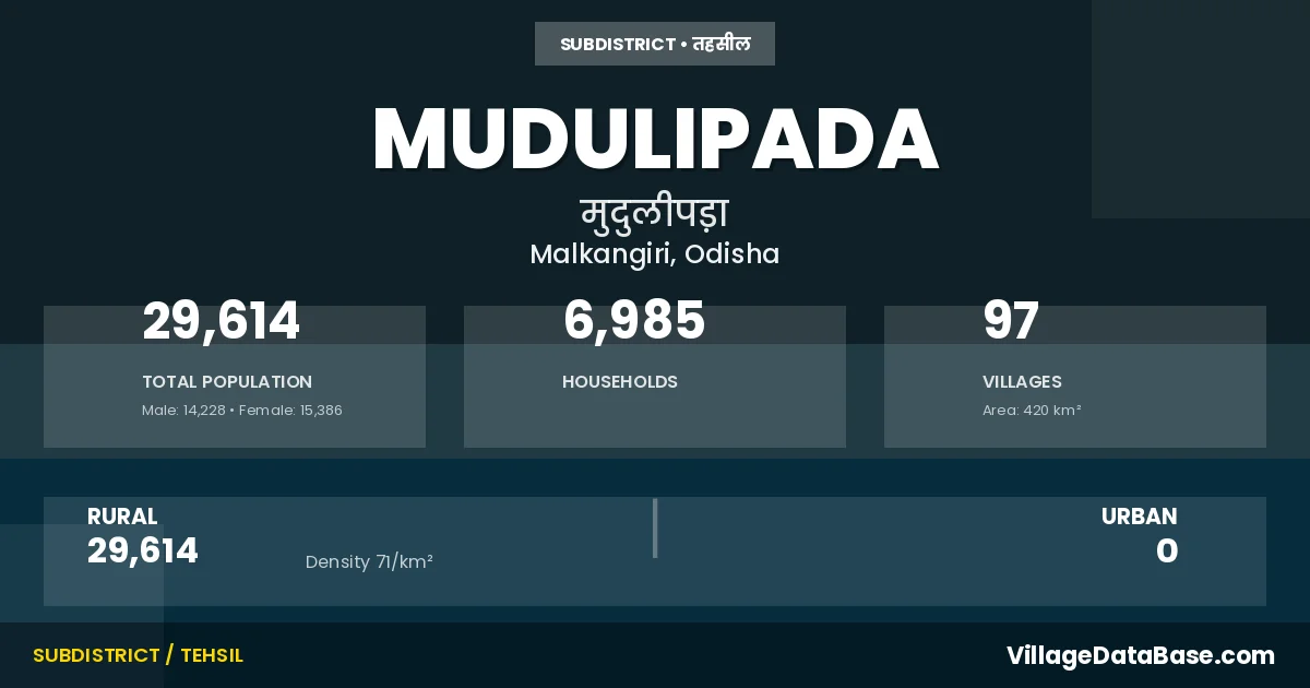
Mudulipada is a town and Tehsil in the Malkangiri district of the Odisha. In India, a Tehsil is a subdivision of a district responsible for the administration and revenue collection of a specific area within the district. Tehsils play a crucial role in the local governance structure, contributing significantly to the development and administration of their communities.
According to the 2011 census The total area of Mudulipada Tehsil is 420 km², with a population of 29614 people. The population density is 71 inhabitants per square kilometre, and there are approximately 6985 houses in the sub district.
Mudulipada Tehsil comprises about 97 villages. Below is a list of these villages along with information about their respective gram panchayats and the nearest town:
| # | Village Name | Gram Panchayat | Nearest Town |
|---|---|---|---|
| 1 | Amalabhata | Podaghat | Jeypur (39 km) |
| 2 | Ambapada | Mathili | Malkangiri (40 km) |
| 3 | Anagel | Badodural | Jeypur (59 km) |
| 4 | Andrahal | Andrahal | Jeypur (56 km) |
| 5 | Anguraguda | Mudulipoda | Malkangiri (140 km) |
| 6 | Aunliput | Kadamguda | Jeypur (35 km) |
| 7 | Badabel | Andrahal | Jeypur (60 km) |
| 8 | Badadural | Badodural | Jeypur (62 km) |
| 9 | Badaliguda | Udulibeda | Jeypur (38 km) |
| 10 | Badapada | Mudulipoda | Jeypur (39 km) |
| 11 | Baliguda | Badodural | Jeypur (40 km) |
| 12 | Balikunda | Badodural | Jeypur (38 km) |
| 13 | Bandhaguda | Badodural | Jeypur (57 km) |
| 14 | Bandiguda | Mudulipoda | Jeypur (58 km) |
| 15 | Baraguda | Mudulipoda | Jeypur (59 km) |
| 16 | Barangabadi | Badodural | Jeypur (40 km) |
| 17 | Basudebapur | Badodural | Jeypur (37 km) |
| 18 | Baunsapada | Mudulipoda | Jeypur (32 km) |
| 19 | Bayaguda | Khairaput | Jeypur (42 km) |
| 20 | Bhaliapadar | Badodural | Jeypur (59 km) |
| 21 | Bondapada | Mudulipoda | Malkangiri (63 km) |
| 22 | Chalanpada | Mudulipoda | Jeypur (62 km) |
| 23 | Champajharan | Udulibeda | Jeypur (64 km) |
| 24 | Chapalapada | Badodural | Jeypur (39 km) |
| 25 | Chimatapali | Govindapalli | Jeypur (60 km) |
| 26 | Dabuguda | Madkapadar | Jeypur (49 km) |
| 27 | Dalapatiguda | Badodural | Jeypur (48 km) |
| 28 | Dangarapalli | Govindapalli | Jeypur (39 km) |
| 29 | Dantipada | Andrahal | Jeypur (63 km) |
| 30 | Dasarathapur | Andrahal | Jeypur (59 km) |
| 31 | Dhemasapadar | Mudulipoda | Jeypur (35 km) |
| 32 | Doraguda | Andrahal | Jeypur (37 km) |
| 33 | Dorapadar | Mudulipoda | Jeypur (37 km) |
| 34 | Dumuripada | Andrahal | Jeypur (48 km) |
| 35 | Gadabapada | Badodural | Jeypur (48 km) |
| 36 | Gangarajguma | Mathili | Malkangiri (39 km) |
| 37 | Gaudaput | Rasbeda | Jeypur (40 km) |
| 38 | Goiguda | Mudulipoda | Jeypur (35 km) |
| 39 | Goilikunda | Mudulipoda | Jeypur (48 km) |
| 40 | Gokharipada | Mudulipoda | Jeypur (60 km) |
| 41 | Gumajharan | Madkapadar | Jeypur (55 km) |
| 42 | Hatamaguda | Andrahal | Jeypur (48 km) |
| 43 | Jhariaguda | Khairaput | Jeypur (37 km) |
| 44 | Kadaguda | Kadamguda | Jeypur (32 km) |
| 45 | Kadamaguda | Kadamguda | Jeypur (35 km) |
| 46 | Kandhaguda | Kadamguda | Jeypur (37 km) |
| 47 | Kandhatalguda | Khairaput | Jeypur (42 km) |
| 48 | Kantabaunsa | Badodural | Jeypur (52 km) |
| 49 | Karadabadi | Khairaput | Jeypur (37 km) |
| 50 | Kasalakondaguma | Madkapadar | Jeypur (55 km) |
| 51 | Katamaguda | Andrahal | Jeypur (62 km) |
| 52 | Kenduguda | Khairaput | Balimela (39 km) |
| 53 | Khairaput | Khairaput | Malkangiri (50 km) |
| 54 | Khemaguru | Govindapalli | Jeypur (42 km) |
| 55 | Khilaguda | Andrahal | Jeypur (72 km) |
| 56 | Kichapada | Mudulipoda | Jeypur (62 km) |
| 57 | Krisanipada | Mudulipoda | Malkangiri (63 km) |
| 58 | Kumbharput | Khairaput | Jeypur (37 km) |
| 59 | Kuriguda | Kadamguda | Jeypur (32 km) |
| 60 | Kusumaput | Govindapalli | Jeypur (65 km) |
| 61 | Kutunipadar | Mudulipoda | Jeypur (39 km) |
| 62 | Lacher | Kadamguda | Jeypur (32 km) |
| 63 | Lamataput | Khairaput | Jeypur (30 km) |
| 64 | Lunakhari | Madkapadar | Jeypur (59 km) |
| 65 | Madakapadar | Madkapadar | Jeypur (60 km) |
| 66 | Mainsikhal | Govindapalli | Jeypur (63 km) |
| 67 | Majhiguda | Badodural | Jeypur (42 km) |
| 68 | Maliguda | Badodural | Jeypur (58 km) |
| 69 | Mudulipada | Mudulipoda | Jeypur (59 km) |
| 70 | Mundiguda | Rasbeda | Jeypur (45 km) |
| 71 | Pakhanaguda | Kadamguda | Jeypur (35 km) |
| 72 | Pandraguda | Kadamguda | Jeypur (30 km) |
| 73 | Paruguda | Madkapadar | Jeypur (63 km) |
| 74 | Patraput | Andrahal | Jeypur (62 km) |
| 75 | Pedaguda | Udulibeda | Jeypur (35 km) |
| 76 | Pindajangar | Mudulipoda | Jeypur (59 km) |
| 77 | Podaghat | Podaghat | Malkangiri (48 km) |
| 78 | Podipada | Badodural | Jeypur (40 km) |
| 79 | Prasantapur | Badodural | Balimela (39 km) |
| 80 | Pujariguda | Udulibeda | Jeypur (39 km) |
| 81 | Pujhariguda | Rasbeda | Jeypur (37 km) |
| 82 | Pusuruguda | Kadamguda | Jeypur (35 km) |
| 83 | Raulguda | Mudulipoda | Jeypur (32 km) |
| 84 | Rauliguda | Andrahal | Jeypur (60 km) |
| 85 | Sanadural | Badodural | Jeypur (42 km) |
| 86 | Sanuguda | Badodural | Jeypur (40 km) |
| 87 | Semiliguda | Rasbeda | Jeypur (37 km) |
| 88 | Silaiguda | Mudulipoda | Jeypur (63 km) |
| 89 | Sindhiguda | Kiango | Jeypur (55 km) |
| 90 | Sisaput | Badodural | Jeypur (42 km) |
| 91 | Sitapur | Mudulipoda | Jeypur (48 km) |
| 92 | Sukriput | Madkapadar | Jeypur (60 km) |
| 93 | Surendrapur | Mudulipoda | Malkangiri (63 km) |
| 94 | Tankamunda | Khairaput | Jeypur (40 km) |
| 95 | Tulaguram | Mudulipoda | Jeypur (40 km) |
| 96 | Tusaipada | Mudulipoda | Jeypur (62 km) |
| 97 | Uparaput | Mudulipoda | Jeypur (40 km) |
The population is distributed between urban and rural areas as follows:
| Particulars | Rural | Urban | Total |
|---|---|---|---|
| Total Population | 29614 | 0 | 29614 |
| Male Population | 14228 | 0 | 14228 |
| Female Population | 15386 | 0 | 15386 | Population Density | 71 / km² | 71 / km² |
The distribution of households in the Mudulipada is:
| Rural Households | Urban Households | Total Households |
|---|---|---|
| 6985 | 0 | 6985 |
Q: What is Mudulipada?
A: Mudulipada is a town and in the Malkangiri district of the Odisha.
Q: What is the total area of Mudulipada Tehsil?
A: The total area of Mudulipada Tehsil is 420 km².
Q: What is the population of Mudulipada Tehsil according to the 2011 census?
A: According to the 2011 census, the population of Mudulipada Tehsil is 29614.
Q: What is the population density of Mudulipada Tehsil?
A: The population density of Mudulipada Tehsil is 71 inhabitants per square kilometre.
Q: How many houses are there in Mudulipada Tehsil?
A: There are approximately 6985 houses in Mudulipada Tehsil.
Q: How many villages are there in Mudulipada Tehsil?
A: There are about 97 villages in Mudulipada Tehsil.
Q: Which is the largest village by population in Mudulipada Tehsil?
A: The largest village by population in Mudulipada Tehsil is Podaghat, with 1552 people.
Q: Which is the smallest village by population in Mudulipada Tehsil?
A: The smallest village by population in Mudulipada Tehsil is Basudebapur, with 0 people.
Q: Which is the largest village by area in Mudulipada Tehsil?
A: The largest village by area in Mudulipada Tehsil is Rauliguda, with 3882 km².
Q: Which is the smallest village by area in Mudulipada Tehsil?
A: The smallest village by area in Mudulipada Tehsil is Anguraguda, with 16 km².
Q: What is the population distribution between urban and rural areas in Mudulipada Tehsil?
A: The population distribution in Mudulipada Tehsil is entirely rural, with a total rural population of 29614.
Q: What is the male population of Mudulipada Tehsil?
A: The male population of Mudulipada Tehsil is 14228.
Q: What is the female population of Mudulipada Tehsil?
A: The female population of Mudulipada Tehsil is 15386.
Q: How is the household distribution in Mudulipada Tehsil?
A: The household distribution in Mudulipada Tehsil is entirely rural, with a total of 6985 households.
Q: How many villages in Mudulipada Tehsil have a population of less than 100?
A: There are 22 villages in Mudulipada Tehsil with a population of less than 100.
Q: How many villages in Mudulipada Tehsil have a population between 100 and 499?
A: There are 59 villages in Mudulipada Tehsil with a population between 100 and 499.
Q: How many villages in Mudulipada Tehsil have a population between 500 and 999?
A: There are 13 villages in Mudulipada Tehsil with a population between 500 and 999.
Q: How many villages in Mudulipada Tehsil have a population between 1000 and 1999?
A: There are 3 villages in Mudulipada Tehsil with a population between 1000 and 1999.
| Total Population | Villages in Sub District Of Mudulipada |
|---|---|
| Less than 100 | 22 |
| 100-499 | 59 |
| 500-999 | 13 |
| 1000-1999 | 3 |