District → Malkangiri
State → Odisha
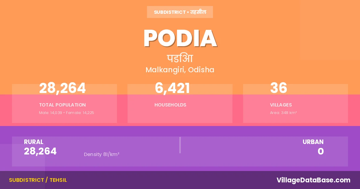
Podia is a town and Tehsil in the Malkangiri district of the Odisha. In India, a Tehsil is a subdivision of a district responsible for the administration and revenue collection of a specific area within the district. Tehsils play a crucial role in the local governance structure, contributing significantly to the development and administration of their communities.
According to the 2011 census The total area of Podia Tehsil is 348 km², with a population of 28264 people. The population density is 81 inhabitants per square kilometre, and there are approximately 6421 houses in the sub district.
Podia Tehsil comprises about 36 villages. Below is a list of these villages along with information about their respective gram panchayats and the nearest town:
| # | Village Name | Gram Panchayat | Nearest Town |
|---|---|---|---|
| 1 | Bapanpali | Bhejangiwada | Malkangiri (75 km) |
| 2 | Batanawada | Materu | Balimela (17 km) |
| 3 | Cheruguda | Niliguda | Balimela (70 km) |
| 4 | Daranpalli | Niliguda | Balimela (27 km) |
| 5 | Deoguda | Chitrangapalli | Balimela (13 km) |
| 6 | Durumaguda | Niliguda | Balimela (21 km) |
| 7 | Erbanpalli | Gumuka | Balimela (18 km) |
| 8 | Gandhiguda | Materu | Balimela (15 km) |
| 9 | Gotanpali | Bapanpalli | Malkangiri (70 km) |
| 10 | Iralgonda | Gompakunda | Balimela (29 km) |
| 11 | Itaguda | Bapanpalli | Balimela (22 km) |
| 12 | Kaladapalli | Kaldapalli | Malkangiri (90 km) |
| 13 | Kapanpalli | Similibancha | Malkangiri (70 km) |
| 14 | Khillaguda | Matapaka | Balimela (14 km) |
| 15 | Kolaganda | Kaldapalli | Balimela (70 km) |
| 16 | Kotaguda | Podia | Malkangiri (70 km) |
| 17 | Kunchanpalli | Podia | Malkangiri (70 km) |
| 18 | Kunjharguda | Telerai | Balimela (10 km) |
| 19 | M P V 56 | Girkanpalli | Balimela (17 km) |
| 20 | Materu | Materu | Balimela (10 km) |
| 21 | Nandiwada | Niliguda | Balimela (24 km) |
| 22 | Niliguda | Niliguda | Balimela (19 km) |
| 23 | Nunurguda | Nalagunthi | Balimela (20 km) |
| 24 | Pangata | Podia | Balimela (5 km) |
| 25 | Parsanpalli | Materu | Balimela (13 km) |
| 26 | Pegadapalli | Mottu | Balimela (15 km) |
| 27 | Peruwai | Chitrangapalli | Malkangiri (56 km) |
| 28 | Podia | Podia | Malkangiri (70 km) |
| 29 | Polur | Bapanpalli | Malkangiri (82 km) |
| 30 | Ramaguda | Gumuka | Balimela (22 km) |
| 31 | Rodanpalli | Bapanpalli | Balimela (8 km) |
| 32 | Silakota | Bapanpalli | Balimela (15 km) |
| 33 | Supulur | Kaldapalli | Malkangiri (70 km) |
| 34 | Udaygiri | Kalimela | Malkangiri (80 km) |
| 35 | Uskalbag | Niliguda | Balimela (21 km) |
| 36 | Venchanpalli | Venkatapallam | Balimela (9 km) |
The population is distributed between urban and rural areas as follows:
| Particulars | Rural | Urban | Total |
|---|---|---|---|
| Total Population | 28264 | 0 | 28264 |
| Male Population | 14039 | 0 | 14039 |
| Female Population | 14225 | 0 | 14225 | Population Density | 81 / km² | 81 / km² |
The distribution of households in the Podia is:
| Rural Households | Urban Households | Total Households |
|---|---|---|
| 6421 | 0 | 6421 |
Q: What is Podia?
A: Podia is a town and in the Malkangiri district of the Odisha.
Q: What is the total area of Podia Tehsil?
A: The total area of Podia Tehsil is 348 km².
Q: What is the population of Podia Tehsil according to the 2011 census?
A: According to the 2011 census, the population of Podia Tehsil is 28264.
Q: What is the population density of Podia Tehsil?
A: The population density of Podia Tehsil is 81 inhabitants per square kilometre.
Q: How many houses are there in Podia Tehsil?
A: There are approximately 6421 houses in Podia Tehsil.
Q: How many villages are there in Podia Tehsil?
A: There are about 36 villages in Podia Tehsil.
Q: Which is the largest village by population in Podia Tehsil?
A: The largest village by population in Podia Tehsil is Podia, with 5570 people.
Q: Which is the smallest village by population in Podia Tehsil?
A: The smallest village by population in Podia Tehsil is Gandhiguda, with 0 people.
Q: Which is the largest village by area in Podia Tehsil?
A: The largest village by area in Podia Tehsil is Podia, with 2802 km².
Q: Which is the smallest village by area in Podia Tehsil?
A: The smallest village by area in Podia Tehsil is Deoguda, with 0 km².
Q: What is the population distribution between urban and rural areas in Podia Tehsil?
A: The population distribution in Podia Tehsil is entirely rural, with a total rural population of 28264.
Q: What is the male population of Podia Tehsil?
A: The male population of Podia Tehsil is 14039.
Q: What is the female population of Podia Tehsil?
A: The female population of Podia Tehsil is 14225.
Q: How is the household distribution in Podia Tehsil?
A: The household distribution in Podia Tehsil is entirely rural, with a total of 6421 households.
Q: How many villages in Podia Tehsil have a population of less than 100?
A: There are 3 villages in Podia Tehsil with a population of less than 100.
Q: How many villages in Podia Tehsil have a population between 100 and 499?
A: There are 13 villages in Podia Tehsil with a population between 100 and 499.
Q: How many villages in Podia Tehsil have a population between 500 and 999?
A: There are 10 villages in Podia Tehsil with a population between 500 and 999.
Q: How many villages in Podia Tehsil have a population between 1000 and 1999?
A: There are 9 villages in Podia Tehsil with a population between 1000 and 1999.
Q: How many villages in Podia Tehsil have a population of 5000 and above?
A: There is 1 village in Podia Tehsil with a population of 5000 and above.
| Total Population | Villages in Sub District Of Podia |
|---|---|
| Less than 100 | 3 |
| 100-499 | 13 |
| 500-999 | 10 |
| 1000-1999 | 9 |
| 5000 And Above | 1 |