Chandua: A Town and Tehsil in Mayurbhanj district
District → Mayurbhanj
State → Odisha
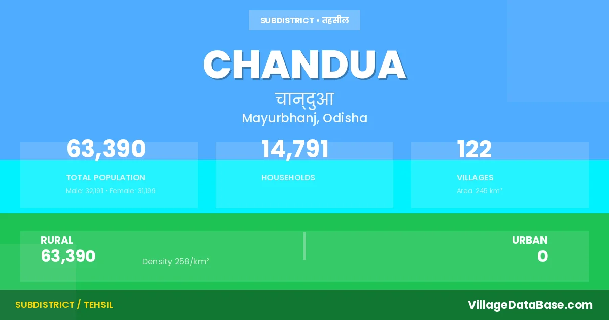
Chandua is a town and Tehsil in the Mayurbhanj district of the Odisha. In India, a Tehsil is a subdivision of a district responsible for the administration and revenue collection of a specific area within the district. Tehsils play a crucial role in the local governance structure, contributing significantly to the development and administration of their communities.
According to the 2011 census The total area of Chandua Tehsil is 245 km², with a population of 63390 people. The population density is 258 inhabitants per square kilometre, and there are approximately 14791 houses in the sub district.
Chandua Tehsil comprises about 122 villages. Below is a list of these villages along with information about their respective gram panchayats and the nearest town:
| # | Village Name | Gram Panchayat | Nearest Town |
|---|---|---|---|
| 1 | Adiamara | Chandua | Baripada (18 km) |
| 2 | Andarjoda | Chandua | Baripada (20 km) |
| 3 | Anlakuda | Anlakuda | Baripada (20 km) |
| 4 | Badasarasposi | Nodhana | Baripada (25 km) |
| 5 | Badasol | Deuli | Baripada (20 km) |
| 6 | Badbadtalia | Keutunimari | Baripada (26 km) |
| 7 | Badpalasia | Saragachhida | Baripada (22 km) |
| 8 | Badtilau | Saragachhida | Baripada (22 km) |
| 9 | Baghbani | Chandua | Baripada (17 km) |
| 10 | Baghuasul | Anlakuda | Baripada (35 km) |
| 11 | Baidpur | Nodhana | Baripada (19 km) |
| 12 | Baliatilau | Keutunimari | Baripada (22 km) |
| 13 | Balichaturi | Chandua | Baripada (30 km) |
| 14 | Banadav | Chandua | Baripada (30 km) |
| 15 | Bangriposi | Anlakuda | Baripada (22 km) |
| 16 | Bankaanla | Saragachhida | Baripada (34 km) |
| 17 | Baragenja | Chandua | Baripada (31 km) |
| 18 | Baunsabani | Chandua | Baripada (25 km) |
| 19 | Bedhi | Deuli | Baripada (21 km) |
| 20 | Belerisol | Chandua | Baripada (32 km) |
| 21 | Betnota | Kuabuda | Baripada (16 km) |
| 22 | Bhagabandha | Kuabuda | Baripada (12 km) |
| 23 | Bholabeda | Saragachhida | Baripada (30 km) |
| 24 | Bhugudakata | Saragachhida | Baripada (30 km) |
| 25 | Bhurungasol | Nodhana | Baripada (25 km) |
| 26 | Bhuyangoda | Marangtandi | Baripada (10 km) |
| 27 | Bijaykrushnachandrapur | Deuli | Baripada (17 km) |
| 28 | Budamara | Deuli | Baripada (20 km) |
| 29 | Chahalapada | Saragachhida | Baripada (20 km) |
| 30 | Chaksuliapada | Anlakuda | Baripada (23 km) |
| 31 | Chalunia | Saragachhida | Baripada (27 km) |
| 32 | Chandua | Chandua | Baripada (25 km) |
| 33 | Charmania | Saragachhida | Baripada (28 km) |
| 34 | Chhelikani | Nodhana | Baripada (22 km) |
| 35 | Dardara | Keutunimari | Baripada (19 km) |
| 36 | Dardiasole | Keutunimari | Baripada (18 km) |
| 37 | Deuli | Deuli | Baripada (17 km) |
| 38 | Dhadipada | Kuabuda | Baripada (17 km) |
| 39 | Dhanimari | Chandua | Baripada (18 km) |
| 40 | Dhemnasol | Chandua | Baripada (21 km) |
| 41 | Dhobanisul | Anlakuda | Baripada (18 km) |
| 42 | Dublabeda | Kuabuda | Baripada (13 km) |
| 43 | Dudhakundi | Chandua | Baripada (31 km) |
| 44 | Dudhiasul | Nodhana | Baripada (22 km) |
| 45 | Fuljhara | Keutunimari | Baripada (22 km) |
| 46 | Gadubhanga | Kuabuda | Baripada (15 km) |
| 47 | Gayalkata | Keutunimari | Baripada (24 km) |
| 48 | Ghuntabani | Saragachhida | Baripada (30 km) |
| 49 | Godargodi | Saragachhida | Baripada (28 km) |
| 50 | Gundurilocha | Deuli | Baripada (15 km) |
| 51 | Hadhadibangan | Nodhana | Baripada (24 km) |
| 52 | Hatibari | Saragachhida | Baripada (35 km) |
| 53 | Hatimada | Keutunimari | Baripada (20 km) |
| 54 | Jamjarki | Nodhana | Baripada (28 km) |
| 55 | Jamsul | Nodhana | Baripada (25 km) |
| 56 | Jhaliamara | Anlakuda | Baripada (24 km) |
| 57 | Jhanjdapal | Marangtandi | Baripada (10 km) |
| 58 | Jhinei | Marangtandi | Baripada (15 km) |
| 59 | Jiani | Marangtandi | Baripada (8 km) |
| 60 | Junbani | Nuagaon | Baripada (16 km) |
| 61 | Kadapatia | Deuli | Baripada (19 km) |
| 62 | Kakharusole | Chandua | Baripada (28 km) |
| 63 | Kaladam | Saragachhida | Baripada (22 km) |
| 64 | Kalajhinei | Kuabuda | Baripada (11 km) |
| 65 | Kalikasole | Keutunimari | Baripada (20 km) |
| 66 | Kamarpal | Gendapokhari | Baripada (19 km) |
| 67 | Karkachia | Nodhana | Baripada (17 km) |
| 68 | Kathgandia | Chandua | Baripada (22 km) |
| 69 | Kesharpur | Nodhana | Baripada (27 km) |
| 70 | Keutunimari | Keutunimari | Baripada (16 km) |
| 71 | Khadiasul | Nuagaon | Baripada (16 km) |
| 72 | Khaikhia | Chandua | Baripada (19 km) |
| 73 | Khandarpada | Chandua | Baripada (23 km) |
| 74 | Kothabilla | Nodhana | Baripada (25 km) |
| 75 | Kuabuda | Kuabuda | Baripada (15 km) |
| 76 | Kusumasole | Anlakuda | Baripada (25 km) |
| 77 | Madhapur | Nodhana | Baripada (28 km) |
| 78 | Mankadkenda | Marangtandi | Baripada (12 km) |
| 79 | Marangtandi | Marangtandi | Baripada (15 km) |
| 80 | Masinakathi | Nuagaon | Baripada (15 km) |
| 81 | Nabedhi | Kuliana | Baripada (30 km) |
| 82 | Nadhna | Nodhana | Baripada (28 km) |
| 83 | Nadigan | Anlakuda | Baripada (28 km) |
| 84 | Nagrasol | Saragachhida | Baripada (27 km) |
| 85 | Nagsol | Anlakuda | Baripada (18 km) |
| 86 | Nayadudhiasole | Nodhana | Baripada (28 km) |
| 87 | Nedhua | Chandua | Baripada (20 km) |
| 88 | Nodhabani | Keutunimari | Baripada (16 km) |
| 89 | Nuagan | Nuagaon | Baripada (14 km) |
| 90 | Nuhamalia | Chandua | Baripada (31 km) |
| 91 | Pandasole | Keutunimari | Baripada (21 km) |
| 92 | Pathara | Chandua | Baripada (16 km) |
| 93 | Pathuri | Deuli | Baripada (15 km) |
| 94 | Podadiha | Anlakuda | Baripada (21 km) |
| 95 | Podugirisole | Nuagaon | Baripada (15 km) |
| 96 | Pushigan | Deuli | Baripada (18 km) |
| 97 | Raghunathpur | Marangtandi | Baripada (8 km) |
| 98 | Ramkadali | Keutunimari | Baripada (20 km) |
| 99 | Rangamatia | Anlakuda | Baripada (20 km) |
| 100 | Rangibeda | Keutunimari | Baripada (17 km) |
| 101 | Rangisole | Keutunimari | Baripada (19 km) |
| 102 | Rathasol | Keutunimari | Baripada (22 km) |
| 103 | Saluabeda | Chandua | Baripada (30 km) |
| 104 | Sampura | Deuli | Baripada (32 km) |
| 105 | Sanjogibandh | Deuli | Baripada (16 km) |
| 106 | Sannuagan | Keutunimari | Baripada (15 km) |
| 107 | Sansarasposi | Nodhana | Baripada (22 km) |
| 108 | Saragchhida | Saragachhida | Baripada (28 km) |
| 109 | Sarasposi | Deuli | Baripada (13 km) |
| 110 | Satpautia | Nodhana | Baripada (25 km) |
| 111 | Sindurgoura | Deuli | Baripada (17 km) |
| 112 | Sirispada | Deuli | Baripada (2 km) |
| 113 | Srichandanpur | Chandua | Baripada (31 km) |
| 114 | Sunaposi | Keutunimari | Baripada (20 km) |
| 115 | Sunaria | Chandua | Baripada (28 km) |
| 116 | Tadaki | Keutunimari | Baripada (17 km) |
| 117 | Taldiha | Anlakuda | Baripada (30 km) |
| 118 | Tamudiasul | Chandua | Baripada (22 km) |
| 119 | Tangasole | Saragachhida | Baripada (20 km) |
| 120 | Tolakchuin | Nuagaon | Baripada (16 km) |
| 121 | Tubulbhadu | Saragachhida | Baripada (27 km) |
| 122 | Tulasibani | Chandua | Baripada (26 km) |
The population is distributed between urban and rural areas as follows:
| Particulars | Rural | Urban | Total |
|---|---|---|---|
| Total Population | 63390 | 0 | 63390 |
| Male Population | 32191 | 0 | 32191 |
| Female Population | 31199 | 0 | 31199 | Population Density | 258 / km² | 258 / km² |
The distribution of households in the Chandua is:
| Rural Households | Urban Households | Total Households |
|---|---|---|
| 14791 | 0 | 14791 |
Q: What is Chandua?
A: Chandua is a town and in the Mayurbhanj district of the Odisha.
Q: What is the total area of Chandua Tehsil?
A: The total area of Chandua Tehsil is 245 km².
Q: What is the population of Chandua Tehsil according to the 2011 census?
A: According to the 2011 census, the population of Chandua Tehsil is 63390.
Q: What is the population density of Chandua Tehsil?
A: The population density of Chandua Tehsil is 258 inhabitants per square kilometre.
Q: How many houses are there in Chandua Tehsil?
A: There are approximately 14791 houses in Chandua Tehsil.
Q: How many villages are there in Chandua Tehsil?
A: There are about 122 villages in Chandua Tehsil.
Q: Which is the largest village by population in Chandua Tehsil?
A: The largest village by population in Chandua Tehsil is Chandua, with 1507 people.
Q: Which is the smallest village by population in Chandua Tehsil?
A: The smallest village by population in Chandua Tehsil is Baghbani, with 0 people.
Q: Which is the largest village by area in Chandua Tehsil?
A: The largest village by area in Chandua Tehsil is Jhinei, with 679 km².
Q: Which is the smallest village by area in Chandua Tehsil?
A: The smallest village by area in Chandua Tehsil is Baragenja, with 14 km².
Q: What is the population distribution between urban and rural areas in Chandua Tehsil?
A: The population distribution in Chandua Tehsil is entirely rural, with a total rural population of 63390.
Q: What is the male population of Chandua Tehsil?
A: The male population of Chandua Tehsil is 32191.
Q: What is the female population of Chandua Tehsil?
A: The female population of Chandua Tehsil is 31199.
Q: How is the household distribution in Chandua Tehsil?
A: The household distribution in Chandua Tehsil is entirely rural, with a total of 14791 households.
Q: How many villages in Chandua Tehsil have a population of less than 100?
A: There are 14 villages in Chandua Tehsil with a population of less than 100.
Q: How many villages in Chandua Tehsil have a population between 100 and 499?
A: There are 54 villages in Chandua Tehsil with a population between 100 and 499.
Q: How many villages in Chandua Tehsil have a population between 500 and 999?
A: There are 36 villages in Chandua Tehsil with a population between 500 and 999.
Q: How many villages in Chandua Tehsil have a population between 1000 and 1999?
A: There are 18 villages in Chandua Tehsil with a population between 1000 and 1999.
| Total Population | Villages in Sub District Of Chandua |
|---|---|
| Less than 100 | 14 |
| 100-499 | 54 |
| 500-999 | 36 |
| 1000-1999 | 18 |