District → Mayurbhanj
State → Odisha
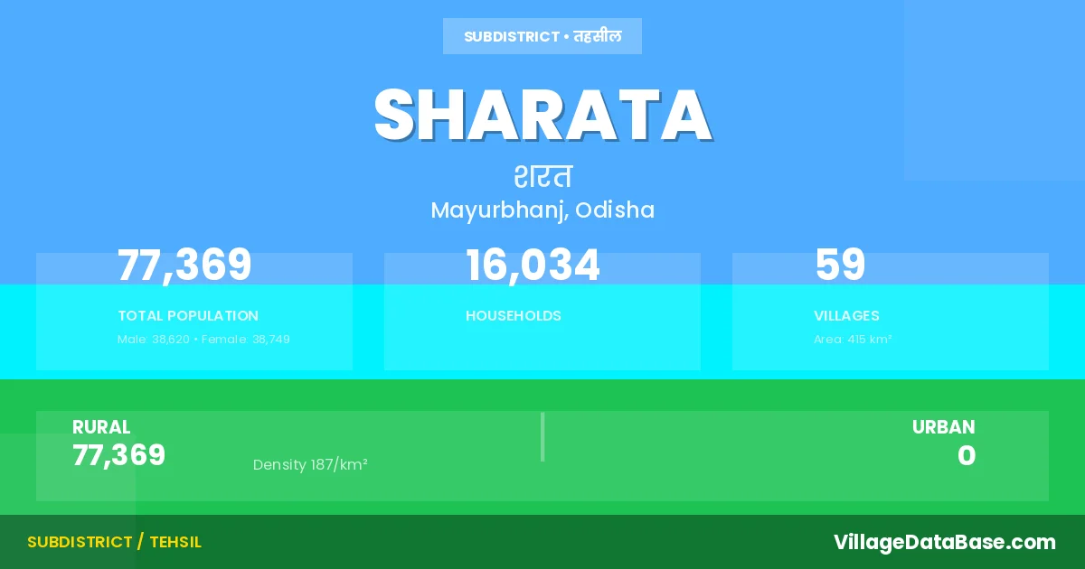
Sharata is a town and Tehsil in the Mayurbhanj district of the Odisha. In India, a Tehsil is a subdivision of a district responsible for the administration and revenue collection of a specific area within the district. Tehsils play a crucial role in the local governance structure, contributing significantly to the development and administration of their communities.
According to the 2011 census The total area of Sharata Tehsil is 415 km², with a population of 77369 people. The population density is 187 inhabitants per square kilometre, and there are approximately 16034 houses in the sub district.
Sharata Tehsil comprises about 59 villages. Below is a list of these villages along with information about their respective gram panchayats and the nearest town:
| # | Village Name | Gram Panchayat | Nearest Town |
|---|---|---|---|
| 1 | Badasimilia | Jadida | Udala (15 km) |
| 2 | Baghadafa | Notto | Udala (43 km) |
| 3 | Baladamara | Majhigadia | Udala (23 km) |
| 4 | Balichua | Kalamgadia | Udala (52 km) |
| 5 | Bhaluhuruda | Sarat | Udala (15 km) |
| 6 | Bhandar | Sardiha | Udala (33 km) |
| 7 | Bidyadharanagar | Salchua | Udala (22 km) |
| 8 | Bisungaon | Dewanbahali | Udala (35 km) |
| 9 | Dangarsahi | Majhigadia | Udala (23 km) |
| 10 | Dewanbahali | Dewanbahali | Udala (25 km) |
| 11 | Dhapada | Padmapokhari | Udala (28 km) |
| 12 | Dillisahar | Ranipokhari | Udala (37 km) |
| 13 | Dolipada | Ramchandrapur | Udala (32 km) |
| 14 | Dugudha | Kalamgadia | Udala (55 km) |
| 15 | Gaipanikhiahill | Labanyadeipur | Udala (22 km) |
| 16 | Gayalmara | Mankadapada | Udala (16 km) |
| 17 | Gendagadia | Salchua | Udala (17 km) |
| 18 | Gokulpur | Kalamgadia | Udala (45 km) |
| 19 | Gourchandrapur | Sarat | Udala (35 km) |
| 20 | Jadida | Jadida | Udala (14 km) |
| 21 | Jamubani | Sarat | Udala (21 km) |
| 22 | Jayaguntia | Badkhaladi | Udala (13 km) |
| 23 | Kadabahali | Sarat | Udala (43 km) |
| 24 | Kalamgadia | Kalamgadia | Udala (50 km) |
| 25 | Kathachua | Kalamgadia | Udala (52 km) |
| 26 | Katuria | Labanyadeipur | Udala (25 km) |
| 27 | Kumudabadi | Notto | Udala (40 km) |
| 28 | Kusunpur | Badkhaladi | Udala (13 km) |
| 29 | Labanyadeipur | Labanyadeipur | Udala (28 km) |
| 30 | Mahisasuri | Badkhaladi | Udala (13 km) |
| 31 | Mahulpankha | Majhigadia | Udala (25 km) |
| 32 | Majhigadia | Majhigadia | Udala (23 km) |
| 33 | Mankadpada Hill | Mankadapada | Udala (25 km) |
| 34 | Nedam | Jadida | Udala (14 km) |
| 35 | Noto | Notto | Udala (36 km) |
| 36 | Padmapokhari | Padmapokhari | Udala (28 km) |
| 37 | Parasabadi | Mankadapada | Udala (25 km) |
| 38 | Phulbadia Hill Block | Sarat | Udala (15 km) |
| 39 | Prafullachandrapur | Kalamgadia | Udala (55 km) |
| 40 | Prasanachandrapur | Notto | Udala (40 km) |
| 41 | Raidiha | Majhigadia | Udala (23 km) |
| 42 | Raikala | Jadida | Udala (14 km) |
| 43 | Raikalachua | Majhigadia | Udala (23 km) |
| 44 | Rajatnagar | Ranipokhari | Udala (35 km) |
| 45 | Ramchandrapur | Ramchandrapur | Udala (50 km) |
| 46 | Ranipokhari | Ranipokhari | Udala (38 km) |
| 47 | Salachua | Salchua | Udala (23 km) |
| 48 | Sanadei | Labanyadeipur | Udala (24 km) |
| 49 | Saradiha | Sardiha | Udala (44 km) |
| 50 | Sarat | Sarat | Udala (35 km) |
| 51 | Siriapal | Dewanbahali | Udala (37 km) |
| 52 | Sologodia | Salchua | Udala (18 km) |
| 53 | Sripadamanjaripur | Kalamgadia | Udala (46 km) |
| 54 | Sukhuapata | Sardiha | Udala (44 km) |
| 55 | Sukhuapata Hill | Kalamgadia | Udala (50 km) |
| 56 | Sundhal | Badkhaladi | Udala (13 km) |
| 57 | Talapokhari | Jadida | Udala (14 km) |
| 58 | Thakurasahi | Sarat | Udala (16 km) |
| 59 | Tolagadia | Ramchandrapur | Udala (32 km) |
The population is distributed between urban and rural areas as follows:
| Particulars | Rural | Urban | Total |
|---|---|---|---|
| Total Population | 77369 | 0 | 77369 |
| Male Population | 38620 | 0 | 38620 |
| Female Population | 38749 | 0 | 38749 | Population Density | 187 / km² | 187 / km² |
The distribution of households in the Sharata is:
| Rural Households | Urban Households | Total Households |
|---|---|---|
| 16034 | 0 | 16034 |
Q: What is Sharata?
A: Sharata is a town and in the Mayurbhanj district of the Odisha.
Q: What is the total area of Sharata Tehsil?
A: The total area of Sharata Tehsil is 415 km².
Q: What is the population of Sharata Tehsil according to the 2011 census?
A: According to the 2011 census, the population of Sharata Tehsil is 77369.
Q: What is the population density of Sharata Tehsil?
A: The population density of Sharata Tehsil is 187 inhabitants per square kilometre.
Q: How many houses are there in Sharata Tehsil?
A: There are approximately 16034 houses in Sharata Tehsil.
Q: How many villages are there in Sharata Tehsil?
A: There are about 59 villages in Sharata Tehsil.
Q: Which is the largest village by population in Sharata Tehsil?
A: The largest village by population in Sharata Tehsil is Sarat, with 3899 people.
Q: Which is the smallest village by population in Sharata Tehsil?
A: The smallest village by population in Sharata Tehsil is Kusunpur, with 185 people.
Q: Which is the largest village by area in Sharata Tehsil?
A: The largest village by area in Sharata Tehsil is Sukhuapata Hill, with 3217 km².
Q: Which is the smallest village by area in Sharata Tehsil?
A: The smallest village by area in Sharata Tehsil is Kusunpur, with 14 km².
Q: What is the population distribution between urban and rural areas in Sharata Tehsil?
A: The population distribution in Sharata Tehsil is entirely rural, with a total rural population of 77369.
Q: What is the male population of Sharata Tehsil?
A: The male population of Sharata Tehsil is 38620.
Q: What is the female population of Sharata Tehsil?
A: The female population of Sharata Tehsil is 38749.
Q: How is the household distribution in Sharata Tehsil?
A: The household distribution in Sharata Tehsil is entirely rural, with a total of 16034 households.
Q: How many villages in Sharata Tehsil have a population between 100 and 499?
A: There are 10 villages in Sharata Tehsil with a population between 100 and 499.
Q: How many villages in Sharata Tehsil have a population between 500 and 999?
A: There are 16 villages in Sharata Tehsil with a population between 500 and 999.
Q: How many villages in Sharata Tehsil have a population between 1000 and 1999?
A: There are 22 villages in Sharata Tehsil with a population between 1000 and 1999.
Q: How many villages in Sharata Tehsil have a population between 2000 and 2999?
A: There is 7 village in Sharata Tehsil with a population between 2000 and 2999.
Q: How many villages in Sharata Tehsil have a population between 3000 and 3999?
A: There is 4 village in Sharata Tehsil with a population between 3000 and 3999.
| Total Population | Villages in Sub District Of Sharata |
|---|---|
| 100-499 | 10 |
| 500-999 | 16 |
| 1000-1999 | 22 |
| 2000-2999 | 7 |
| 3000-3999 | 4 |