Chandahandi: A Town and Tehsil in Nabarangapur district
District → Nabarangapur
State → Odisha
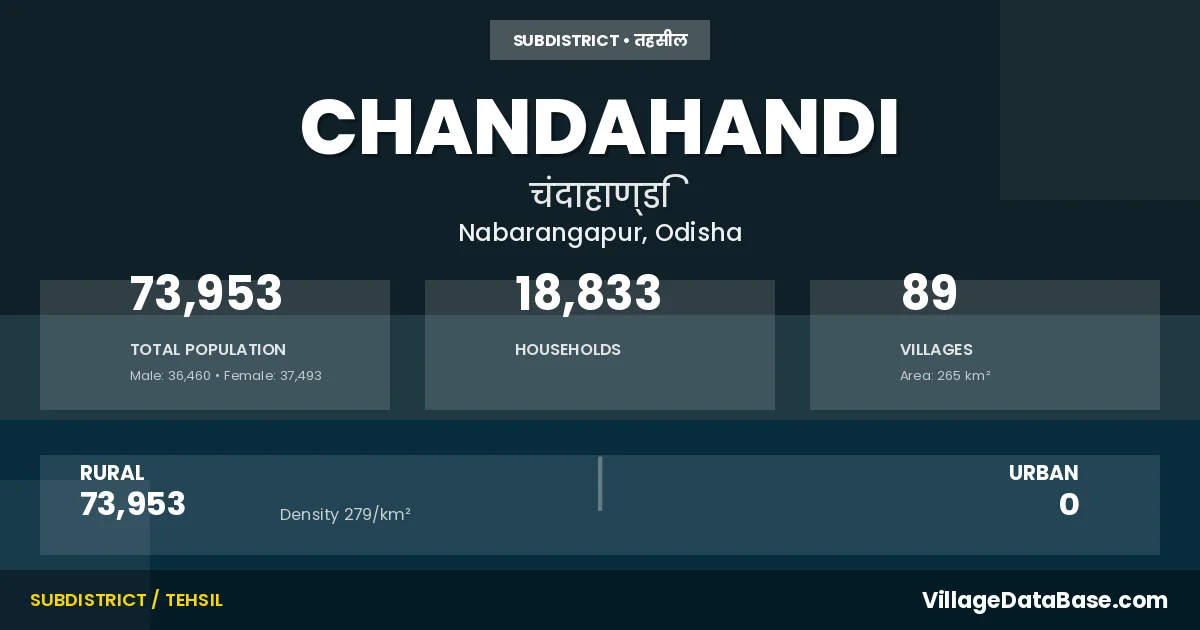
Chandahandi is a town and Tehsil in the Nabarangapur district of the Odisha. In India, a Tehsil is a subdivision of a district responsible for the administration and revenue collection of a specific area within the district. Tehsils play a crucial role in the local governance structure, contributing significantly to the development and administration of their communities.
According to the 2011 census The total area of Chandahandi Tehsil is 265 km², with a population of 73953 people. The population density is 279 inhabitants per square kilometre, and there are approximately 18833 houses in the sub district.
Chandahandi Tehsil comprises about 89 villages. Below is a list of these villages along with information about their respective gram panchayats and the nearest town:
| # | Village Name | Gram Panchayat | Nearest Town |
|---|---|---|---|
| 1 | Ambaguda | Mohara | Umarkote (47 km) |
| 2 | Ankabeda | Anakabeda | Umarkote (52 km) |
| 3 | Antipara | Dalabeda | Umarkote (60 km) |
| 4 | Badamunda | Mohara | Umarkote (46 km) |
| 5 | Baidipara | Patakhalia | Umarkote (58 km) |
| 6 | Banamahuli | Dalabeda | Umarkote (65 km) |
| 7 | Bandhokona | Patakhalia | Umarkote (60 km) |
| 8 | Batajhar | Phataki | Umarkote (39 km) |
| 9 | Beheramunda | Beheramunda | Umarkote (56 km) |
| 10 | Belmajhiguda | Beheramunda | Umarkote (58 km) |
| 11 | Bhaludangari | Jamadarpada | Umarkote (60 km) |
| 12 | Bhatipara | Dalabeda | Umarkote (58 km) |
| 13 | Bhendiagam | Malgam | Umarkote (65 km) |
| 14 | Bhojapur | Malgam | Umarkote (68 km) |
| 15 | Bobria | Beheramunda | Umarkote (54 km) |
| 16 | Boriguda | Mohara | Umarkote (46 km) |
| 17 | Chakamal | Anakabeda | Umarkote (46 km) |
| 18 | Chandahandi | Chandahandi | Umarkote (50 km) |
| 19 | Chandgiri | Anakabeda | Umarkote (48 km) |
| 20 | Chiligam | Patakhalia | Umarkote (60 km) |
| 21 | Dahimal I | Kuhudi | Umarkote (70 km) |
| 22 | Dalbeda | Dalabeda | Umarkote (60 km) |
| 23 | Dandamunda | Dhodipani | Umarkote (55 km) |
| 24 | Dangriguda | Dhodipani | Umarkote (60 km) |
| 25 | Dhanarakote | Phataki | Umarkote (42 km) |
| 26 | Dhepaguda | Malgam | Umarkote (63 km) |
| 27 | Dhodipani | Dhodipani | Umarkote (57 km) |
| 28 | Dhoruapara | Patakhalia | Umarkote (58 km) |
| 29 | Dhupkote | Anakabeda | Umarkote (45 km) |
| 30 | Dhuruapara | Patakhalia | Umarkote (53 km) |
| 31 | Forest Village | Malgam | Umarkote (63 km) |
| 32 | Gambhariguda | Gambhariguda | Umarkote (60 km) |
| 33 | Ghantaguda | Koilimunda | Umarkote (50 km) |
| 34 | Ghungutipara | Dalabeda | Umarkote (46 km) |
| 35 | Gorakhabanda | Jamadarpada | Umarkote (56 km) |
| 36 | Guma | Beheramunda | Umarkote (55 km) |
| 37 | Haldi | Chandahandi | Umarkote (58 km) |
| 38 | Haldikhaliapara | Jamadarpada | Umarkote (60 km) |
| 39 | Haridapara | Dhodipani | Umarkote (65 km) |
| 40 | Jamadarpara | Jamadarpada | Umarkote (47 km) |
| 41 | Jampara | Saradhapur | Umarkote (59 km) |
| 42 | Jhaliapara | Beheramunda | Umarkote (58 km) |
| 43 | Jharabahal | Saradhapur | Umarkote (55 km) |
| 44 | Jhorabandho | Anakabeda | Umarkote (50 km) |
| 45 | Jhulenbara | Koilimunda | Umarkote (49 km) |
| 46 | Junapani | Chandahandi | Umarkote (54 km) |
| 47 | Kandioda | Jamadarpada | Umarkote (43 km) |
| 48 | Karlapara | Patakhalia | Umarkote (60 km) |
| 49 | Kenduguda | Koilimunda | Umarkote (50 km) |
| 50 | Khadakhadi | Koilimunda | Umarkote (44 km) |
| 51 | Khapradihi | Gambhariguda | Umarkote (74 km) |
| 52 | Khoirabadi | Gambhariguda | Umarkote (60 km) |
| 53 | Khuntiguda | Dalabeda | Umarkote (57 km) |
| 54 | Kocharapara | Dalabeda | Umarkote (65 km) |
| 55 | Kodobhata | Koilimunda | Umarkote (49 km) |
| 56 | Koilimunda | Koilimunda | Umarkote (48 km) |
| 57 | Koradangari | Jamadarpada | Umarkote (45 km) |
| 58 | Kuambo | Kuhudi | Umarkote (75 km) |
| 59 | Kuhudi | Kuhudi | Umarkote (75 km) |
| 60 | Lodhuapara | Phataki | Umarkote (38 km) |
| 61 | Longpara | Jamadarpada | Umarkote (60 km) |
| 62 | Luhabahili | Dhodipani | Umarkote (70 km) |
| 63 | Mahura | Mohara | Umarkote (114 km) |
| 64 | Malgam | Malgam | Umarkote (62 km) |
| 65 | Malibari | Saradhapur | Umarkote (60 km) |
| 66 | Malpara | Koilimunda | Umarkote (45 km) |
| 67 | Malpoda | Koilimunda | Umarkote (55 km) |
| 68 | Motigan | Gambhariguda | Umarkote (57 km) |
| 69 | Nahalmunda | Mohara | Umarkote (50 km) |
| 70 | Nuapara | Anakabeda | Umarkote (50 km) |
| 71 | Palsapara | Dhodipani | Umarkote (60 km) |
| 72 | Patokhalia | Patakhalia | Umarkote (57 km) |
| 73 | Phatamunda | Dhodipani | Umarkote (60 km) |
| 74 | Phatki | Phataki | Umarkote (40 km) |
| 75 | Phundelpara | Gambhariguda | Umarkote (58 km) |
| 76 | Pujariguda | Mohara | Umarkote (52 km) |
| 77 | Rajkote | Patakhalia | Umarkote (60 km) |
| 78 | Salebhota | Beheramunda | Umarkote (50 km) |
| 79 | Salebidi I | Beheramunda | Umarkote (52 km) |
| 80 | Salebidi Ii | Chandahandi | Umarkote (52 km) |
| 81 | Sandhimunda | Anakabeda | Umarkote (49 km) |
| 82 | Sardhapur | Saradhapur | Umarkote (59 km) |
| 83 | Sargibahal | Gambhariguda | Umarkote (61 km) |
| 84 | Semalaguda | Chandahandi | Umarkote (54 km) |
| 85 | Siunapali | Chandahandi | Umarkote (55 km) |
| 86 | Souraguda | Saradhapur | Umarkote (65 km) |
| 87 | Telimala | Koilimunda | Umarkote (47 km) |
| 88 | Teltandi | Saradhapur | Umarkote (59 km) |
| 89 | Tentulipara | Jamadarpada | Umarkote (47 km) |
The population is distributed between urban and rural areas as follows:
| Particulars | Rural | Urban | Total |
|---|---|---|---|
| Total Population | 73953 | 0 | 73953 |
| Male Population | 36460 | 0 | 36460 |
| Female Population | 37493 | 0 | 37493 | Population Density | 279 / km² | 279 / km² |
The distribution of households in the Chandahandi is:
| Rural Households | Urban Households | Total Households |
|---|---|---|
| 18833 | 0 | 18833 |
Q: What is Chandahandi?
A: Chandahandi is a town and in the Nabarangapur district of the Odisha.
Q: What is the total area of Chandahandi Tehsil?
A: The total area of Chandahandi Tehsil is 265 km².
Q: What is the population of Chandahandi Tehsil according to the 2011 census?
A: According to the 2011 census, the population of Chandahandi Tehsil is 73953.
Q: What is the population density of Chandahandi Tehsil?
A: The population density of Chandahandi Tehsil is 279 inhabitants per square kilometre.
Q: How many houses are there in Chandahandi Tehsil?
A: There are approximately 18833 houses in Chandahandi Tehsil.
Q: How many villages are there in Chandahandi Tehsil?
A: There are about 89 villages in Chandahandi Tehsil.
Q: Which is the largest village by population in Chandahandi Tehsil?
A: The largest village by population in Chandahandi Tehsil is Phatki, with 2722 people.
Q: Which is the smallest village by population in Chandahandi Tehsil?
A: The smallest village by population in Chandahandi Tehsil is Ghungutipara, with 0 people.
Q: Which is the largest village by area in Chandahandi Tehsil?
A: The largest village by area in Chandahandi Tehsil is Malgam, with 1605 km².
Q: Which is the smallest village by area in Chandahandi Tehsil?
A: The smallest village by area in Chandahandi Tehsil is Forest Village, with 0 km².
Q: What is the population distribution between urban and rural areas in Chandahandi Tehsil?
A: The population distribution in Chandahandi Tehsil is entirely rural, with a total rural population of 73953.
Q: What is the male population of Chandahandi Tehsil?
A: The male population of Chandahandi Tehsil is 36460.
Q: What is the female population of Chandahandi Tehsil?
A: The female population of Chandahandi Tehsil is 37493.
Q: How is the household distribution in Chandahandi Tehsil?
A: The household distribution in Chandahandi Tehsil is entirely rural, with a total of 18833 households.
Q: How many villages in Chandahandi Tehsil have a population of less than 100?
A: There are 4 villages in Chandahandi Tehsil with a population of less than 100.
Q: How many villages in Chandahandi Tehsil have a population between 100 and 499?
A: There are 24 villages in Chandahandi Tehsil with a population between 100 and 499.
Q: How many villages in Chandahandi Tehsil have a population between 500 and 999?
A: There are 35 villages in Chandahandi Tehsil with a population between 500 and 999.
Q: How many villages in Chandahandi Tehsil have a population between 1000 and 1999?
A: There are 20 villages in Chandahandi Tehsil with a population between 1000 and 1999.
Q: How many villages in Chandahandi Tehsil have a population between 2000 and 2999?
A: There is 6 village in Chandahandi Tehsil with a population between 2000 and 2999.
| Total Population | Villages in Sub District Of Chandahandi |
|---|---|
| Less than 100 | 4 |
| 100-499 | 24 |
| 500-999 | 35 |
| 1000-1999 | 20 |
| 2000-2999 | 6 |