Jharigan: A Town and Tehsil in Nabarangapur district
District → Nabarangapur
State → Odisha
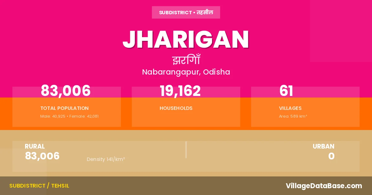
Jharigan is a town and Tehsil in the Nabarangapur district of the Odisha. In India, a Tehsil is a subdivision of a district responsible for the administration and revenue collection of a specific area within the district. Tehsils play a crucial role in the local governance structure, contributing significantly to the development and administration of their communities.
According to the 2011 census The total area of Jharigan Tehsil is 589 km², with a population of 83006 people. The population density is 141 inhabitants per square kilometre, and there are approximately 19162 houses in the sub district.
Jharigan Tehsil comprises about 61 villages. Below is a list of these villages along with information about their respective gram panchayats and the nearest town:
| # | Village Name | Gram Panchayat | Nearest Town |
|---|---|---|---|
| 1 | Badatemara | Badatemara | Umarkote (40 km) |
| 2 | Baharkarmari | Chakalapadar | Umarkote (39 km) |
| 3 | Bandiguda | Jharigam | Umarkote (20 km) |
| 4 | Banjiamba | Gurusingha | Umarkote (15 km) |
| 5 | Banuaguda | Banuaguda | Umarkote (23 km) |
| 6 | Barahaguda | Phupugam | Umarkote (29 km) |
| 7 | Barandipada | Jharigam | Umarkote (17 km) |
| 8 | Basudevguda | Palia | Umarkote (29 km) |
| 9 | Belgan | Belgam | Umarkote (25 km) |
| 10 | Beljhori | Palia | Umarkote (34 km) |
| 11 | Bhalukonadi | Phupugam | Umarkote (26 km) |
| 12 | Bhejiguda | Chacha | Umarkote (30 km) |
| 13 | Bhitarkarmari | Chakalapadar | Umarkote (60 km) |
| 14 | Bodoni | Palia | Umarkote (34 km) |
| 15 | Butisargi | Belgam | Umarkote (24 km) |
| 16 | Chaklapadar | Chakalapadar | Umarkote (33 km) |
| 17 | Chapakhana | Chakalapadar | Umarkote (36 km) |
| 18 | Chikili | Kutrichhapur | Umarkote (25 km) |
| 19 | Chitabeda | Chitabeda | Umarkote (30 km) |
| 20 | Chocha | Chacha | Umarkote (30 km) |
| 21 | Dahimal Ii | Chakalapadar | Umarkote (46 km) |
| 22 | Dehurakona | Banuaguda | Umarkote (24 km) |
| 23 | Dhanpur | Ekamba B | Umarkote (10 km) |
| 24 | Dukulikote | Chakalapadar | Umarkote (40 km) |
| 25 | Gobagoda | Chacha | Umarkote (30 km) |
| 26 | Gumioda | Banuaguda | Umarkote (25 km) |
| 27 | Gurusinga | Gurusingha | Umarkote (14 km) |
| 28 | Ichhapur | Chacha | Umarkote (27 km) |
| 29 | Jharigan | Jharigam | Umarkote (18 km) |
| 30 | Jobadhodi | Phupugam | Umarkote (26 km) |
| 31 | Junapani | Belgam | Umarkote (25 km) |
| 32 | Karmari | Belgam | Umarkote (13 km) |
| 33 | Karsahandi | Jharigam | Umarkote (22 km) |
| 34 | Kenduguda | Ratakhandiguda | Umarkote (25 km) |
| 35 | Kolegam | Kutrichhapur | Umarkote (22 km) |
| 36 | Kongora | Chakalapadar | Umarkote (38 km) |
| 37 | Kusumi | Gurusingha | Umarkote (13 km) |
| 38 | Kuturichapar | Kutrichhapur | Umarkote (20 km) |
| 39 | Lambidora | Telanadigam | Umarkote (14 km) |
| 40 | Lohandasil | Chakalapadar | Umarkote (42 km) |
| 41 | Mahandi | Belgam | Umarkote (12 km) |
| 42 | Nuagan | Gurusingha | Umarkote (35 km) |
| 43 | Nuaguda | Jharigam | Umarkote (17 km) |
| 44 | Palasagam | Banuaguda | Umarkote (26 km) |
| 45 | Palia | Palia | Umarkote (34 km) |
| 46 | Pandragandi | Chitabeda | Umarkote (25 km) |
| 47 | Paurbelli | Palia | Umarkote (29 km) |
| 48 | Phupugan | Phupugam | Umarkote (30 km) |
| 49 | Ramsa | Palia | Umarkote (33 km) |
| 50 | Ratakhandiguda | Ratakhandiguda | Umarkote (20 km) |
| 51 | Sanatemara | Badatemara | Umarkote (40 km) |
| 52 | Sarishabhata | Jharigam | Umarkote (17 km) |
| 53 | Sindhiguda | Banuaguda | Umarkote (17 km) |
| 54 | Sindikaguda | Medana | Umarkote (34 km) |
| 55 | Siunaguda | Chitabeda | Umarkote (20 km) |
| 56 | Sondosa | Chitabeda | Umarkote (30 km) |
| 57 | Taliamba | Jharigam | Umarkote (18 km) |
| 58 | Tarabeda | Chacha | Umarkote (30 km) |
| 59 | Tarakanari | Phupugam | Umarkote (28 km) |
| 60 | Telagan | Belgam | Umarkote (30 km) |
| 61 | Thatbeda | Chacha | Umarkote (25 km) |
The population is distributed between urban and rural areas as follows:
| Particulars | Rural | Urban | Total |
|---|---|---|---|
| Total Population | 83006 | 0 | 83006 |
| Male Population | 40925 | 0 | 40925 |
| Female Population | 42081 | 0 | 42081 | Population Density | 141 / km² | 141 / km² |
The distribution of households in the Jharigan is:
| Rural Households | Urban Households | Total Households |
|---|---|---|
| 19162 | 0 | 19162 |
Q: What is Jharigan?
A: Jharigan is a town and in the Nabarangapur district of the Odisha.
Q: What is the total area of Jharigan Tehsil?
A: The total area of Jharigan Tehsil is 589 km².
Q: What is the population of Jharigan Tehsil according to the 2011 census?
A: According to the 2011 census, the population of Jharigan Tehsil is 83006.
Q: What is the population density of Jharigan Tehsil?
A: The population density of Jharigan Tehsil is 141 inhabitants per square kilometre.
Q: How many houses are there in Jharigan Tehsil?
A: There are approximately 19162 houses in Jharigan Tehsil.
Q: How many villages are there in Jharigan Tehsil?
A: There are about 61 villages in Jharigan Tehsil.
Q: Which is the largest village by population in Jharigan Tehsil?
A: The largest village by population in Jharigan Tehsil is Jharigan, with 8463 people.
Q: Which is the smallest village by population in Jharigan Tehsil?
A: The smallest village by population in Jharigan Tehsil is Bandiguda, with 39 people.
Q: Which is the largest village by area in Jharigan Tehsil?
A: The largest village by area in Jharigan Tehsil is Ichhapur, with 1356 km².
Q: Which is the smallest village by area in Jharigan Tehsil?
A: The smallest village by area in Jharigan Tehsil is Bandiguda, with 21 km².
Q: What is the population distribution between urban and rural areas in Jharigan Tehsil?
A: The population distribution in Jharigan Tehsil is entirely rural, with a total rural population of 83006.
Q: What is the male population of Jharigan Tehsil?
A: The male population of Jharigan Tehsil is 40925.
Q: What is the female population of Jharigan Tehsil?
A: The female population of Jharigan Tehsil is 42081.
Q: How is the household distribution in Jharigan Tehsil?
A: The household distribution in Jharigan Tehsil is entirely rural, with a total of 19162 households.
Q: How many villages in Jharigan Tehsil have a population of less than 100?
A: There are 1 villages in Jharigan Tehsil with a population of less than 100.
Q: How many villages in Jharigan Tehsil have a population between 100 and 499?
A: There are 11 villages in Jharigan Tehsil with a population between 100 and 499.
Q: How many villages in Jharigan Tehsil have a population between 500 and 999?
A: There are 18 villages in Jharigan Tehsil with a population between 500 and 999.
Q: How many villages in Jharigan Tehsil have a population between 1000 and 1999?
A: There are 18 villages in Jharigan Tehsil with a population between 1000 and 1999.
Q: How many villages in Jharigan Tehsil have a population between 2000 and 2999?
A: There is 10 village in Jharigan Tehsil with a population between 2000 and 2999.
Q: How many villages in Jharigan Tehsil have a population between 3000 and 3999?
A: There is 1 village in Jharigan Tehsil with a population between 3000 and 3999.
Q: How many villages in Jharigan Tehsil have a population of 5000 and above?
A: There is 2 village in Jharigan Tehsil with a population of 5000 and above.
| Total Population | Villages in Sub District Of Jharigan |
|---|---|
| Less than 100 | 1 |
| 100-499 | 11 |
| 500-999 | 18 |
| 1000-1999 | 18 |
| 2000-2999 | 10 |
| 3000-3999 | 1 |
| 5000 And Above | 2 |