Tentulikhunti: A Town and Tehsil in Nabarangapur district
District → Nabarangapur
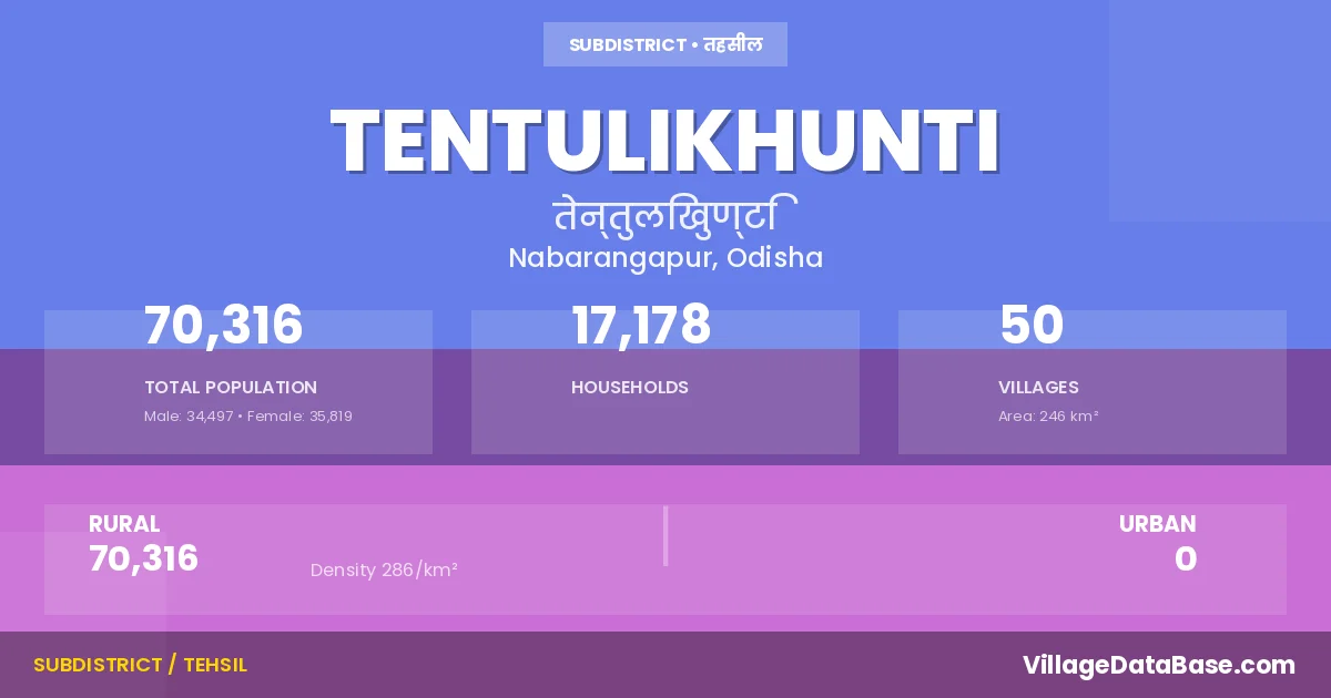
State → Odisha
Tentulikhunti is a town and Tehsil in the Nabarangapur district of the Odisha. In India, a Tehsil is a subdivision of a district responsible for the administration and revenue collection of a specific area within the district. Tehsils play a crucial role in the local governance structure, contributing significantly to the development and administration of their communities.
According to the 2011 census The total area of Tentulikhunti Tehsil is 246 km², with a population of 70316 people. The population density is 286 inhabitants per square kilometre, and there are approximately 17178 houses in the sub district.
Tentulikhunti Tehsil comprises about 50 villages. Below is a list of these villages along with information about their respective gram panchayats and the nearest town:
| # | Village Name | Gram Panchayat | Nearest Town |
|---|---|---|---|
| 1 | Anchala Guma | Anchalagumma | Nabarangapur (24 km) |
| 2 | Antasor | Dahana | Nabarangapur (18 km) |
| 3 | Aunlibhata | Amlabhatta | Nabarangapur (26 km) |
| 4 | Baragam | Mentri | Nabarangapur (20 km) |
| 5 | Bharanpur | Anchalagumma | Nabarangapur (24 km) |
| 6 | Charamula | Digi | Nabarangapur (30 km) |
| 7 | Dahana | Dahana | Nabarangapur (17 km) |
| 8 | Dangasil | Tentulikhunti | Nabarangapur (30 km) |
| 9 | Dhandra | Dhandra | Nabarangapur (10 km) |
| 10 | Digi | Digi | Nabarangapur (31 km) |
| 11 | Dukhuguda | Kangra | Nabarangapur (20 km) |
| 12 | Gudara | Patraput | Nabarangapur (39 km) |
| 13 | Hirimimunda | Anchalagumma | Nabarangapur (23 km) |
| 14 | Janiguda | Kangra | Nabarangapur (22 km) |
| 15 | Jharigumma | Jharigumma | Nabarangapur (31 km) |
| 16 | Kamata | Kamta | Nabarangapur (25 km) |
| 17 | Kanhai Munda | Lamtaguda | Nabarangapur (29 km) |
| 18 | Kantagam | Kantagam | Nabarangapur (23 km) |
| 19 | Karlichuan | Digi | Nabarangapur (24 km) |
| 20 | Khandia Guda | Tentulikhunti | Nabarangapur (27 km) |
| 21 | Khunti Padar | Pujariguda | Nabarangapur (22 km) |
| 22 | Kongra | Kangra | Nabarangapur (15 km) |
| 23 | Kurumakot | Pujariguda | Nabarangapur (22 km) |
| 24 | Kusumi | Kamta | Nabarangapur (24 km) |
| 25 | Lakadi Pala | Kangra | Nabarangapur (21 km) |
| 26 | Madagulumi | Tentulikhunti | Nabarangapur (29 km) |
| 27 | Mangardhara | Tentulikhunti | Nabarangapur (40 km) |
| 28 | Marali | Dahana | Nabarangapur (18 km) |
| 29 | Mengra | Patraput | Nabarangapur (24 km) |
| 30 | Mentri | Mentri | Nabarangapur (20 km) |
| 31 | Merakani | Tentulikhunti | Nabarangapur (38 km) |
| 32 | Meranas | Dahana | Nabarangapur (18 km) |
| 33 | Munda Guda | Tentulikhunti | Nabarangapur (34 km) |
| 34 | Nua Pujariguda | Patraput | Nabarangapur (24 km) |
| 35 | Nuagan | Dahana | Nabarangapur (18 km) |
| 36 | Olama | Kangra | Nabarangapur (20 km) |
| 37 | Panaspadar | Digi | Nabarangapur (30 km) |
| 38 | Pathanguda | Mentri | Nabarangapur (24 km) |
| 39 | Patharlasa | Dhandra | Nabarangapur (18 km) |
| 40 | Patrapur | Patraput | Nabarangapur (22 km) |
| 41 | Pitakumuli | Dhandra | Nabarangapur (16 km) |
| 42 | Pujariguda | Pujariguda | Nabarangapur (21 km) |
| 43 | Rasiaguda | Nandahandi | Nabarangapur (16 km) |
| 44 | Salapa | Digi | Nabarangapur (25 km) |
| 45 | Tabha Padar | Tentulikhunti | Nabarangapur (40 km) |
| 46 | Tentulikhunti | Tentulikhunti | Nabarangapur (23 km) |
| 47 | Timanpur | Patraput | Nabarangapur (20 km) |
| 48 | Turunji | Dhandra | Nabarangapur (19 km) |
| 49 | Udayapur | Tentulikhunti | Nabarangapur (22 km) |
| 50 | Umuri | Anchalagumma | Nabarangapur (23 km) |
The population is distributed between urban and rural areas as follows:
| Particulars | Rural | Urban | Total |
|---|---|---|---|
| Total Population | 70316 | 0 | 70316 |
| Male Population | 34497 | 0 | 34497 |
| Female Population | 35819 | 0 | 35819 | Population Density | 286 / km² | 286 / km² |
The distribution of households in the Tentulikhunti is:
| Rural Households | Urban Households | Total Households |
|---|---|---|
| 17178 | 0 | 17178 |
Q: What is Tentulikhunti?
A: Tentulikhunti is a town and in the Nabarangapur district of the Odisha.
Q: What is the total area of Tentulikhunti Tehsil?
A: The total area of Tentulikhunti Tehsil is 246 km².
Q: What is the population of Tentulikhunti Tehsil according to the 2011 census?
A: According to the 2011 census, the population of Tentulikhunti Tehsil is 70316.
Q: What is the population density of Tentulikhunti Tehsil?
A: The population density of Tentulikhunti Tehsil is 286 inhabitants per square kilometre.
Q: How many houses are there in Tentulikhunti Tehsil?
A: There are approximately 17178 houses in Tentulikhunti Tehsil.
Q: How many villages are there in Tentulikhunti Tehsil?
A: There are about 50 villages in Tentulikhunti Tehsil.
Q: Which is the largest village by population in Tentulikhunti Tehsil?
A: The largest village by population in Tentulikhunti Tehsil is Jharigumma, with 4436 people.
Q: Which is the smallest village by population in Tentulikhunti Tehsil?
A: The smallest village by population in Tentulikhunti Tehsil is Munda Guda, with 114 people.
Q: Which is the largest village by area in Tentulikhunti Tehsil?
A: The largest village by area in Tentulikhunti Tehsil is Jharigumma, with 2309 km².
Q: Which is the smallest village by area in Tentulikhunti Tehsil?
A: The smallest village by area in Tentulikhunti Tehsil is Nua Pujariguda, with 19 km².
Q: What is the population distribution between urban and rural areas in Tentulikhunti Tehsil?
A: The population distribution in Tentulikhunti Tehsil is entirely rural, with a total rural population of 70316.
Q: What is the male population of Tentulikhunti Tehsil?
A: The male population of Tentulikhunti Tehsil is 34497.
Q: What is the female population of Tentulikhunti Tehsil?
A: The female population of Tentulikhunti Tehsil is 35819.
Q: How is the household distribution in Tentulikhunti Tehsil?
A: The household distribution in Tentulikhunti Tehsil is entirely rural, with a total of 17178 households.
Q: How many villages in Tentulikhunti Tehsil have a population between 100 and 499?
A: There are 9 villages in Tentulikhunti Tehsil with a population between 100 and 499.
Q: How many villages in Tentulikhunti Tehsil have a population between 500 and 999?
A: There are 13 villages in Tentulikhunti Tehsil with a population between 500 and 999.
Q: How many villages in Tentulikhunti Tehsil have a population between 1000 and 1999?
A: There are 16 villages in Tentulikhunti Tehsil with a population between 1000 and 1999.
Q: How many villages in Tentulikhunti Tehsil have a population between 2000 and 2999?
A: There is 7 village in Tentulikhunti Tehsil with a population between 2000 and 2999.
Q: How many villages in Tentulikhunti Tehsil have a population between 3000 and 3999?
A: There is 3 village in Tentulikhunti Tehsil with a population between 3000 and 3999.
Q: How many villages in Tentulikhunti Tehsil have a population between 4000 and 4999?
A: There is 2 village in Tentulikhunti Tehsil with a population between 4000 and 4999.
| Total Population | Villages in Sub District Of Tentulikhunti |
|---|---|
| 100-499 | 9 |
| 500-999 | 13 |
| 1000-1999 | 16 |
| 2000-2999 | 7 |
| 3000-3999 | 3 |
| 4000-4999 | 2 |