District → Nayagarh
State → Odisha
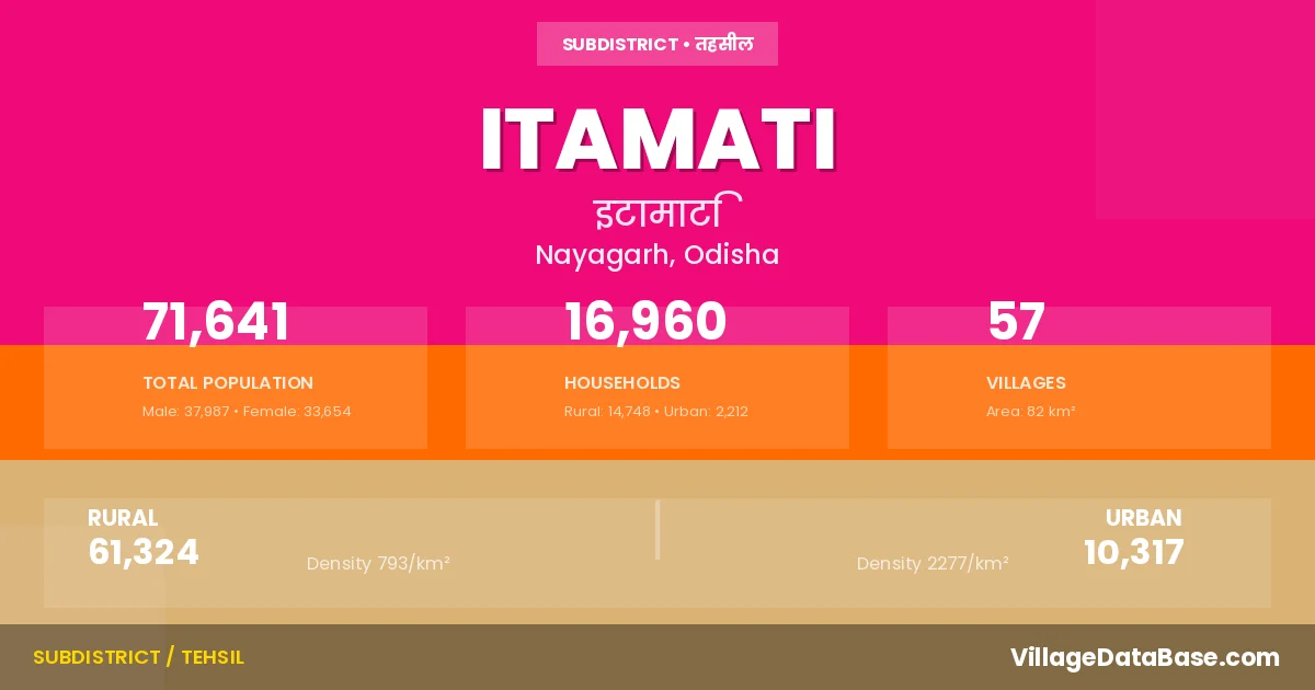
Itamati is a town and Tehsil in the Nayagarh district of the Odisha. In India, a Tehsil is a subdivision of a district responsible for the administration and revenue collection of a specific area within the district. Tehsils play a crucial role in the local governance structure, contributing significantly to the development and administration of their communities.
According to the 2011 census The total area of Itamati Tehsil is 82 km², with a population of 71641 people. The population density is 875 inhabitants per square kilometre, and there are approximately 16960 houses in the sub district.
Itamati Tehsil comprises about 57 villages. Below is a list of these villages along with information about their respective gram panchayats and the nearest town:
| # | Village Name | Gram Panchayat | Nearest Town |
|---|---|---|---|
| 1 | Adabandh | Ikiri | Nayagarh (13 km) |
| 2 | Arjunpur | Saranakul | Nayagarh (10 km) |
| 3 | Badapandusar | Badapandusara | Nayagarh (6 km) |
| 4 | Baghara | Biruda | Nayagarh (10 km) |
| 5 | Balikudia | Gadadharaprasad | Nayagarh (7 km) |
| 6 | Banamalipur | Saranakul | Nayagarh (12 km) |
| 7 | Barabanka | Saradhapur | Nayagarh (8 km) |
| 8 | Barbati | Laxmiprasad | Nayagarh (6 km) |
| 9 | Baunsiapada | Baunsiapada | Nayagarh (9 km) |
| 10 | Bijipur | Saranakul | Nayagarh (10 km) |
| 11 | Biruda | Biruda | Nayagarh (10 km) |
| 12 | Champatipur | Champatipur | Nayagarh (10 km) |
| 13 | Chandrasekharpur | Gambharidhi | Nayagarh (10 km) |
| 14 | Damodarpur | Saradhapur | Nayagarh (8 km) |
| 15 | Dengeragodi | Itamati | Nayagarh (6 km) |
| 16 | Deuliamrutmanohi | Gambharidhi | Nayagarh (13 km) |
| 17 | Gadadharprasad | Gadadharaprasad | Nayagarh (7 km) |
| 18 | Gambharidihi | Gambharidhi | Nayagarh (10 km) |
| 19 | Gobindpur | Gadadharaprasad | Nayagarh (8 km) |
| 20 | Godikhol | Biruda | Nayagarh (14 km) |
| 21 | Gopalpur | Saranakul | Nayagarh (10 km) |
| 22 | Harekrushnapur | Badapandusara | Nayagarh (7 km) |
| 23 | Haripur | Haripur | Nayagarh (6 km) |
| 24 | Ikiri | Ikiri | Nayagarh (12 km) |
| 25 | Itamati | Itamati | Itamati |
| 26 | Jaganathpur | Saranakul | Nayagarh (10 km) |
| 27 | Jamusahi | Khuntubandha | Nayagarh (13 km) |
| 28 | Jharpada | Biruda | Nayagarh (10 km) |
| 29 | Kautara | Saranakul | Nayagarh (10 km) |
| 30 | Khairpati | Ikiri | Nayagarh (15 km) |
| 31 | Khedaberana | Natugaon | Nayagarh (13 km) |
| 32 | Krushnadeipur | Gambharidhi | Nayagarh (10 km) |
| 33 | Krushnaprasad | Lathipada | Nayagarh (6 km) |
| 34 | Lathipada | Lathipada | Nayagarh (8 km) |
| 35 | Melamba | Saradhapur | Nayagarh (9 km) |
| 36 | Mrutyunjaypur | Badapandusara | Nayagarh (7 km) |
| 37 | Nachhipur | Ikiri | Nayagarh (14 km) |
| 38 | Nagapur | Lathipada | Nayagarh (2 km) |
| 39 | Nandapur | Gambharidhi | Nayagarh (12 km) |
| 40 | Natugaon | Natugaon | Nayagarh (11 km) |
| 41 | Nuagaon | Ikiri | Nayagarh (9 km) |
| 42 | Patachandiprasad | Baunsiapada | Nayagarh (8 km) |
| 43 | Pelagunthuni | Natugaon | Nayagarh (30 km) |
| 44 | Pratapprasad | Itamati | Nayagarh (4 km) |
| 45 | Pursotampur | Baunsiapada | Nayagarh (7 km) |
| 46 | Sajanapada | Natugaon | Nayagarh (12 km) |
| 47 | Saluni | Natugaon | Nayagarh (8 km) |
| 48 | Sanapandusar | Badapandusara | Nayagarh (10 km) |
| 49 | Saradhapur | Saradhapur | Nayagarh (9 km) |
| 50 | Sarankul Oraf Jahnipada | Saranakul | Nayagarh (10 km) |
| 51 | Sarapada | Badapandusara | Nayagarh (10 km) |
| 52 | Shyamaghanapur | Saranakul | Nayagarh (10 km) |
| 53 | Subalaya | Natugaon | Nayagarh (12 km) |
| 54 | Sukalagadia | Gadadharaprasad | Nayagarh (6 km) |
| 55 | Sunanati | Badapandusara | Nayagarh (10 km) |
| 56 | Tentuliapalli | Ikiri | Nayagarh (13 km) |
| 57 | Tipura | Ikiri | Nayagarh (15 km) |
The population is distributed between urban and rural areas as follows:
| Particulars | Rural | Urban | Total |
|---|---|---|---|
| Total Population | 61324 | 10317 | 71641 |
| Male Population | 32591 | 5396 | 37987 |
| Female Population | 28733 | 4921 | 33654 | Population Density | 793 / km² | 2277 / km² | 875 / km² |
The distribution of households in the Itamati is:
| Rural Households | Urban Households | Total Households |
|---|---|---|
| 14748 | 2212 | 16960 |
Q: What is Itamati?
A: Itamati is a town and in the Nayagarh district of the Odisha.
Q: What is the total area of Itamati Tehsil?
A: The total area of Itamati Tehsil is 82 km².
Q: What is the population of Itamati Tehsil according to the 2011 census?
A: According to the 2011 census, the population of Itamati Tehsil is 71641.
Q: What is the population density of Itamati Tehsil?
A: The population density of Itamati Tehsil is 875 inhabitants per square kilometre.
Q: How many houses are there in Itamati Tehsil?
A: There are approximately 16960 houses in Itamati Tehsil.
Q: How many villages are there in Itamati Tehsil?
A: There are about 57 villages in Itamati Tehsil.
Q: Which is the largest village by population in Itamati Tehsil?
A: The largest village by population in Itamati Tehsil is Lathipada, with 5945 people.
Q: Which is the smallest village by population in Itamati Tehsil?
A: The smallest village by population in Itamati Tehsil is Arjunpur, with 0 people.
Q: Which is the largest village by area in Itamati Tehsil?
A: The largest village by area in Itamati Tehsil is Baunsiapada, with 598 km².
Q: Which is the smallest village by area in Itamati Tehsil?
A: The smallest village by area in Itamati Tehsil is Itamati, with 0 km².
Q: What is the male population of Itamati Tehsil?
A: The male population of Itamati Tehsil is 37987.
Q: What is the female population of Itamati Tehsil?
A: The female population of Itamati Tehsil is 33654.
Q: How many villages in Itamati Tehsil have a population of less than 100?
A: There are 6 villages in Itamati Tehsil with a population of less than 100.
Q: How many villages in Itamati Tehsil have a population between 100 and 499?
A: There are 11 villages in Itamati Tehsil with a population between 100 and 499.
Q: How many villages in Itamati Tehsil have a population between 500 and 999?
A: There are 23 villages in Itamati Tehsil with a population between 500 and 999.
Q: How many villages in Itamati Tehsil have a population between 1000 and 1999?
A: There are 11 villages in Itamati Tehsil with a population between 1000 and 1999.
Q: How many villages in Itamati Tehsil have a population between 3000 and 3999?
A: There is 2 village in Itamati Tehsil with a population between 3000 and 3999.
Q: How many villages in Itamati Tehsil have a population between 4000 and 4999?
A: There is 3 village in Itamati Tehsil with a population between 4000 and 4999.
Q: How many villages in Itamati Tehsil have a population of 5000 and above?
A: There is 1 village in Itamati Tehsil with a population of 5000 and above.
| Total Population | Villages in Sub District Of Itamati |
|---|---|
| Less than 100 | 6 |
| 100-499 | 11 |
| 500-999 | 23 |
| 1000-1999 | 11 |
| 3000-3999 | 2 |
| 4000-4999 | 3 |
| 5000 And Above | 1 |