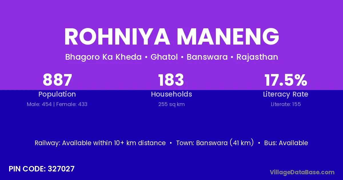
Rohniya Maneng village is located in the Ghatol Tehsil of the Banswara district in Rajasthan .
Block / Tehsil → Ghatol
District → Banswara
State → Rajasthan
According to Census 2011 information, the village code of Rohniya Maneng village is 327027.
Rohniya Maneng village has a total population of 887 people, of which 454 are males and 433 are females.
The literacy rate of Rohniya Maneng village is 17.47%. Male literacy stands at 24.23% and female literacy at 10.39%.
There are approximately 183 households in Rohniya Maneng village.
Banswara (41 km) is the nearest town to Rohniya Maneng village for major economic activities and is located approximately 41 km away.
The population of Rohniya Maneng village is distributed between literate and illiterate residents as follows:
| Particulars | Male | Female | Total |
|---|---|---|---|
| Literate | 110 | 45 | 155 |
| Illiterate | 344 | 388 | 732 |
| Total | 454 | 433 | 887 |
Source: Census 2011
| Village | District |
|---|---|
| Bansri Khera | Banswara |
| Borpi Kereng | Banswara |
| Chundai | Banswara |
| Doongar | Banswara |
| Doongar | Banswara |
| Doongar | Dungarpur |
| Hameergarh | Banswara |
| Harmatiya | Banswara |
| Harmatiya | Banswara |
| Harmatiya | Banswara |
| Harmatiya | Banswara |
| Harmatiya | Chittaurgarh |
| Harmatiya | Dungarpur |
| Kuni Ka Ara | Banswara |
| Lod | Ratlam |
| Lod | Banswara |
| Mahapura Rathor | Banswara |
| Roopji Ka Khera | Banswara |
| Todi Simrol | Banswara |
No reviews yet. Be the first to review this village!
Available within 10+ km distance
Available within <5 km distance
Available within <5 km distance