Rashmi: A Town and Tehsil in Chittaurgarh district
District → Chittaurgarh
State → Rajasthan
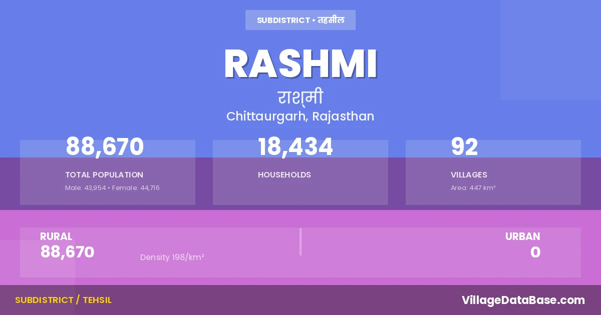
Rashmi is a town and Tehsil in the Chittaurgarh district of the Rajasthan. In India, a Tehsil is a subdivision of a district responsible for the administration and revenue collection of a specific area within the district. Tehsils play a crucial role in the local governance structure, contributing significantly to the development and administration of their communities.
According to the 2011 census The total area of Rashmi Tehsil is 447 km², with a population of 88670 people. The population density is 198 inhabitants per square kilometre, and there are approximately 18434 houses in the sub district.
Rashmi Tehsil comprises about 92 villages. Below is a list of these villages along with information about their respective gram panchayats and the nearest town:
| # | Village Name | Gram Panchayat | Nearest Town |
|---|---|---|---|
| 1 | Achalpura | Harnathpura | Kapasan (20 km) |
| 2 | Adana | Adana | Kapasan (25 km) |
| 3 | Arni | Arni | Kapasan (35 km) |
| 4 | Bakhatawar Pura | Somi | Kapasan (30 km) |
| 5 | Balwantpura | Lasadiya Kalan | Gangapur (22 km) |
| 6 | Baroo | Baroo | Chittaurgarh (30 km) |
| 7 | Bassi | Lasadiya Kalan | Bhilwara (32 km) |
| 8 | Bawlas | Bawlas | Chittaurgarh (32 km) |
| 9 | Bhalotan Ki Kheri | Bhalotan Ki Kheri | Bhilwara (35 km) |
| 10 | Bhat Kheri | Baroo | Chittaurgarh (29 km) |
| 11 | Bheemgarh | Bheemgarh | Kapasan (30 km) |
| 12 | Bhopalpura | Arni | Kapasan (25 km) |
| 13 | Bhoplai | Pavli | Kapasan (25 km) |
| 14 | Chak Adana No A | Adana | Kapasan (25 km) |
| 15 | Chak Adana No B | Adana | Kapasan (25 km) |
| 16 | Chamanpura | Dindoli | Kapasan (20 km) |
| 17 | Chatawati | Adana | Kapasan (25 km) |
| 18 | Chittauriya | Somarwalon Ka Khera | Kapasan (8 km) |
| 19 | Darba | Bhalotan Ki Kheri | Bhilwara (35 km) |
| 20 | Depura | Harnathpura | Kapasan (20 km) |
| 21 | Devipura | Somarwalon Ka Khera | Kapasan (30 km) |
| 22 | Devipura B | Kapasan (30 km) | |
| 23 | Devpuri | Somi | Kapasan (24 km) |
| 24 | Devpuriya | Lasadiya Kalan | Kapasan (17 km) |
| 25 | Dhangaliya Khera | Baroo | Chittaurgarh (29 km) |
| 26 | Dindoli | Dindoli | Kapasan (20 km) |
| 27 | Dolatpura | Baroo | Chittaurgarh (25 km) |
| 28 | Gandraf | Harnathpura | Kapasan (20 km) |
| 29 | Ganeshpura | Dindoli | Bhilwara (35 km) |
| 30 | Gegpura | Somi | Kapasan (30 km) |
| 31 | Gokalpura | Marmi | Kapasan (35 km) |
| 32 | Gopalpura Kalan | Arni | Kapasan (40 km) |
| 33 | Gopalpura Khurd | Arni | Gangapur (20 km) |
| 34 | Gudaliya | Rewara | Kapasan (33 km) |
| 35 | Gurjaniya | Harnathpura | Kapasan (20 km) |
| 36 | Hamerpura | Marmi | Kapasan (35 km) |
| 37 | Haripura | Adana | Kapasan (25 km) |
| 38 | Harnathpura | Harnathpura | Kapasan (28 km) |
| 39 | Heera Kheri | Uncha | Kapasan (35 km) |
| 40 | Indanpura | Bhalotan Ki Kheri | Bhilwara (33 km) |
| 41 | Jadana | Jadana | Kapasan (35 km) |
| 42 | Jagpura | Rood | Chittaurgarh (35 km) |
| 43 | Jalampura | Marmi | Chittaurgarh (45 km) |
| 44 | Jawaharpura | Adana | Kapasan (27 km) |
| 45 | Jawanpura | Adana | Kapasan (27 km) |
| 46 | Kanpura | Somarwalon Ka Khera | Kapasan (15 km) |
| 47 | Karas | Rewara | Kapasan (35 km) |
| 48 | Kareethara | Pavli | Kapasan (25 km) |
| 49 | Karjiya | Sankhli | Kapasan (30 km) |
| 50 | Keeron Ka Khera | Somi | Kapasan (30 km) |
| 51 | Lalpura | Sankhli | Kapasan (35 km) |
| 52 | Lasadiya Kalan | Lasadiya Kalan | Gangapur (24 km) |
| 53 | Lasadiya Khurd | Jadana | Kapasan (37 km) |
| 54 | Lookdi | Newariya | Bhilwara (28 km) |
| 55 | Mandpiya Mataji Ka | Newariya | Bhilwara (28 km) |
| 56 | Manyas | Sankhli | Kapasan (33 km) |
| 57 | Marmi | Marmi | Kapasan (32 km) |
| 58 | Matrikundiya | Harnathpura | Kapasan (30 km) |
| 59 | Meda Kheri | Sihana | Bhilwara (33 km) |
| 60 | Mirchiya Kheri | Bawlas | Chittaurgarh (32 km) |
| 61 | Muroli | Upreda | Kapasan (32 km) |
| 62 | Nandpura | Bhilwara (35 km) | |
| 63 | Nangpura | Somarwalon Ka Khera | Kapasan (15 km) |
| 64 | Narayanpura | Pavli | Kapasan (28 km) |
| 65 | Nawalpura | Harnathpura | Kapasan (18 km) |
| 66 | Newariya | Newariya | Bhilwara (28 km) |
| 67 | Pahoona | Pahoona | Bhilwara (35 km) |
| 68 | Pahooni | Rewara | Kapasan (30 km) |
| 69 | Panna Khera | Upreda | Kapasan (26 km) |
| 70 | Parmeshwar Pura | Somarwalon Ka Khera | Kapasan (18 km) |
| 71 | Pavli | Pavli | Kapasan (25 km) |
| 72 | Punawta | Bawlas | Chittaurgarh (30 km) |
| 73 | Puthwadia | Upreda | Kapasan (25 km) |
| 74 | Raipuriya | Bheemgarh | Kapasan (25 km) |
| 75 | Rampuriya | Lasadiya Kalan | Bhilwara (38 km) |
| 76 | Rashmi | Rashmi | Kapasan (25 km) |
| 77 | Ratan Kheri | Uncha | Bhilwara (34 km) |
| 78 | Ratna Ka Khera | Bawlas | Chittaurgarh (30 km) |
| 79 | Rewara | Rewara | Kapasan (40 km) |
| 80 | Rood | Rood | Chittaurgarh (30 km) |
| 81 | Rooppura | Lasadiya Kalan | Kapasan (37 km) |
| 82 | Rughnathpura | Adana | Kapasan (25 km) |
| 83 | Sankhli | Sankhli | Kapasan (31 km) |
| 84 | Sanwalpura | Adana | Chittaurgarh (42 km) |
| 85 | Shambhupura | Gangapur (24 km) | |
| 86 | Sihana | Sihana | Bhilwara (33 km) |
| 87 | Soliya | Newariya | Bhilwara (26 km) |
| 88 | Somarwalon Ka Khera | Somarwalon Ka Khera | Kapasan (15 km) |
| 89 | Somi | Somi | Kapasan (30 km) |
| 90 | Uncha | Uncha | Bhilwara (39 km) |
| 91 | Upreda | Upreda | Kapasan (28 km) |
| 92 | Uttampura | Arni | Kapasan (37 km) |
The population is distributed between urban and rural areas as follows:
| Particulars | Rural | Urban | Total |
|---|---|---|---|
| Total Population | 88670 | 0 | 88670 |
| Male Population | 43954 | 0 | 43954 |
| Female Population | 44716 | 0 | 44716 | Population Density | 198 / km² | 198 / km² |
The distribution of households in the Rashmi is:
| Rural Households | Urban Households | Total Households |
|---|---|---|
| 18434 | 0 | 18434 |
Q: What is Rashmi?
A: Rashmi is a town and in the Chittaurgarh district of the Rajasthan.
Q: What is the total area of Rashmi Tehsil?
A: The total area of Rashmi Tehsil is 447 km².
Q: What is the population of Rashmi Tehsil according to the 2011 census?
A: According to the 2011 census, the population of Rashmi Tehsil is 88670.
Q: What is the population density of Rashmi Tehsil?
A: The population density of Rashmi Tehsil is 198 inhabitants per square kilometre.
Q: How many houses are there in Rashmi Tehsil?
A: There are approximately 18434 houses in Rashmi Tehsil.
Q: How many villages are there in Rashmi Tehsil?
A: There are about 92 villages in Rashmi Tehsil.
Q: Which is the largest village by population in Rashmi Tehsil?
A: The largest village by population in Rashmi Tehsil is Rashmi, with 4923 people.
Q: Which is the smallest village by population in Rashmi Tehsil?
A: The smallest village by population in Rashmi Tehsil is Achalpura, with 0 people.
Q: Which is the largest village by area in Rashmi Tehsil?
A: The largest village by area in Rashmi Tehsil is Arni, with 1841 km².
Q: Which is the smallest village by area in Rashmi Tehsil?
A: The smallest village by area in Rashmi Tehsil is Chak Adana No A, with 8 km².
Q: What is the population distribution between urban and rural areas in Rashmi Tehsil?
A: The population distribution in Rashmi Tehsil is entirely rural, with a total rural population of 88670.
Q: What is the male population of Rashmi Tehsil?
A: The male population of Rashmi Tehsil is 43954.
Q: What is the female population of Rashmi Tehsil?
A: The female population of Rashmi Tehsil is 44716.
Q: How is the household distribution in Rashmi Tehsil?
A: The household distribution in Rashmi Tehsil is entirely rural, with a total of 18434 households.
Q: How many villages in Rashmi Tehsil have a population of less than 100?
A: There are 13 villages in Rashmi Tehsil with a population of less than 100.
Q: How many villages in Rashmi Tehsil have a population between 100 and 499?
A: There are 29 villages in Rashmi Tehsil with a population between 100 and 499.
Q: How many villages in Rashmi Tehsil have a population between 500 and 999?
A: There are 20 villages in Rashmi Tehsil with a population between 500 and 999.
Q: How many villages in Rashmi Tehsil have a population between 1000 and 1999?
A: There are 17 villages in Rashmi Tehsil with a population between 1000 and 1999.
Q: How many villages in Rashmi Tehsil have a population between 2000 and 2999?
A: There is 9 village in Rashmi Tehsil with a population between 2000 and 2999.
Q: How many villages in Rashmi Tehsil have a population between 3000 and 3999?
A: There is 1 village in Rashmi Tehsil with a population between 3000 and 3999.
Q: How many villages in Rashmi Tehsil have a population between 4000 and 4999?
A: There is 3 village in Rashmi Tehsil with a population between 4000 and 4999.
| Total Population | Villages in Sub District Of Rashmi |
|---|---|
| Less than 100 | 13 |
| 100-499 | 29 |
| 500-999 | 20 |
| 1000-1999 | 17 |
| 2000-2999 | 9 |
| 3000-3999 | 1 |
| 4000-4999 | 3 |