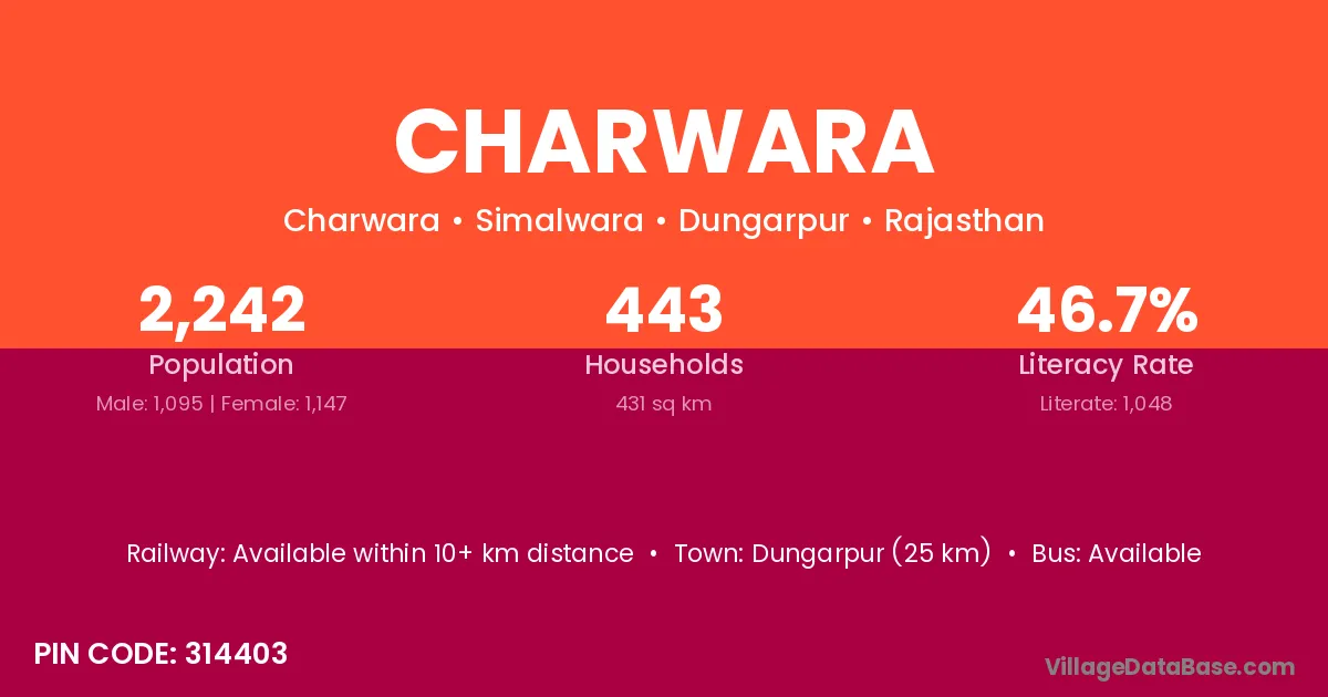
Charwara village is located in the Simalwara Tehsil of the Dungarpur district in Rajasthan .
Block / Tehsil → Simalwara
District → Dungarpur
State → Rajasthan
According to Census 2011 information, the village code of Charwara village is 314403.
Charwara village has a total population of 2,242 people, of which 1,095 are males and 1,147 are females.
The literacy rate of Charwara village is 46.74%. Male literacy stands at 54.89% and female literacy at 38.97%.
There are approximately 443 households in Charwara village.
Dungarpur (25 km) is the nearest town to Charwara village for major economic activities and is located approximately 25 km away.
The population of Charwara village is distributed between literate and illiterate residents as follows:
| Particulars | Male | Female | Total |
|---|---|---|---|
| Literate | 601 | 447 | 1,048 |
| Illiterate | 494 | 700 | 1,194 |
| Total | 1,095 | 1,147 | 2,242 |
Source: Census 2011
| Village | District |
|---|---|
| Annapura | Chikmagalur |
| Annapura | Davanagere |
| Annapura | Hassan |
| Annapura | Tumkur |
| Annapura | Dungarpur |
| Ariwat | Dungarpur |
| Ariwat | Dungarpur |
| Balwaniya | Dungarpur |
| Bhayta | Dungarpur |
| Bheenda | Dungarpur |
| Bilpan | Sabar Kantha |
| Bilpan | Sehore |
| Bilpan | Dungarpur |
| Bilpan | Dungarpur |
| Ghora Khara | Dungarpur |
| Kumela | Dungarpur |
| Mordoongra | Dungarpur |
| Pohri Khaturat | Dungarpur |
| Suroka Talab | Dungarpur |
No reviews yet. Be the first to review this village!
Available within 10+ km distance
Available within village
Available within village