District → Pali
State → Rajasthan
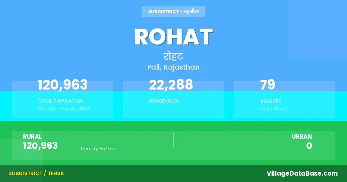
Rohat is a town and Tehsil in the Pali district of the Rajasthan. In India, a Tehsil is a subdivision of a district responsible for the administration and revenue collection of a specific area within the district. Tehsils play a crucial role in the local governance structure, contributing significantly to the development and administration of their communities.
According to the 2011 census The total area of Rohat Tehsil is 1430 km², with a population of 120963 people. The population density is 85 inhabitants per square kilometre, and there are approximately 22288 houses in the sub district.
Rohat Tehsil comprises about 79 villages. Below is a list of these villages along with information about their respective gram panchayats and the nearest town:
| # | Village Name | Gram Panchayat | Nearest Town |
|---|---|---|---|
| 1 | Antan | Sanwalta Kalan | Pali (47 km) |
| 2 | Aratiya | Bhakriwala | Pali (35 km) |
| 3 | Bandai | Chotila | Pali (20 km) |
| 4 | Bassi | Vayad | Pali (45 km) |
| 5 | Beenja | Vayad | Pali (45 km) |
| 6 | Beethoo | Bithoo | Pali (30 km) |
| 7 | Bhakriwala | Bhakriwala | Pali (25 km) |
| 8 | Bhinder | Kulthana | Pali (38 km) |
| 9 | Bhooriyasani | Kalali | Pali (43 km) |
| 10 | Chamundanagar | Kalali | Pali (40 km) |
| 11 | Chatelao | Bithoo | Pali (23 km) |
| 12 | Chenda | Chenda | Pali (48 km) |
| 13 | Chotila | Chotila | Pali (20 km) |
| 14 | Dalpatgarh | Rohat | Pali (28 km) |
| 15 | Danasani | Chotila | Pali (34 km) |
| 16 | Dewan | Kulthana | Pali (50 km) |
| 17 | Dhabar | Dhabar | Pali (16 km) |
| 18 | Dharamdhari | Chotila | Pali (30 km) |
| 19 | Dhingana | Kulthana | Pali (50 km) |
| 20 | Dholeriya Jagir | Dholeriya Sasan | Pali (35 km) |
| 21 | Dholeriya Sasan | Dholeriya Sasan | Pali (36 km) |
| 22 | Dhundali | Rohat | Pali (37 km) |
| 23 | Diwandi | Diwandi | Pali (56 km) |
| 24 | Doodali | Singari | Pali (33 km) |
| 25 | Doodiya | Dhabar | Pali (16 km) |
| 26 | Dungar Pur | Khandi | Pali (42 km) |
| 27 | Gajangarh | Kharda | Pali (22 km) |
| 28 | Garwaliya | Gadhwara | Pali (35 km) |
| 29 | Garwara | Gadhwara | Pali (30 km) |
| 30 | Gelawas | Gelawas | Pali (60 km) |
| 31 | Hanjawa | Chenda | Pali (50 km) |
| 32 | Heerawas | Khandi | Pali (51 km) |
| 33 | Indrokon Ki Dhani | Jheetra | Pali (20 km) |
| 34 | Jaitpur | Gadhwara | Pali (30 km) |
| 35 | Jheetra | Jheetra | Pali (27 km) |
| 36 | Kala Pipal Ki Dhani | Jheetra | Pali (22 km) |
| 37 | Kalali | Kalali | Pali (39 km) |
| 38 | Kanawas | Dhabar | Pali (14 km) |
| 39 | Khandi | Khandi | Pali (47 km) |
| 40 | Kharda | Kharda | Pali (18 km) |
| 41 | Khundawas | Khundawas | Pali (36 km) |
| 42 | Khutani | Diwandi | Pali (50 km) |
| 43 | Kulthana | Kulthana | Pali (40 km) |
| 44 | Kundli Charnan | Kulthana | Pali (44 km) |
| 45 | Lalki | Kalali | Pali (40 km) |
| 46 | Lambra | Gelawas | Pali (54 km) |
| 47 | Madpuriya | Jheetra | Pali (25 km) |
| 48 | Malwa | Khundawas | Pali (40 km) |
| 49 | Mandawas | Mandawas | Pali (45 km) |
| 50 | Mandli Darjiyan | Bhakriwala | Pali (35 km) |
| 51 | Moriya | Singari | Pali (30 km) |
| 52 | Mukanpura | Chotila | Pali (20 km) |
| 53 | Murdiya | Diwandi | Pali (50 km) |
| 54 | Neembli Bramnan | Rohat | Pali (37 km) |
| 55 | Neembli Patelan | Rohat | Pali (40 km) |
| 56 | Nehra | Dholeriya Sasan | Pali (39 km) |
| 57 | Panch Padariya | Gelawas | Pali (70 km) |
| 58 | Pati | Chenda | Pali (50 km) |
| 59 | Peepaliya Ki Dhani | Jheetra | Pali (30 km) |
| 60 | Phenkariya | Dholeriya Sasan | Pali (44 km) |
| 61 | Pukhtari | Gelawas | Pali (63 km) |
| 62 | Rakhana | Kulthana | Pali (44 km) |
| 63 | Rampura | Kalali | Pali (34 km) |
| 64 | Rana | Rana | Pali (34 km) |
| 65 | Reoda Khurd | Gelawas | Pali (73 km) |
| 66 | Rohat | Rohat | Pali (31 km) |
| 67 | Saji | Sonailakha | Pali (41 km) |
| 68 | Sajianpura | Sonailakha | Pali (37 km) |
| 69 | Sanwalta Kalan | Sanwalta Kalan | Pali (47 km) |
| 70 | Sanwalta Khurd | Sanwalta Kalan | Pali (33 km) |
| 71 | Sawaipura | Chotila | Pali (18 km) |
| 72 | Sedariya | Khundawas | Pali (42 km) |
| 73 | Singari | Singari | Pali (37 km) |
| 74 | Sirana | Chenda | Pali (50 km) |
| 75 | Sonailakha | Sonailakha | Pali (35 km) |
| 76 | Sukarlai | Khundawas | Pali (23 km) |
| 77 | Umkali | Kulthana | Pali (42 km) |
| 78 | Undra | Vayad | Pali (40 km) |
| 79 | Vayad | Vayad | Pali (42 km) |
The population is distributed between urban and rural areas as follows:
| Particulars | Rural | Urban | Total |
|---|---|---|---|
| Total Population | 120963 | 0 | 120963 |
| Male Population | 62111 | 0 | 62111 |
| Female Population | 58852 | 0 | 58852 | Population Density | 85 / km² | 85 / km² |
The distribution of households in the Rohat is:
| Rural Households | Urban Households | Total Households |
|---|---|---|
| 22288 | 0 | 22288 |
Q: What is Rohat?
A: Rohat is a town and in the Pali district of the Rajasthan.
Q: What is the total area of Rohat Tehsil?
A: The total area of Rohat Tehsil is 1430 km².
Q: What is the population of Rohat Tehsil according to the 2011 census?
A: According to the 2011 census, the population of Rohat Tehsil is 120963.
Q: What is the population density of Rohat Tehsil?
A: The population density of Rohat Tehsil is 85 inhabitants per square kilometre.
Q: How many houses are there in Rohat Tehsil?
A: There are approximately 22288 houses in Rohat Tehsil.
Q: How many villages are there in Rohat Tehsil?
A: There are about 79 villages in Rohat Tehsil.
Q: Which is the largest village by population in Rohat Tehsil?
A: The largest village by population in Rohat Tehsil is Rohat, with 6980 people.
Q: Which is the smallest village by population in Rohat Tehsil?
A: The smallest village by population in Rohat Tehsil is Kundli Charnan, with 63 people.
Q: Which is the largest village by area in Rohat Tehsil?
A: The largest village by area in Rohat Tehsil is Mandawas, with 6346 km².
Q: Which is the smallest village by area in Rohat Tehsil?
A: The smallest village by area in Rohat Tehsil is Chamundanagar, with 276 km².
Q: What is the population distribution between urban and rural areas in Rohat Tehsil?
A: The population distribution in Rohat Tehsil is entirely rural, with a total rural population of 120963.
Q: What is the male population of Rohat Tehsil?
A: The male population of Rohat Tehsil is 62111.
Q: What is the female population of Rohat Tehsil?
A: The female population of Rohat Tehsil is 58852.
Q: How is the household distribution in Rohat Tehsil?
A: The household distribution in Rohat Tehsil is entirely rural, with a total of 22288 households.
Q: How many villages in Rohat Tehsil have a population of less than 100?
A: There are 1 villages in Rohat Tehsil with a population of less than 100.
Q: How many villages in Rohat Tehsil have a population between 100 and 499?
A: There are 4 villages in Rohat Tehsil with a population between 100 and 499.
Q: How many villages in Rohat Tehsil have a population between 500 and 999?
A: There are 21 villages in Rohat Tehsil with a population between 500 and 999.
Q: How many villages in Rohat Tehsil have a population between 1000 and 1999?
A: There are 33 villages in Rohat Tehsil with a population between 1000 and 1999.
Q: How many villages in Rohat Tehsil have a population between 2000 and 2999?
A: There is 17 village in Rohat Tehsil with a population between 2000 and 2999.
Q: How many villages in Rohat Tehsil have a population between 3000 and 3999?
A: There is 1 village in Rohat Tehsil with a population between 3000 and 3999.
Q: How many villages in Rohat Tehsil have a population of 5000 and above?
A: There is 2 village in Rohat Tehsil with a population of 5000 and above.
| Total Population | Villages in Sub District Of Rohat |
|---|---|
| Less than 100 | 1 |
| 100-499 | 4 |
| 500-999 | 21 |
| 1000-1999 | 33 |
| 2000-2999 | 17 |
| 3000-3999 | 1 |
| 5000 And Above | 2 |