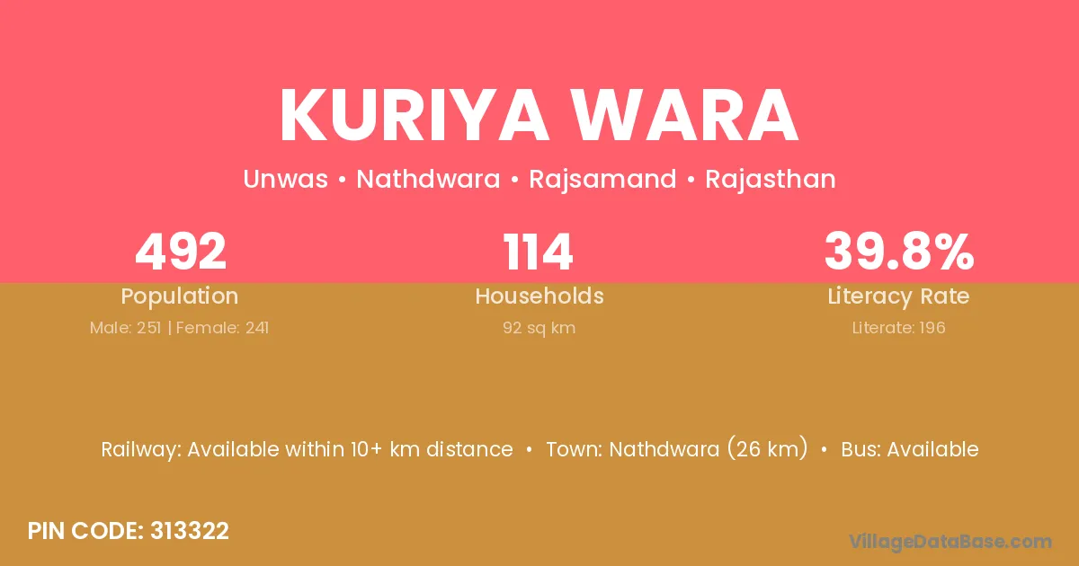
Kuriya Wara village is located in the Nathdwara Tehsil of the Rajsamand district in Rajasthan .
Block / Tehsil → Nathdwara
District → Rajsamand
State → Rajasthan
According to Census 2011 information, the village code of Kuriya Wara village is 313322.
Kuriya Wara village has a total population of 492 people, of which 251 are males and 241 are females.
The literacy rate of Kuriya Wara village is 39.84%. Male literacy stands at 54.98% and female literacy at 24.07%.
There are approximately 114 households in Kuriya Wara village.
Nathdwara (26 km) is the nearest town to Kuriya Wara village for major economic activities and is located approximately 26 km away.
The population of Kuriya Wara village is distributed between literate and illiterate residents as follows:
| Particulars | Male | Female | Total |
|---|---|---|---|
| Literate | 138 | 58 | 196 |
| Illiterate | 113 | 183 | 296 |
| Total | 251 | 241 | 492 |
Source: Census 2011
| Village | District |
|---|---|
| Balicha | Rajsamand |
| Kharwaron Ki Dhani | Rajsamand |
| Lal Madri | Rajsamand |
| Maal Ka Guda | Rajsamand |
| Pasuniya | Gandhinagar |
| Pasuniya | Rajsamand |
| Rabcha | Rajsamand |
| Ranawaton Ka Gura | Rajsamand |
| Ranawaton Ka Gura | Udaipur |
| Rebariyon Ki Dhani | Bhilwara |
| Rebariyon Ki Dhani | Chittaurgarh |
| Rebariyon Ki Dhani | Rajsamand |
| Rebariyon Ki Dhani | Udaipur |
| Rebariyon Ki Dhani | Udaipur |
| Roopji Ka Guda | Rajsamand |
| Unwas | Rajsamand |
| Warni Ki Bhagal | Rajsamand |
No reviews yet. Be the first to review this village!
Available within 10+ km distance
Available within 10+ km distance
Available within <5 km distance