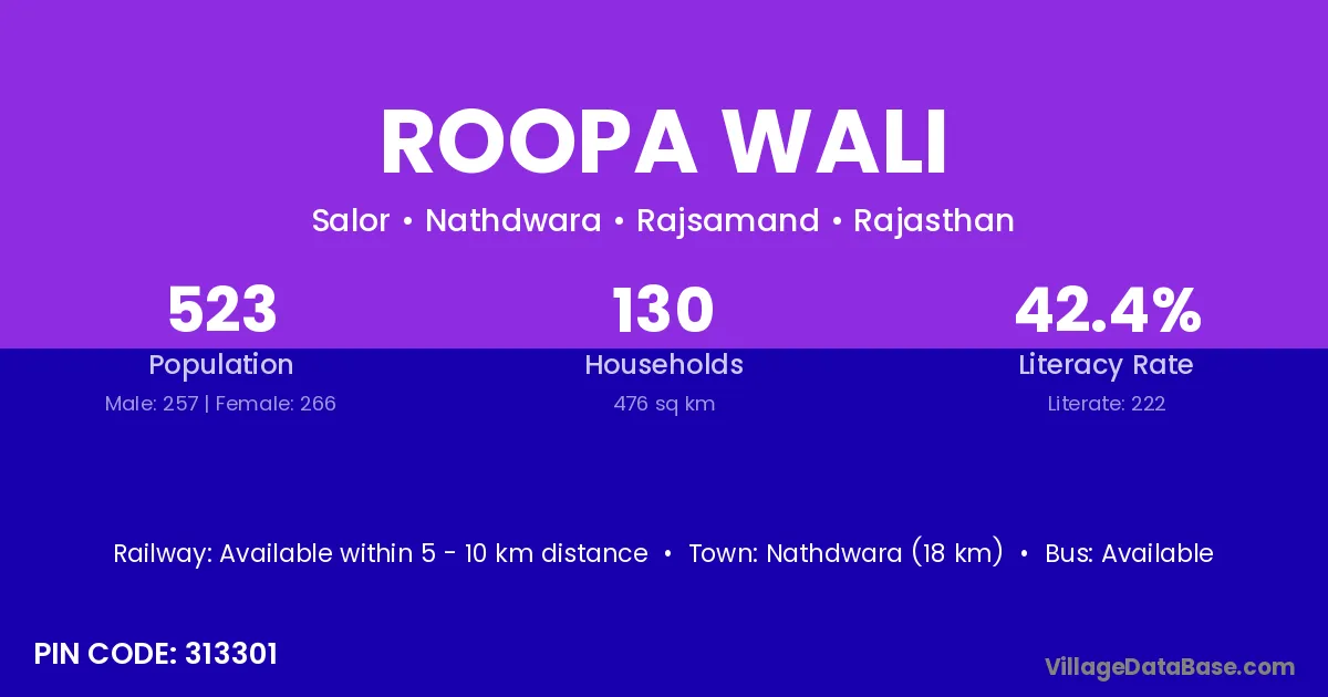
Roopa Wali village is located in the Nathdwara Tehsil of the Rajsamand district in Rajasthan .
Block / Tehsil → Nathdwara
District → Rajsamand
State → Rajasthan
According to Census 2011 information, the village code of Roopa Wali village is 313301.
Roopa Wali village has a total population of 523 people, of which 257 are males and 266 are females.
The literacy rate of Roopa Wali village is 42.45%. Male literacy stands at 55.64% and female literacy at 29.70%.
There are approximately 130 households in Roopa Wali village.
Nathdwara (18 km) is the nearest town to Roopa Wali village for major economic activities and is located approximately 18 km away.
The population of Roopa Wali village is distributed between literate and illiterate residents as follows:
| Particulars | Male | Female | Total |
|---|---|---|---|
| Literate | 143 | 79 | 222 |
| Illiterate | 114 | 187 | 301 |
| Total | 257 | 266 | 523 |
Source: Census 2011
| Village | District |
|---|---|
| Akodra | Sabar Kantha |
| Akodra | Rajsamand |
| Akodra | Udaipur |
| Baroliyon Ka Khera | Rajsamand |
| Depur | Anugul |
| Depur | Kalahandi |
| Depur | Kendrapara |
| Depur | Hoshiarpur |
| Depur | Nagaur |
| Depur | Pratapgarh |
| Depur | Rajsamand |
| Depur | Udaipur |
| Halawas | Rajsamand |
| Lachhipura | Sagar |
| Lachhipura | Rajsamand |
| Mallakheri | Rajsamand |
| Mandiyana | Rajsamand |
| Mogana | Rajsamand |
| Pakhand | Rajsamand |
| Saalor | Rajsamand |
| Takadiyon Ka Gurha | Rajsamand |
No reviews yet. Be the first to review this village!
Available within 5 - 10 km distance
Available within <5 km distance
Available within village