Railmagra: A Town and Tehsil in Rajsamand district
District → Rajsamand
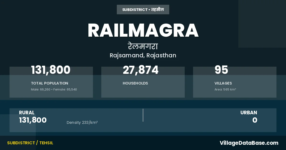
State → Rajasthan
Railmagra is a town and Tehsil in the Rajsamand district of the Rajasthan. In India, a Tehsil is a subdivision of a district responsible for the administration and revenue collection of a specific area within the district. Tehsils play a crucial role in the local governance structure, contributing significantly to the development and administration of their communities.
According to the 2011 census The total area of Railmagra Tehsil is 565 km², with a population of 131800 people. The population density is 233 inhabitants per square kilometre, and there are approximately 27874 houses in the sub district.
Railmagra Tehsil comprises about 95 villages. Below is a list of these villages along with information about their respective gram panchayats and the nearest town:
| # | Village Name | Gram Panchayat | Nearest Town |
|---|---|---|---|
| 1 | Amarpura | Khar Bamaniya | Kapasan (20 km) |
| 2 | Anjana | Gawaradi | Fatehnagar (16 km) |
| 3 | Ardakiya | Ora | Rajsamand (22 km) |
| 4 | Bagatpura | Khar Bamaniya | Kapasan (25 km) |
| 5 | Bakhatpura | Lapasiya Akhera | Rajsamand (25 km) |
| 6 | Bamniya Kalan | Bamniya Kalan | Rajsamand (37 km) |
| 7 | Banediya | Banediya | Fatehnagar (20 km) |
| 8 | Bethumbi | Panotiya | Gangapur (20 km) |
| 9 | Bhama Khera | Peepali Dodiyan | Rajsamand (30 km) |
| 10 | Bharai | Sadri | Rajsamand (25 km) |
| 11 | Bhoorwara | Chokri | Rajsamand (22 km) |
| 12 | Chak Joonda | Joonda | Rajsamand (33 km) |
| 13 | Chanpa Kheri | Pachhmata | Kapasan (27 km) |
| 14 | Charana | Charana | Fatehnagar (13 km) |
| 15 | Chawandiya | Dhaneriya | Fatehnagar (15 km) |
| 16 | Chhapri | Dhaneriya | Fatehnagar (14 km) |
| 17 | Chhdanga Khera | Sansera | Fatehnagar (10 km) |
| 18 | Chhdanga Kheri | Charana | Fatehnagar (20 km) |
| 19 | Chhtri Khera | Khar Bamaniya | Kapasan (23 km) |
| 20 | Chokri | Chokri | Rajsamand (24 km) |
| 21 | Damodarpura | Khar Bamaniya | Kapasan (20 km) |
| 22 | Dariba | Mehanduriya | Fatehnagar (12 km) |
| 23 | Dhaneriya | Dhaneriya | Fatehnagar (14 km) |
| 24 | Dheeli | Banediya | Fatehnagar (22 km) |
| 25 | Dolatpura | Lapasiya Akhera | Rajsamand (30 km) |
| 26 | Gamerpura | Sansera | Fatehnagar (25 km) |
| 27 | Ganeshpura | Joonda | Gangapur (20 km) |
| 28 | Gangas | Jawasya | Kapasan (20 km) |
| 29 | Gawaradi | Gawaradi | Fatehnagar (14 km) |
| 30 | Gilund | Gilund | Kapasan (16 km) |
| 31 | Gogathala | Gogathala | Rajsamand (30 km) |
| 32 | Jagatsingh Ji Ka Khera | Charana | Fatehnagar (7 km) |
| 33 | Jagpura | Panotiya | Gangapur (20 km) |
| 34 | Jawasiya | Jawasya | Kapasan (25 km) |
| 35 | Jeetawas | Jeetawas | Rajsamand (35 km) |
| 36 | Jeewa Khera | Jeetawas | Rajsamand (37 km) |
| 37 | Joonda | Joonda | Rajsamand (30 km) |
| 38 | Joonda Ki Kheri | Joonda | Rajsamand (32 km) |
| 39 | Kabra | Kabra | Kapasan (25 km) |
| 40 | Kanakhera | Kuraj | Rajsamand (38 km) |
| 41 | Karma Kheri | Panotiya | Gangapur (18 km) |
| 42 | Karoliya | Sadri | Rajsamand (30 km) |
| 43 | Katiya Khera | Mehanduriya | Fatehnagar (15 km) |
| 44 | Khandel | Lapasiya Akhera | Rajsamand (25 km) |
| 45 | Khar Bamaniya | Khar Bamaniya | Kapasan (25 km) |
| 46 | Khatookra | Charana | Fatehnagar (17 km) |
| 47 | Kishanpuriya | Joonda | Rajsamand (33 km) |
| 48 | Kolpura | Kundiya | Kapasan (20 km) |
| 49 | Kotrii | Kotrii | Fatehnagar (25 km) |
| 50 | Kundiya | Kundiya | Kapasan (25 km) |
| 51 | Kuraj | Kuraj | Rajsamand (35 km) |
| 52 | Ladpacha | Gawaradi | Fatehnagar (17 km) |
| 53 | Lakhmipura | Khar Bamaniya | Kapasan (23 km) |
| 54 | Lapsya Khera | Lapasiya Akhera | Rajsamand (27 km) |
| 55 | Lathiya Kheri | Sindesar Kalan | Rajsamand (32 km) |
| 56 | Laxmipura | Sadri | Rajsamand (26 km) |
| 57 | Madara | Sakarawas | Rajsamand (25 km) |
| 58 | Mahenduriya | Mehanduriya | Fatehnagar (20 km) |
| 59 | Makanpuriya | Kabra | Fatehnagar (20 km) |
| 60 | Mali Khera | Gogathala | Rajsamand (35 km) |
| 61 | Mandapiya Ka Khera | Kuraj | Rajsamand (37 km) |
| 62 | Mataji Ka Khera | Kotrii | Rajsamand (32 km) |
| 63 | Mau | Gogathala | Rajsamand (35 km) |
| 64 | Megha Khera | Peepali Aheeran | Rajsamand (23 km) |
| 65 | Meniya | Sadri | Rajsamand (30 km) |
| 66 | Mokhampura | Sakarawas | Rajsamand (21 km) |
| 67 | Morra | Sakarawas | Rajsamand (32 km) |
| 68 | Narayan Ganj | Ora | Rajsamand (20 km) |
| 69 | Ora | Ora | Rajsamand (20 km) |
| 70 | Pachhmata | Pachhmata | Kapasan (25 km) |
| 71 | Panotiya | Panotiya | Gangapur (25 km) |
| 72 | Peepali Aheeran | Peepali Aheeran | Rajsamand (20 km) |
| 73 | Peepali Dodiyan | Peepali Dodiyan | Rajsamand (25 km) |
| 74 | Peepawas | Kotrii | Fatehnagar (22 km) |
| 75 | Pema Khera | Gogathala | Rajsamand (28 km) |
| 76 | Phoonkiya | Peepali Dodiyan | Rajsamand (25 km) |
| 77 | Prempura | Peepali Aheeran | Rajsamand (23 km) |
| 78 | Railmagra | Railmagra | Rajsamand (28 km) |
| 79 | Rajpura | Rajpura | Fatehnagar (20 km) |
| 80 | Rampuriya | Lapasiya Akhera | Rajsamand (28 km) |
| 81 | Sadri | Sadri | Rajsamand (25 km) |
| 82 | Sakarawas | Sakarawas | Rajsamand (22 km) |
| 83 | Sansera | Sansera | Fatehnagar (24 km) |
| 84 | Sanwaliya Khera | Kabra | Kapasan (25 km) |
| 85 | Sanwalpura | Jawasya | Kapasan (23 km) |
| 86 | Sarwariya Kheri | Rajpura | Rajsamand (32 km) |
| 87 | Shivpura | Khar Bamaniya | Kapasan (25 km) |
| 88 | Shoupura | Mehanduriya | Fatehnagar (15 km) |
| 89 | Sindesar Kalan | Sindesar Kalan | Rajsamand (34 km) |
| 90 | Sindesarkhurd | Rajpura | Fatehnagar (25 km) |
| 91 | Soniyana | Pachhmata | Kapasan (23 km) |
| 92 | Sunariya Khera | Kabra | Fatehnagar (20 km) |
| 93 | Tara Khera | Lapasiya Akhera | Rajsamand (25 km) |
| 94 | Turkya Kheri | Banediya | Rajsamand (24 km) |
| 95 | Udalpura | Kotrii | Fatehnagar (28 km) |
The population is distributed between urban and rural areas as follows:
| Particulars | Rural | Urban | Total |
|---|---|---|---|
| Total Population | 131800 | 0 | 131800 |
| Male Population | 66260 | 0 | 66260 |
| Female Population | 65540 | 0 | 65540 | Population Density | 233 / km² | 233 / km² |
The distribution of households in the Railmagra is:
| Rural Households | Urban Households | Total Households |
|---|---|---|
| 27874 | 0 | 27874 |
Q: What is Railmagra?
A: Railmagra is a town and in the Rajsamand district of the Rajasthan.
Q: What is the total area of Railmagra Tehsil?
A: The total area of Railmagra Tehsil is 565 km².
Q: What is the population of Railmagra Tehsil according to the 2011 census?
A: According to the 2011 census, the population of Railmagra Tehsil is 131800.
Q: What is the population density of Railmagra Tehsil?
A: The population density of Railmagra Tehsil is 233 inhabitants per square kilometre.
Q: How many houses are there in Railmagra Tehsil?
A: There are approximately 27874 houses in Railmagra Tehsil.
Q: How many villages are there in Railmagra Tehsil?
A: There are about 95 villages in Railmagra Tehsil.
Q: Which is the largest village by population in Railmagra Tehsil?
A: The largest village by population in Railmagra Tehsil is Railmagra, with 8611 people.
Q: Which is the smallest village by population in Railmagra Tehsil?
A: The smallest village by population in Railmagra Tehsil is Chak Joonda, with 0 people.
Q: Which is the largest village by area in Railmagra Tehsil?
A: The largest village by area in Railmagra Tehsil is Kuraj, with 2778 km².
Q: Which is the smallest village by area in Railmagra Tehsil?
A: The smallest village by area in Railmagra Tehsil is Chak Joonda, with 17 km².
Q: What is the population distribution between urban and rural areas in Railmagra Tehsil?
A: The population distribution in Railmagra Tehsil is entirely rural, with a total rural population of 131800.
Q: What is the male population of Railmagra Tehsil?
A: The male population of Railmagra Tehsil is 66260.
Q: What is the female population of Railmagra Tehsil?
A: The female population of Railmagra Tehsil is 65540.
Q: How is the household distribution in Railmagra Tehsil?
A: The household distribution in Railmagra Tehsil is entirely rural, with a total of 27874 households.
Q: How many villages in Railmagra Tehsil have a population of less than 100?
A: There are 4 villages in Railmagra Tehsil with a population of less than 100.
Q: How many villages in Railmagra Tehsil have a population between 100 and 499?
A: There are 19 villages in Railmagra Tehsil with a population between 100 and 499.
Q: How many villages in Railmagra Tehsil have a population between 500 and 999?
A: There are 26 villages in Railmagra Tehsil with a population between 500 and 999.
Q: How many villages in Railmagra Tehsil have a population between 1000 and 1999?
A: There are 25 villages in Railmagra Tehsil with a population between 1000 and 1999.
Q: How many villages in Railmagra Tehsil have a population between 2000 and 2999?
A: There is 14 village in Railmagra Tehsil with a population between 2000 and 2999.
Q: How many villages in Railmagra Tehsil have a population between 3000 and 3999?
A: There is 4 village in Railmagra Tehsil with a population between 3000 and 3999.
Q: How many villages in Railmagra Tehsil have a population of 5000 and above?
A: There is 3 village in Railmagra Tehsil with a population of 5000 and above.
| Total Population | Villages in Sub District Of Railmagra |
|---|---|
| Less than 100 | 4 |
| 100-499 | 19 |
| 500-999 | 26 |
| 1000-1999 | 25 |
| 2000-2999 | 14 |
| 3000-3999 | 4 |
| 5000 And Above | 3 |