Rongli: A Town and Subdivision in East District district
District → East District
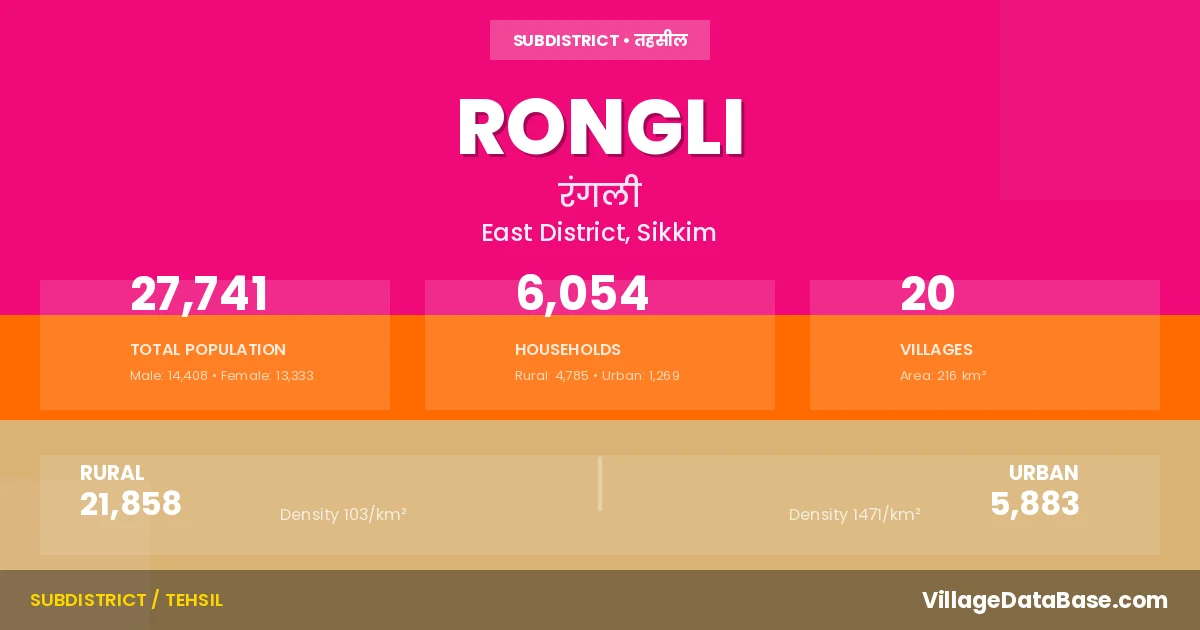
State → Sikkim
Rongli is a town and Subdivision in the East District district of the Sikkim. In India, a Subdivision is a subdivision of a district responsible for the administration and revenue collection of a specific area within the district. Subdivisions play a crucial role in the local governance structure, contributing significantly to the development and administration of their communities.
According to the 2011 census The total area of Rongli Subdivision is 216 km², with a population of 27741 people. The population density is 128 inhabitants per square kilometre, and there are approximately 6054 houses in the sub district.
Rongli Subdivision comprises about 20 villages. Below is a list of these villages along with information about their respective gram panchayats and the nearest town:
| # | Village Name | Gram Panchayat | Nearest Town |
|---|---|---|---|
| 1 | Aritar | Aritar | Rangpo (29 km) |
| 2 | Changeylakha | Rongli Chengeylakha | Rangpo (37 km) |
| 3 | Chujachen | Chujachen | Rangpo (38 km) |
| 4 | Dholepchen | Dolepchen | Rangpo (31 km) |
| 5 | Lamaten | Rolep Lamaten | Rangpo (51 km) |
| 6 | Lingtam | Lingtam Phadamchen | Rangpo (43 km) |
| 7 | Mulukey | Sudunglakha | Rangpo (26 km) |
| 8 | North Rhegoh | Regoh | Rangpo (44 km) |
| 9 | Phadamchen | Lingtam Phadamchen | Rangpo (55 km) |
| 10 | Phadamchen Forest Block | Lingtam Phadamchen | Rangpo (64 km) |
| 11 | Premlakha | Premlakha Subaneydara | Rangpo (67 km) |
| 12 | Rhenak | Rhenock | Rongli |
| 13 | Rhenock Forest Block | Rhenock | Rangpo (40 km) |
| 14 | Rolep | Rolep Lamaten | Rangpo (55 km) |
| 15 | Rongli Forest Block | Rongli Chengeylakha | Rangpo (56 km) |
| 16 | Singaneybas | Premlakha Subaneydara | Rangpo (60 km) |
| 17 | South Rhegoh | Regoh | Rangpo (43 km) |
| 18 | Subanedara | Premlakha Subaneydara | Rangpo (42 km) |
| 19 | Sudunglakha | Sudunglakha | Rangpo (28 km) |
| 20 | Tarpin | Tarpin | Rangpo (17 km) |
The population is distributed between urban and rural areas as follows:
| Particulars | Rural | Urban | Total |
|---|---|---|---|
| Total Population | 21858 | 5883 | 27741 |
| Male Population | 11234 | 3174 | 14408 |
| Female Population | 10624 | 2709 | 13333 | Population Density | 103 / km² | 1471 / km² | 128 / km² |
The distribution of households in the Rongli is:
| Rural Households | Urban Households | Total Households |
|---|---|---|
| 4785 | 1269 | 6054 |
Q: What is Rongli?
A: Rongli is a town and in the East District district of the Sikkim.
Q: What is the total area of Rongli Subdivision?
A: The total area of Rongli Subdivision is 216 km².
Q: What is the population of Rongli Subdivision according to the 2011 census?
A: According to the 2011 census, the population of Rongli Subdivision is 27741.
Q: What is the population density of Rongli Subdivision?
A: The population density of Rongli Subdivision is 128 inhabitants per square kilometre.
Q: How many houses are there in Rongli Subdivision?
A: There are approximately 6054 houses in Rongli Subdivision.
Q: How many villages are there in Rongli Subdivision?
A: There are about 20 villages in Rongli Subdivision.
Q: Which is the largest village by population in Rongli Subdivision?
A: The largest village by population in Rongli Subdivision is Chujachen, with 4781 people.
Q: Which is the smallest village by population in Rongli Subdivision?
A: The smallest village by population in Rongli Subdivision is Phadamchen Forest Block, with 0 people.
Q: Which is the largest village by area in Rongli Subdivision?
A: The largest village by area in Rongli Subdivision is Rongli Forest Block, with 9259 km².
Q: Which is the smallest village by area in Rongli Subdivision?
A: The smallest village by area in Rongli Subdivision is Phadamchen Forest Block, with 0 km².
Q: What is the male population of Rongli Subdivision?
A: The male population of Rongli Subdivision is 14408.
Q: What is the female population of Rongli Subdivision?
A: The female population of Rongli Subdivision is 13333.
Q: How many villages in Rongli Subdivision have a population of less than 100?
A: There are 6 villages in Rongli Subdivision with a population of less than 100.
Q: How many villages in Rongli Subdivision have a population between 100 and 499?
A: There are 1 villages in Rongli Subdivision with a population between 100 and 499.
Q: How many villages in Rongli Subdivision have a population between 500 and 999?
A: There are 6 villages in Rongli Subdivision with a population between 500 and 999.
Q: How many villages in Rongli Subdivision have a population between 1000 and 1999?
A: There are 4 villages in Rongli Subdivision with a population between 1000 and 1999.
Q: How many villages in Rongli Subdivision have a population between 2000 and 2999?
A: There is 1 village in Rongli Subdivision with a population between 2000 and 2999.
Q: How many villages in Rongli Subdivision have a population between 3000 and 3999?
A: There is 1 village in Rongli Subdivision with a population between 3000 and 3999.
Q: How many villages in Rongli Subdivision have a population between 4000 and 4999?
A: There is 1 village in Rongli Subdivision with a population between 4000 and 4999.
| Total Population | Villages in Sub District Of Rongli |
|---|---|
| Less than 100 | 6 |
| 100-499 | 1 |
| 500-999 | 6 |
| 1000-1999 | 4 |
| 2000-2999 | 1 |
| 3000-3999 | 1 |
| 4000-4999 | 1 |