Munpalle: A Town and Mandal in Medak district
District → Medak
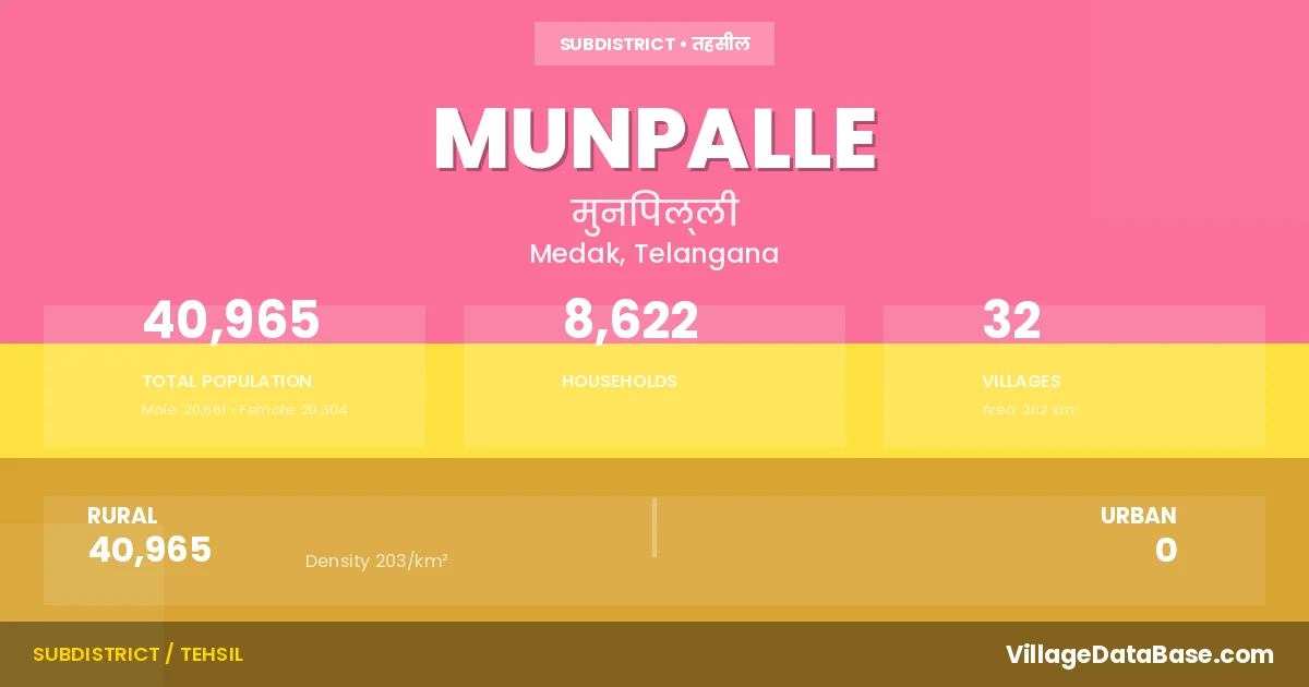
State → Telangana
Munpalle is a town and Mandal in the Medak district of the Telangana. In India, a Mandal is a subdivision of a district responsible for the administration and revenue collection of a specific area within the district. Mandals play a crucial role in the local governance structure, contributing significantly to the development and administration of their communities.
According to the 2011 census The total area of Munpalle Mandal is 202 km², with a population of 40965 people. The population density is 203 inhabitants per square kilometre, and there are approximately 8622 houses in the sub district.
Munpalle Mandal comprises about 32 villages. Below is a list of these villages along with information about their respective gram panchayats and the nearest town:
| # | Village Name | Gram Panchayat | Nearest Town |
|---|---|---|---|
| 1 | Allapuram | Mallikarjunpally | Sadasivpet (22 km) |
| 2 | Antharam | Antharam | Sadasivpet (22 km) |
| 3 | Belur | Belur | Sadasivpet (48 km) |
| 4 | Bhusareddipalle | Bhusareddipalle | Sadasivpet (26 km) |
| 5 | Bodishetpalle | Bodishetpalle | Sadasivpet (19 km) |
| 6 | Bodpalle | Bodpalle | Sadasivpet (30 km) |
| 7 | Budhera | Budhera | Sadasivpet (15 km) |
| 8 | Chilepalle | Chilepalle | Sadasivpet (38 km) |
| 9 | Chinna Loni | Chinna Loni | Sadasivpet (31 km) |
| 10 | Chinnachelmeda | Chinnachelmeda | Sadasivpet (26 km) |
| 11 | Garlapalle | Garlapalle | Sadasivpet (38 km) |
| 12 | Gorreghat | Kamkole | Sadasivpet (16 km) |
| 13 | Hydlapoor | Mallikarjunpally | Sadasivpet (25 km) |
| 14 | Ibrahimpur | Budhera | Sadasivpet (13 km) |
| 15 | Kallapalle | Belur | Sadasivpet (48 km) |
| 16 | Kankole | Kamkole | Sadasivpet (15 km) |
| 17 | Khammampalle | Khammampalle | Sadasivpet (21 km) |
| 18 | Lingampalle | Lingampalle | Sadasivpet (17 km) |
| 19 | Makthakesaram | Makthakesaram | Sadasivpet (38 km) |
| 20 | Mallikarjunpalle | Mallikarjunpally | Sadasivpet (25 km) |
| 21 | Mansanpalle | Mansanpalle | Sadasivpet (26 km) |
| 22 | Melasangam | Melasangam | Sadasivpet (20 km) |
| 23 | Moqdumpalle | Moqdumpalle | Sadasivpet (17 km) |
| 24 | Munpalle | Munpalle | Sadasivpet (20 km) |
| 25 | Pedda Chelmeda | Pedda Chelmeda | Sadasivpet (23 km) |
| 26 | Pedda Gopalaram | Pedda Gopalaram | Sadasivpet (15 km) |
| 27 | Pedda Loni | Pedda Loni | Sadasivpet (38 km) |
| 28 | Polkampalle | Polkampalle | Sadasivpet (14 km) |
| 29 | Ramachandrapuram | Sadasivpet (50 km) | |
| 30 | Rekulpahad | Sadasivpet (44 km) | |
| 31 | Tatipalle | Tatipalle | Sadasivpet (27 km) |
| 32 | Thakkadpalle | Thakkadpalle | Sadasivpet (26 km) |
The population is distributed between urban and rural areas as follows:
| Particulars | Rural | Urban | Total |
|---|---|---|---|
| Total Population | 40965 | 0 | 40965 |
| Male Population | 20661 | 0 | 20661 |
| Female Population | 20304 | 0 | 20304 | Population Density | 203 / km² | 203 / km² |
The distribution of households in the Munpalle is:
| Rural Households | Urban Households | Total Households |
|---|---|---|
| 8622 | 0 | 8622 |
Q: What is Munpalle?
A: Munpalle is a town and in the Medak district of the Telangana.
Q: What is the total area of Munpalle Mandal?
A: The total area of Munpalle Mandal is 202 km².
Q: What is the population of Munpalle Mandal according to the 2011 census?
A: According to the 2011 census, the population of Munpalle Mandal is 40965.
Q: What is the population density of Munpalle Mandal?
A: The population density of Munpalle Mandal is 203 inhabitants per square kilometre.
Q: How many houses are there in Munpalle Mandal?
A: There are approximately 8622 houses in Munpalle Mandal.
Q: How many villages are there in Munpalle Mandal?
A: There are about 32 villages in Munpalle Mandal.
Q: Which is the largest village by population in Munpalle Mandal?
A: The largest village by population in Munpalle Mandal is Munpalle, with 3393 people.
Q: Which is the smallest village by population in Munpalle Mandal?
A: The smallest village by population in Munpalle Mandal is Ramachandrapuram, with 0 people.
Q: Which is the largest village by area in Munpalle Mandal?
A: The largest village by area in Munpalle Mandal is Munpalle, with 1662 km².
Q: Which is the smallest village by area in Munpalle Mandal?
A: The smallest village by area in Munpalle Mandal is Moqdumpalle, with 140 km².
Q: What is the population distribution between urban and rural areas in Munpalle Mandal?
A: The population distribution in Munpalle Mandal is entirely rural, with a total rural population of 40965.
Q: What is the male population of Munpalle Mandal?
A: The male population of Munpalle Mandal is 20661.
Q: What is the female population of Munpalle Mandal?
A: The female population of Munpalle Mandal is 20304.
Q: How is the household distribution in Munpalle Mandal?
A: The household distribution in Munpalle Mandal is entirely rural, with a total of 8622 households.
Q: How many villages in Munpalle Mandal have a population of less than 100?
A: There are 2 villages in Munpalle Mandal with a population of less than 100.
Q: How many villages in Munpalle Mandal have a population between 100 and 499?
A: There are 2 villages in Munpalle Mandal with a population between 100 and 499.
Q: How many villages in Munpalle Mandal have a population between 500 and 999?
A: There are 11 villages in Munpalle Mandal with a population between 500 and 999.
Q: How many villages in Munpalle Mandal have a population between 1000 and 1999?
A: There are 11 villages in Munpalle Mandal with a population between 1000 and 1999.
Q: How many villages in Munpalle Mandal have a population between 2000 and 2999?
A: There is 5 village in Munpalle Mandal with a population between 2000 and 2999.
Q: How many villages in Munpalle Mandal have a population between 3000 and 3999?
A: There is 1 village in Munpalle Mandal with a population between 3000 and 3999.
| Total Population | Villages in Sub District Of Munpalle |
|---|---|
| Less than 100 | 2 |
| 100-499 | 2 |
| 500-999 | 11 |
| 1000-1999 | 11 |
| 2000-2999 | 5 |
| 3000-3999 | 1 |