District → Warangal
State → Telangana
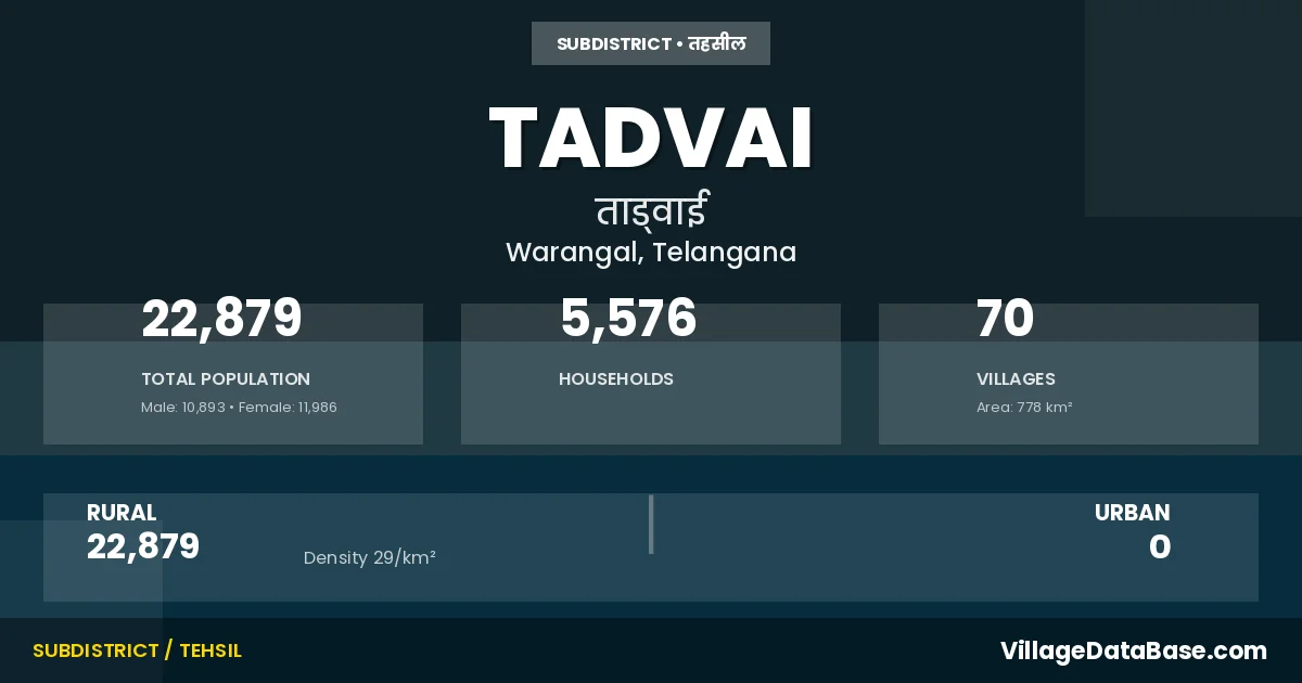
Tadvai is a town and Mandal in the Warangal district of the Telangana. In India, a Mandal is a subdivision of a district responsible for the administration and revenue collection of a specific area within the district. Mandals play a crucial role in the local governance structure, contributing significantly to the development and administration of their communities.
According to the 2011 census The total area of Tadvai Mandal is 778 km², with a population of 22879 people. The population density is 29 inhabitants per square kilometre, and there are approximately 5576 houses in the sub district.
Tadvai Mandal comprises about 70 villages. Below is a list of these villages along with information about their respective gram panchayats and the nearest town:
| # | Village Name | Gram Panchayat | Nearest Town |
|---|---|---|---|
| 1 | Adhervai | Kalwapalli | Warangal (110 km) |
| 2 | Alligudem | Lingala | Warangal (102 km) |
| 3 | Ankampalle | Pambapur | Warangal (110 km) |
| 4 | Annaram | Gangaram | Warangal (90 km) |
| 5 | Ashannagudem Yellapur | Beerelli | Warangal (113 km) |
| 6 | Banjarellapur | Gangaram | Warangal (90 km) |
| 7 | Bayyakkapet | Bayyakkapet | Warangal (98 km) |
| 8 | Beerelli | Beerelli | Warangal (115 km) |
| 9 | Bhupatipuram | Gangaram | Warangal (90 km) |
| 10 | Bittupalle | Lingala | Warangal (89 km) |
| 11 | Bodigudem | Tadvai | Warangal (93 km) |
| 12 | Bollepalle | Lingala | Warangal (99 km) |
| 13 | Bondal | Lingala | Warangal (98 km) |
| 14 | Budigavanipahad | Narlapur | Warangal (91 km) |
| 15 | Chennapuram | Tadvai | Warangal (95 km) |
| 16 | Chintalakatapur | Lingala | Warangal (98 km) |
| 17 | Chowled | Narlapur | Warangal (122 km) |
| 18 | Damervai | Dameravai | Warangal (118 km) |
| 19 | Durgaram | Kalwapalli | Warangal (113 km) |
| 20 | Elbaka | Narlapur | Warangal (89 km) |
| 21 | Gangaram | Gangaram | Warangal (90 km) |
| 22 | Gonepalle | Narlapur | Warangal (87 km) |
| 23 | Gopaigudem | Gangaram | Warangal (90 km) |
| 24 | Gouraram | Narsapur P A | Warangal (90 km) |
| 25 | Immadigudem | Gangaram | Warangal (90 km) |
| 26 | Jampangavai | Oorattam | Warangal (96 km) |
| 27 | Kalwapalle | Kalwapalli | Warangal (95 km) |
| 28 | Kamaram | Tadvai | Warangal (93 km) |
| 29 | Kamsettigudem | Beerelli | Warangal (118 km) |
| 30 | Kanneboinapalle | Oorattam | Warangal (101 km) |
| 31 | Katapuram | Katapuram | Warangal (114 km) |
| 32 | Katnarsapuram | Narsapur P A | Warangal (105 km) |
| 33 | Keshavapoor | Narsapur P A | Warangal (111 km) |
| 34 | Kistapuram | Gangaram | Warangal (90 km) |
| 35 | Kondaiguda | Lingala | Warangal (101 km) |
| 36 | Kondalanagaram | Gangaram | Warangal (90 km) |
| 37 | Kondaparthi | Tadvai | Warangal (88 km) |
| 38 | Kothagudem | Lingala | Warangal (98 km) |
| 39 | Kothur | Kalwapalli | Warangal (96 km) |
| 40 | Kousettivai | Pambapur | Warangal (110 km) |
| 41 | Lavval | Lingala | Warangal (87 km) |
| 42 | Laxmipuram | Gangaram | Warangal (90 km) |
| 43 | Lingala | Lingala | Warangal (102 km) |
| 44 | Madaram | Kalwapalli | Warangal (114 km) |
| 45 | Maredigudem | Tadvai | Warangal (93 km) |
| 46 | Medaram | Oorattam | Warangal (104 km) |
| 47 | Motlagudem | Lingala | Warangal (98 km) |
| 48 | Narlapur | Narlapur | Warangal (88 km) |
| 49 | Narsapur | Narsapur P A | Warangal (105 km) |
| 50 | Nimmagudem | Beerelli | Warangal (116 km) |
| 51 | Nimmakayala Nagaram | Narlapur | Warangal (99 km) |
| 52 | Oorattam | Oorattam | Warangal (101 km) |
| 53 | Padigapuram | Narlapur | Warangal (89 km) |
| 54 | Pambapuram | Pambapur | Warangal (107 km) |
| 55 | Pocha Palle | Lingala | Warangal (94 km) |
| 56 | Ramannagudem | Gangaram | Warangal (90 km) |
| 57 | Rampur | Pambapur | Warangal (112 km) |
| 58 | Rangapuram | Beerelli | Warangal (118 km) |
| 59 | Sattaram | Beerelli | Warangal (110 km) |
| 60 | Serigaram | Dameravai | Warangal (116 km) |
| 61 | Somaigudem | Gangaram | Warangal (90 km) |
| 62 | Tadvai | Tadvai | Warangal (91 km) |
| 63 | Thakkallagudem | Narlapur | Warangal (90 km) |
| 64 | Timmanitogu | Lingala | Warangal (100 km) |
| 65 | Uppukunta | Katapuram | Warangal (92 km) |
| 66 | Vaddagudem | Lingala | Warangal (102 km) |
| 67 | Veerapuram | Beerelli | Warangal (116 km) |
| 68 | Vengalapuram | Narlapur | Warangal (85 km) |
| 69 | Venkannagudem | Beerelli | Warangal (114 km) |
| 70 | Waddegudem | Lingala | Warangal (85 km) |
The population is distributed between urban and rural areas as follows:
| Particulars | Rural | Urban | Total |
|---|---|---|---|
| Total Population | 22879 | 0 | 22879 |
| Male Population | 10893 | 0 | 10893 |
| Female Population | 11986 | 0 | 11986 | Population Density | 29 / km² | 29 / km² |
The distribution of households in the Tadvai is:
| Rural Households | Urban Households | Total Households |
|---|---|---|
| 5576 | 0 | 5576 |
Q: What is Tadvai?
A: Tadvai is a town and in the Warangal district of the Telangana.
Q: What is the total area of Tadvai Mandal?
A: The total area of Tadvai Mandal is 778 km².
Q: What is the population of Tadvai Mandal according to the 2011 census?
A: According to the 2011 census, the population of Tadvai Mandal is 22879.
Q: What is the population density of Tadvai Mandal?
A: The population density of Tadvai Mandal is 29 inhabitants per square kilometre.
Q: How many houses are there in Tadvai Mandal?
A: There are approximately 5576 houses in Tadvai Mandal.
Q: How many villages are there in Tadvai Mandal?
A: There are about 70 villages in Tadvai Mandal.
Q: Which is the largest village by population in Tadvai Mandal?
A: The largest village by population in Tadvai Mandal is Katapuram, with 2608 people.
Q: Which is the smallest village by population in Tadvai Mandal?
A: The smallest village by population in Tadvai Mandal is Adhervai, with 0 people.
Q: Which is the largest village by area in Tadvai Mandal?
A: The largest village by area in Tadvai Mandal is Bondal, with 2729 km².
Q: Which is the smallest village by area in Tadvai Mandal?
A: The smallest village by area in Tadvai Mandal is Chennapuram, with 0 km².
Q: What is the population distribution between urban and rural areas in Tadvai Mandal?
A: The population distribution in Tadvai Mandal is entirely rural, with a total rural population of 22879.
Q: What is the male population of Tadvai Mandal?
A: The male population of Tadvai Mandal is 10893.
Q: What is the female population of Tadvai Mandal?
A: The female population of Tadvai Mandal is 11986.
Q: How is the household distribution in Tadvai Mandal?
A: The household distribution in Tadvai Mandal is entirely rural, with a total of 5576 households.
Q: How many villages in Tadvai Mandal have a population of less than 100?
A: There are 36 villages in Tadvai Mandal with a population of less than 100.
Q: How many villages in Tadvai Mandal have a population between 100 and 499?
A: There are 20 villages in Tadvai Mandal with a population between 100 and 499.
Q: How many villages in Tadvai Mandal have a population between 500 and 999?
A: There are 8 villages in Tadvai Mandal with a population between 500 and 999.
Q: How many villages in Tadvai Mandal have a population between 1000 and 1999?
A: There are 4 villages in Tadvai Mandal with a population between 1000 and 1999.
Q: How many villages in Tadvai Mandal have a population between 2000 and 2999?
A: There is 2 village in Tadvai Mandal with a population between 2000 and 2999.
| Total Population | Villages in Sub District Of Tadvai |
|---|---|
| Less than 100 | 36 |
| 100-499 | 20 |
| 500-999 | 8 |
| 1000-1999 | 4 |
| 2000-2999 | 2 |