District → Dehradun
State → Uttarakhand
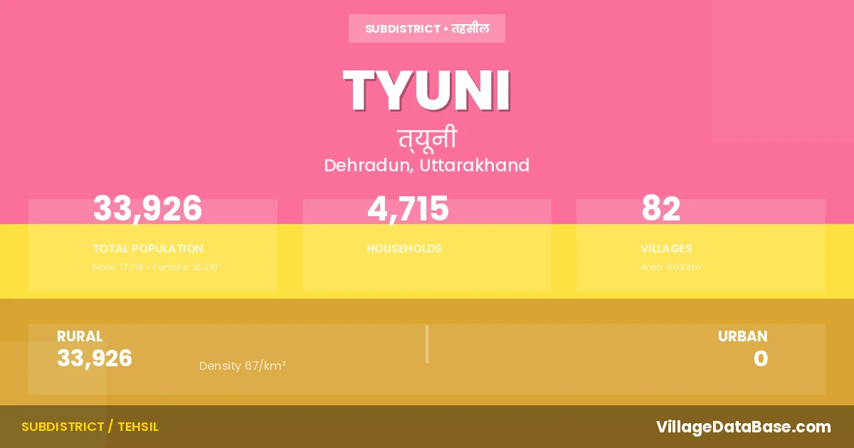
Tyuni is a town and Tehsil in the Dehradun district of the Uttarakhand. In India, a Tehsil is a subdivision of a district responsible for the administration and revenue collection of a specific area within the district. Tehsils play a crucial role in the local governance structure, contributing significantly to the development and administration of their communities.
According to the 2011 census The total area of Tyuni Tehsil is 503 km², with a population of 33926 people. The population density is 67 inhabitants per square kilometre, and there are approximately 4715 houses in the sub district.
Tyuni Tehsil comprises about 82 villages. Below is a list of these villages along with information about their respective gram panchayats and the nearest town:
| # | Village Name | Gram Panchayat | Nearest Town |
|---|---|---|---|
| 1 | Amarad Jhabrad | Amrad Jhabrad | Chakrata (44 km) |
| 2 | Anu | Annu | Chakrata (14 km) |
| 3 | Asoi | Asoi | Chakrata (48 km) |
| 4 | Babar Range | Chakrata (53 km) | |
| 5 | Bagani | Begi | Chakrata (37 km) |
| 6 | Bagi | Begi | Chakrata (5 km) |
| 7 | Bagoor | Bhagur | Chakrata (35 km) |
| 8 | Baigi | Maindrath | Chakrata (38 km) |
| 9 | Banachilar | Chilhaad | Chakrata (20 km) |
| 10 | Banpur | Chakrata (18 km) | |
| 11 | Bayala | Bayala | Chakrata (42 km) |
| 12 | Bhagawat | Meghatu | Chakrata (10 km) |
| 13 | Bhandroli | Bhandroli | Chakrata (45 km) |
| 14 | Bhatgarhi | Bhatgarhi | Chakrata (10 km) |
| 15 | Bhattar | Bhataad | Chakrata (40 km) |
| 16 | Bhoot | Bhute | Chakrata (43 km) |
| 17 | Bhunar | Bhunar | Chakrata (35 km) |
| 18 | Brinad Bastil | Brinad Basthil | Chakrata (5 km) |
| 19 | Bulad | Bulad | Chakrata (38 km) |
| 20 | Buraila | Burayala | Chakrata (30 km) |
| 21 | Chanjoi | Chanjoi | Chakrata (49 km) |
| 22 | Chatra | Chatra | Chakrata (15 km) |
| 23 | Chausal | Sakdeena | Chakrata (8 km) |
| 24 | Chhajar Hartad | Hartad Chajad | Chakrata (43 km) |
| 25 | Chhumara | Meghatu | Chakrata (14 km) |
| 26 | Darmigar | Ninus | Chakrata (11 km) |
| 27 | Derasa | Pyunal | Chakrata (10 km) |
| 28 | Devdhar Range | Chakrata (20 km) | |
| 29 | Dimich | Bhandroli | Chakrata (47 km) |
| 30 | Dirnad | Dirnad | Chakrata (33 km) |
| 31 | Dungri | Dungri | Chakrata (41 km) |
| 32 | Eithan | Bhunar | Chakrata (30 km) |
| 33 | Gorchha | Kunwa | Chakrata (50 km) |
| 34 | Hanol | Chatra | Chakrata (13 km) |
| 35 | Hartal | Attal | Chakrata (8 km) |
| 36 | Hartar Santar | Hartad Santad | Chakrata (36 km) |
| 37 | Jagthan | Burayala | Chakrata (32 km) |
| 38 | Jhitand | Jhitaad | Chakrata (14 km) |
| 39 | Kaba Khera | Kawa Khada | Chakrata (54 km) |
| 40 | Kanaser Range | Chakrata (58 km) | |
| 41 | Kanda | Kanda | Chakrata (11 km) |
| 42 | Kandoi | Kandoi Bharam | Chakrata (58 km) |
| 43 | Karardie | Kairaad | Chakrata (28 km) |
| 44 | Kharaura | Kharaura | Chakrata (43 km) |
| 45 | Kholara | Amrad Jhabrad | Chakrata (37 km) |
| 46 | Kistur | Kisture | Chakrata (30 km) |
| 47 | Koti | Koti Babar | Chakrata (13 km) |
| 48 | Kulaha | Kulah | Chakrata (10 km) |
| 49 | Kuna | Kuna | Chakrata (5 km) |
| 50 | Kunaun | Kunaun | Chakrata (46 km) |
| 51 | Kunwa | Kunwa | Chakrata (49 km) |
| 52 | Maindrath | Maindrath | Chakrata (5 km) |
| 53 | Malta Range | Chakrata (18 km) | |
| 54 | Mangtar | Tuna | Chakrata (30 km) |
| 55 | Masak | Masak | Chakrata (33 km) |
| 56 | Meghatu | Meghatu | Chakrata (14 km) |
| 57 | Mundhola | Mundhol | Chakrata (10 km) |
| 58 | Nimaga | Kairaad | Chakrata (22 km) |
| 59 | Ninus | Chakrata (9 km) | |
| 60 | Obraser | Bhagur | Chakrata (35 km) |
| 61 | Paturi | Patud | Chakrata (30 km) |
| 62 | Penuwa | Penwa | Chakrata (40 km) |
| 63 | Phanar | Phanar | Chakrata (10 km) |
| 64 | Pheirij | Attal | Chakrata (8 km) |
| 65 | Pinguwa | Pinguwa | Chakrata (51 km) |
| 66 | Pivnal | Chakrata (14 km) | |
| 67 | Punig | Thartha | Chakrata (55 km) |
| 68 | Purtad | Purtad | Chakrata (17 km) |
| 69 | Radu | Radu | Chakrata (10 km) |
| 70 | Raigi | Raigi | Chakrata (3 km) |
| 71 | Raitad | Amrad Jhabrad | Chakrata (37 km) |
| 72 | Rajanu | Rajanu | Chakrata (41 km) |
| 73 | Sainj | Chakrata (16 km) | |
| 74 | Sarni | Saarni | Chakrata (35 km) |
| 75 | Seriya | Raigi | Chakrata (6 km) |
| 76 | Silaura | Chilhaad | Chakrata (46 km) |
| 77 | Sunir | Sunir | Chakrata (19 km) |
| 78 | Sunoi | Penwa | Chakrata (41 km) |
| 79 | Thartha | Thartha | Chakrata (52 km) |
| 80 | Tiutad | Tuetaad | Chakrata (7 km) |
| 81 | Tuna | Tuna | Chakrata (30 km) |
| 82 | Undawa | Bulad | Chakrata (31 km) |
The population is distributed between urban and rural areas as follows:
| Particulars | Rural | Urban | Total |
|---|---|---|---|
| Total Population | 33926 | 0 | 33926 |
| Male Population | 17716 | 0 | 17716 |
| Female Population | 16210 | 0 | 16210 | Population Density | 67 / km² | 67 / km² |
The distribution of households in the Tyuni is:
| Rural Households | Urban Households | Total Households |
|---|---|---|
| 4715 | 0 | 4715 |
Q: What is Tyuni?
A: Tyuni is a town and in the Dehradun district of the Uttarakhand.
Q: What is the total area of Tyuni Tehsil?
A: The total area of Tyuni Tehsil is 503 km².
Q: What is the population of Tyuni Tehsil according to the 2011 census?
A: According to the 2011 census, the population of Tyuni Tehsil is 33926.
Q: What is the population density of Tyuni Tehsil?
A: The population density of Tyuni Tehsil is 67 inhabitants per square kilometre.
Q: How many houses are there in Tyuni Tehsil?
A: There are approximately 4715 houses in Tyuni Tehsil.
Q: How many villages are there in Tyuni Tehsil?
A: There are about 82 villages in Tyuni Tehsil.
Q: Which is the largest village by population in Tyuni Tehsil?
A: The largest village by population in Tyuni Tehsil is Brinad Bastil, with 1990 people.
Q: Which is the smallest village by population in Tyuni Tehsil?
A: The smallest village by population in Tyuni Tehsil is Devdhar Range, with 0 people.
Q: Which is the largest village by area in Tyuni Tehsil?
A: The largest village by area in Tyuni Tehsil is Kanaser Range, with 6643 km².
Q: Which is the smallest village by area in Tyuni Tehsil?
A: The smallest village by area in Tyuni Tehsil is Devdhar Range, with 18 km².
Q: What is the population distribution between urban and rural areas in Tyuni Tehsil?
A: The population distribution in Tyuni Tehsil is entirely rural, with a total rural population of 33926.
Q: What is the male population of Tyuni Tehsil?
A: The male population of Tyuni Tehsil is 17716.
Q: What is the female population of Tyuni Tehsil?
A: The female population of Tyuni Tehsil is 16210.
Q: How is the household distribution in Tyuni Tehsil?
A: The household distribution in Tyuni Tehsil is entirely rural, with a total of 4715 households.
Q: How many villages in Tyuni Tehsil have a population of less than 100?
A: There are 8 villages in Tyuni Tehsil with a population of less than 100.
Q: How many villages in Tyuni Tehsil have a population between 100 and 499?
A: There are 55 villages in Tyuni Tehsil with a population between 100 and 499.
Q: How many villages in Tyuni Tehsil have a population between 500 and 999?
A: There are 15 villages in Tyuni Tehsil with a population between 500 and 999.
Q: How many villages in Tyuni Tehsil have a population between 1000 and 1999?
A: There are 4 villages in Tyuni Tehsil with a population between 1000 and 1999.
| Total Population | Villages in Sub District Of Tyuni |
|---|---|
| Less than 100 | 8 |
| 100-499 | 55 |
| 500-999 | 15 |
| 1000-1999 | 4 |