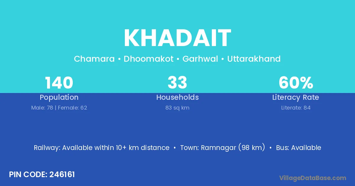
Khadait village is located in the Dhoomakot Tehsil of the Garhwal district in Uttarakhand .
Block / Tehsil → Dhoomakot
District → Garhwal
State → Uttarakhand
According to Census 2011 information, the village code of Khadait village is 246161.
Khadait village has a total population of 140 people, of which 78 are males and 62 are females.
The literacy rate of Khadait village is 60.00%. Male literacy stands at 66.67% and female literacy at 51.61%.
There are approximately 33 households in Khadait village.
Ramnagar (98 km) is the nearest town to Khadait village for major economic activities and is located approximately 98 km away.
The population of Khadait village is distributed between literate and illiterate residents as follows:
| Particulars | Male | Female | Total |
|---|---|---|---|
| Literate | 52 | 32 | 84 |
| Illiterate | 26 | 30 | 56 |
| Total | 78 | 62 | 140 |
Source: Census 2011
| Village | District |
|---|---|
| Chamara | Anand |
| Chamara | Garhwal |
| Kandi Malli | Garhwal |
| Kandi Malli | Garhwal |
| Kandi Malli | Tehri Garhwal |
| Kandi Talli | Garhwal |
| Kandi Talli | Garhwal |
| Kandi Talli | Tehri Garhwal |
| Kefaltanda | Garhwal |
| Maheli Walli | Garhwal |
| Mekhana | Garhwal |
| Muchhiyal Gaon | Garhwal |
| Otinda Gaon | Garhwal |
| Pholtanda | Garhwal |
| Semri Talli | Garhwal |
| Sila Malla | Garhwal |
| Sila Malla | Garhwal |
| Sila Malla | Garhwal |
No reviews yet. Be the first to review this village!
Available within 10+ km distance
Available within 5 - 10 km distance
Available within 5 - 10 km distance