Puraula: A Town and Tehsil in Uttarkashi district
District → Uttarkashi
State → Uttarakhand
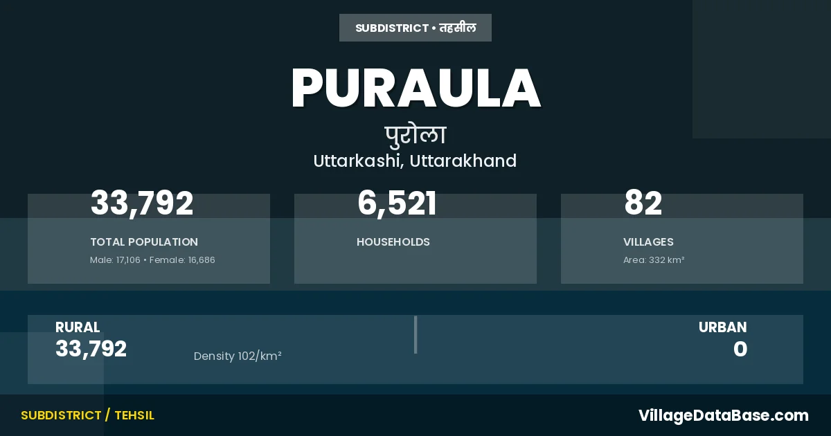
Puraula is a town and Tehsil in the Uttarkashi district of the Uttarakhand. In India, a Tehsil is a subdivision of a district responsible for the administration and revenue collection of a specific area within the district. Tehsils play a crucial role in the local governance structure, contributing significantly to the development and administration of their communities.
According to the 2011 census The total area of Puraula Tehsil is 332 km², with a population of 33792 people. The population density is 102 inhabitants per square kilometre, and there are approximately 6521 houses in the sub district.
Puraula Tehsil comprises about 82 villages. Below is a list of these villages along with information about their respective gram panchayats and the nearest town:
| # | Village Name | Gram Panchayat | Nearest Town |
|---|---|---|---|
| 1 | Angora | Dhundada | Barkot (30 km) |
| 2 | Bandiyar | Barkot (70 km) | |
| 3 | Besti Palli | Veshti Palli | Barkot (40 km) |
| 4 | Bestiwalli | Veshti Palli | Barkot (40 km) |
| 5 | Bhadrali | Khadkyasem | Barkot (36 km) |
| 6 | Bhankoli | Bhankoli | Barkot (35 km) |
| 7 | Binai | Vinai | Barkot (32 km) |
| 8 | Bingadhera Malla | Bingadhera Malla | Barkot (18 km) |
| 9 | Bingadhera Talla | Bingadhera Malla | Barkot (18 km) |
| 10 | Chandeli | Chandeli | Barkot (23 km) |
| 11 | Chaptari | Chaptadi | Barkot (27 km) |
| 12 | Chhamrotta | Chhamrota | Barkot (30 km) |
| 13 | Chhanika | Pounti | Barkot (70 km) |
| 14 | Chhara | Kurda | Barkot (32 km) |
| 15 | Chhiwala | Devdhung | Barkot (30 km) |
| 16 | Darmara | Mairana | Barkot (30 km) |
| 17 | Devdhung | Devdhung | Barkot (30 km) |
| 18 | Dhakaraa | Dhakada | Barkot (35 km) |
| 19 | Dhampur | Koti | Barkot (32 km) |
| 20 | Dhikal Gaon | Nagjhala | Barkot (37 km) |
| 21 | Dhundada | Dhundada | Barkot (33 km) |
| 22 | Dhyoralagakhadkyasem | Ghewra | Barkot (36 km) |
| 23 | Dhyoralagasunali | Ghewra | Barkot (36 km) |
| 24 | Digari | Sar | Barkot (60 km) |
| 25 | Dokhari | Mahargaon | Barkot (42 km) |
| 26 | Dokhariyani | Raun | Barkot (42 km) |
| 27 | Dukra | Nagjhala | Barkot (35 km) |
| 28 | Gaind | Saundari | Barkot (20 km) |
| 29 | Gaul | Pounti | Barkot (70 km) |
| 30 | Gundiyar Gaon | Gundiyatgaon | Barkot (39 km) |
| 31 | Hudoli | Hudoli | Barkot (18 km) |
| 32 | Kamra | Sankhal | Barkot (38 km) |
| 33 | Kandiyal Gaon | Kandiyalgaon | Barkot (36 km) |
| 34 | Kantari | Kantadi | Barkot (34 km) |
| 35 | Karara | Karada | Barkot (32 km) |
| 36 | Kaslaun | Kimdar | Barkot (75 km) |
| 37 | Khablisera | Barkot (29 km) | |
| 38 | Khalari | Khaladi | Barkot (27 km) |
| 39 | Kharkyasem | Khadkyasem | Barkot (36 km) |
| 40 | Kimdar | Kimdar | Barkot (65 km) |
| 41 | Korana | Korna | Barkot (34 km) |
| 42 | Koti | Koti | Barkot (31 km) |
| 43 | Kufara | Dhakada | Barkot (36 km) |
| 44 | Kumarkot | Math | Barkot (36 km) |
| 45 | Kumola | Kumola | Barkot (34 km) |
| 46 | Kurara | Kurda | Barkot (31 km) |
| 47 | Lamkoti | Mahargaon | Barkot (39 km) |
| 48 | Lewtari | Sar | Barkot (65 km) |
| 49 | Mahargaon | Mahargaon | Barkot (37 km) |
| 50 | Mairiyara | Mairana | Barkot (33 km) |
| 51 | Makhana | Pujeli | Barkot (31 km) |
| 52 | Math | Math | Barkot (34 km) |
| 53 | Molkat | Pujeli | Barkot (30 km) |
| 54 | Moltari | Nagjhala | Barkot (32 km) |
| 55 | Moltari Rajputonki | Math | Barkot (38 km) |
| 56 | Nagjhala | Nagjhala | Barkot (37 km) |
| 57 | Naladi | Vinai | Barkot (33 km) |
| 58 | Narasakhal Matiyalaur | Sankhal | Barkot (38 km) |
| 59 | Nauri | Nauri | Barkot (36 km) |
| 60 | Netri | Netri | Barkot (28 km) |
| 61 | Pani Gaon | Panigaon | Barkot (18 km) |
| 62 | Paunti | Pounti | Barkot (70 km) |
| 63 | Pora | Pora | Barkot (36 km) |
| 64 | Pujeli | Pujeli | Barkot (34 km) |
| 65 | Purola | Barkot (30 km) | |
| 66 | Purola Range | Barkot (57 km) | |
| 67 | Puseli | Suranukiseri | Barkot (34 km) |
| 68 | Rama Gaon | Rama | Barkot (40 km) |
| 69 | Rateri | Mairana | Barkot (38 km) |
| 70 | Raun | Raun | Barkot (39 km) |
| 71 | Sar Gaon | Sar | Barkot (65 km) |
| 72 | Saundari | Saundari | Barkot (21 km) |
| 73 | Shikaru | Karada | Barkot (35 km) |
| 74 | Shreekot | Shrikot | Barkot (32 km) |
| 75 | Sukdala | Sukdala | Barkot (34 km) |
| 76 | Sunali | Sunali | Barkot (35 km) |
| 77 | Suranukiseri | Suranukiseri | Barkot (40 km) |
| 78 | Sweel | Sweel | Barkot (28 km) |
| 79 | Syaluka | Syaluka | Barkot (42 km) |
| 80 | Thadung | Thadhung | Barkot (19 km) |
| 81 | Thakrari | Korna | Barkot (32 km) |
| 82 | Thali | Thali | Barkot (20 km) |
The population is distributed between urban and rural areas as follows:
| Particulars | Rural | Urban | Total |
|---|---|---|---|
| Total Population | 33792 | 0 | 33792 |
| Male Population | 17106 | 0 | 17106 |
| Female Population | 16686 | 0 | 16686 | Population Density | 102 / km² | 102 / km² |
The distribution of households in the Puraula is:
| Rural Households | Urban Households | Total Households |
|---|---|---|
| 6521 | 0 | 6521 |
Q: What is Puraula?
A: Puraula is a town and in the Uttarkashi district of the Uttarakhand.
Q: What is the total area of Puraula Tehsil?
A: The total area of Puraula Tehsil is 332 km².
Q: What is the population of Puraula Tehsil according to the 2011 census?
A: According to the 2011 census, the population of Puraula Tehsil is 33792.
Q: What is the population density of Puraula Tehsil?
A: The population density of Puraula Tehsil is 102 inhabitants per square kilometre.
Q: How many houses are there in Puraula Tehsil?
A: There are approximately 6521 houses in Puraula Tehsil.
Q: How many villages are there in Puraula Tehsil?
A: There are about 82 villages in Puraula Tehsil.
Q: Which is the largest village by population in Puraula Tehsil?
A: The largest village by population in Puraula Tehsil is Purola, with 2394 people.
Q: Which is the smallest village by population in Puraula Tehsil?
A: The smallest village by population in Puraula Tehsil is Bandiyar, with 2 people.
Q: Which is the largest village by area in Puraula Tehsil?
A: The largest village by area in Puraula Tehsil is Purola Range, with 15890 km².
Q: Which is the smallest village by area in Puraula Tehsil?
A: The smallest village by area in Puraula Tehsil is Kumarkot, with 9 km².
Q: What is the population distribution between urban and rural areas in Puraula Tehsil?
A: The population distribution in Puraula Tehsil is entirely rural, with a total rural population of 33792.
Q: What is the male population of Puraula Tehsil?
A: The male population of Puraula Tehsil is 17106.
Q: What is the female population of Puraula Tehsil?
A: The female population of Puraula Tehsil is 16686.
Q: How is the household distribution in Puraula Tehsil?
A: The household distribution in Puraula Tehsil is entirely rural, with a total of 6521 households.
Q: How many villages in Puraula Tehsil have a population of less than 100?
A: There are 10 villages in Puraula Tehsil with a population of less than 100.
Q: How many villages in Puraula Tehsil have a population between 100 and 499?
A: There are 48 villages in Puraula Tehsil with a population between 100 and 499.
Q: How many villages in Puraula Tehsil have a population between 500 and 999?
A: There are 18 villages in Puraula Tehsil with a population between 500 and 999.
Q: How many villages in Puraula Tehsil have a population between 1000 and 1999?
A: There are 4 villages in Puraula Tehsil with a population between 1000 and 1999.
Q: How many villages in Puraula Tehsil have a population between 2000 and 2999?
A: There is 2 village in Puraula Tehsil with a population between 2000 and 2999.
| Total Population | Villages in Sub District Of Puraula |
|---|---|
| Less than 100 | 10 |
| 100-499 | 48 |
| 500-999 | 18 |
| 1000-1999 | 4 |
| 2000-2999 | 2 |