Amruthalur: A Town and Mandal in Guntur district
District → Guntur
State → Andhra Pradesh
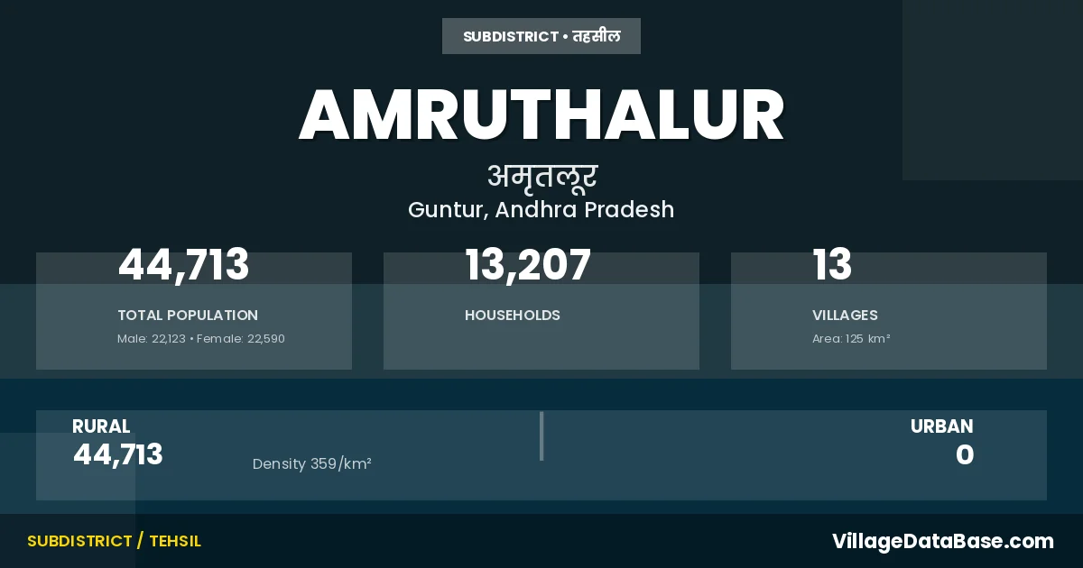
Amruthalur is a town and Mandal in the Guntur district of the Andhra Pradesh. In India, a Mandal is a subdivision of a district responsible for the administration and revenue collection of a specific area within the district. Mandals play a crucial role in the local governance structure, contributing significantly to the development and administration of their communities.
According to the 2011 census The total area of Amruthalur Mandal is 125 km², with a population of 44713 people. The population density is 359 inhabitants per square kilometre, and there are approximately 13207 houses in the sub district.
Amruthalur Mandal comprises about 13 villages. Below is a list of these villages along with information about their respective gram panchayats and the nearest town:
| # | Village Name | Gram Panchayat | Nearest Town |
|---|---|---|---|
| 1 | Amruthalur | Amruthalur | Tenali (17 km) |
| 2 | Bodapadu | Bodapadu | Ponnur (6 km) |
| 3 | Govada | Govada | Tenali (20 km) |
| 4 | Intur | Intur | Ponnur (8 km) |
| 5 | Koditadiparru | Korutadiparru | Tenali (15 km) |
| 6 | Kuchipudi | Kuchipudi | Tenali (14 km) |
| 7 | Moparru | Moparru | Tenali (17 km) |
| 8 | Mulpur | Mulpur | Tenali (10 km) |
| 9 | Panchalavaram | Panchalavaram | Tenali (20 km) |
| 10 | Peddapudi | Pedapudi | Tenali (10 km) |
| 11 | Pyaparru | Pyaparru | Ponnur (8 km) |
| 12 | Thurumella | Turumella | Tenali (20 km) |
| 13 | Yelavarru | Yelavarru | Tenali (20 km) |
The population is distributed between urban and rural areas as follows:
| Particulars | Rural | Urban | Total |
|---|---|---|---|
| Total Population | 44713 | 0 | 44713 |
| Male Population | 22123 | 0 | 22123 |
| Female Population | 22590 | 0 | 22590 | Population Density | 359 / km² | 359 / km² |
The distribution of households in the Amruthalur is:
| Rural Households | Urban Households | Total Households |
|---|---|---|
| 13207 | 0 | 13207 |
Q: What is Amruthalur?
A: Amruthalur is a town and in the Guntur district of the Andhra Pradesh.
Q: What is the total area of Amruthalur Mandal?
A: The total area of Amruthalur Mandal is 125 km².
Q: What is the population of Amruthalur Mandal according to the 2011 census?
A: According to the 2011 census, the population of Amruthalur Mandal is 44713.
Q: What is the population density of Amruthalur Mandal?
A: The population density of Amruthalur Mandal is 359 inhabitants per square kilometre.
Q: How many houses are there in Amruthalur Mandal?
A: There are approximately 13207 houses in Amruthalur Mandal.
Q: How many villages are there in Amruthalur Mandal?
A: There are about 13 villages in Amruthalur Mandal.
Q: Which is the largest village by population in Amruthalur Mandal?
A: The largest village by population in Amruthalur Mandal is Kuchipudi, with 6788 people.
Q: Which is the smallest village by population in Amruthalur Mandal?
A: The smallest village by population in Amruthalur Mandal is Koditadiparru, with 757 people.
Q: Which is the largest village by area in Amruthalur Mandal?
A: The largest village by area in Amruthalur Mandal is Intur, with 2184 km².
Q: Which is the smallest village by area in Amruthalur Mandal?
A: The smallest village by area in Amruthalur Mandal is Bodapadu, with 350 km².
Q: What is the population distribution between urban and rural areas in Amruthalur Mandal?
A: The population distribution in Amruthalur Mandal is entirely rural, with a total rural population of 44713.
Q: What is the male population of Amruthalur Mandal?
A: The male population of Amruthalur Mandal is 22123.
Q: What is the female population of Amruthalur Mandal?
A: The female population of Amruthalur Mandal is 22590.
Q: How is the household distribution in Amruthalur Mandal?
A: The household distribution in Amruthalur Mandal is entirely rural, with a total of 13207 households.
Q: How many villages in Amruthalur Mandal have a population between 500 and 999?
A: There are 1 villages in Amruthalur Mandal with a population between 500 and 999.
Q: How many villages in Amruthalur Mandal have a population between 1000 and 1999?
A: There are 3 villages in Amruthalur Mandal with a population between 1000 and 1999.
Q: How many villages in Amruthalur Mandal have a population between 2000 and 2999?
A: There is 2 village in Amruthalur Mandal with a population between 2000 and 2999.
Q: How many villages in Amruthalur Mandal have a population between 3000 and 3999?
A: There is 3 village in Amruthalur Mandal with a population between 3000 and 3999.
Q: How many villages in Amruthalur Mandal have a population of 5000 and above?
A: There is 4 village in Amruthalur Mandal with a population of 5000 and above.
| Total Population | Villages in Sub District Of Amruthalur |
|---|---|
| 500-999 | 1 |
| 1000-1999 | 3 |
| 2000-2999 | 2 |
| 3000-3999 | 3 |
| 5000 And Above | 4 |