
Amaravathi village is located in the Kalidindi Mandal of the Krishna district in Andhra Pradesh .
Block / Mandal → Kalidindi
District → Krishna
State → Andhra Pradesh
According to Census 2011 information, the village code of Amaravathi village is 521344.
Amaravathi village has a total population of 1,463 people, of which 699 are males and 764 are females.
The literacy rate of Amaravathi village is 49.83%. Male literacy stands at 56.37% and female literacy at 43.85%.
There are approximately 410 households in Amaravathi village.
Bhimavaram (30 km) is the nearest town to Amaravathi village for major economic activities and is located approximately 30 km away.
The population of Amaravathi village is distributed between literate and illiterate residents as follows:
| Particulars | Male | Female | Total |
|---|---|---|---|
| Literate | 394 | 335 | 729 |
| Illiterate | 305 | 429 | 734 |
| Total | 699 | 764 | 1,463 |
Source: Census 2011
| Village | District |
|---|---|
| Avakuru | Krishna |
| Kalidindi | Krishna |
| Komallapudi | Krishna |
| Komallapudi | Visakhapatnam |
| Kondangi | Krishna |
| Kondangi | Koriya |
| Kondangi | Kancheepuram |
| Kondangi | Viluppuram |
| Korukollu | Krishna |
| Korukollu | West Godavari |
| Kotcherla | Guntur |
| Kotcherla | Krishna |
| Kotcherla | Srikakulam |
| Mattagunta | Krishna |
| Munipeda | Krishna |
| Neelipudi | Krishna |
| Pedalanka | Guntur |
| Pedalanka | Guntur |
| Pedalanka | Krishna |
| Pedalanka | Visakhapatnam |
| Pedalanka | Malkangiri |
| Sana Rudravaram | Krishna |
Showing 1 of 1 places
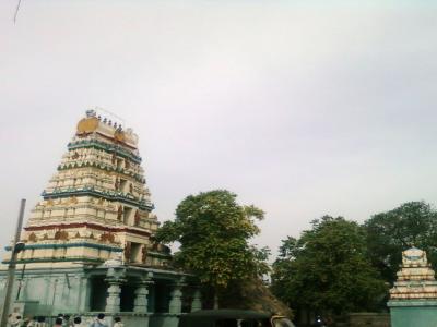
The Amaralingeswara Swamy Temple, Andhra Pradesh is a prominent Temple dedicated to Lord Shiva located in Amaravathi, K
No reviews yet. Be the first to review this village!
Available within 5 - 10 km distance
Available within village
Available within 5 - 10 km distance