District → Lohit
State → Arunachal Pradesh
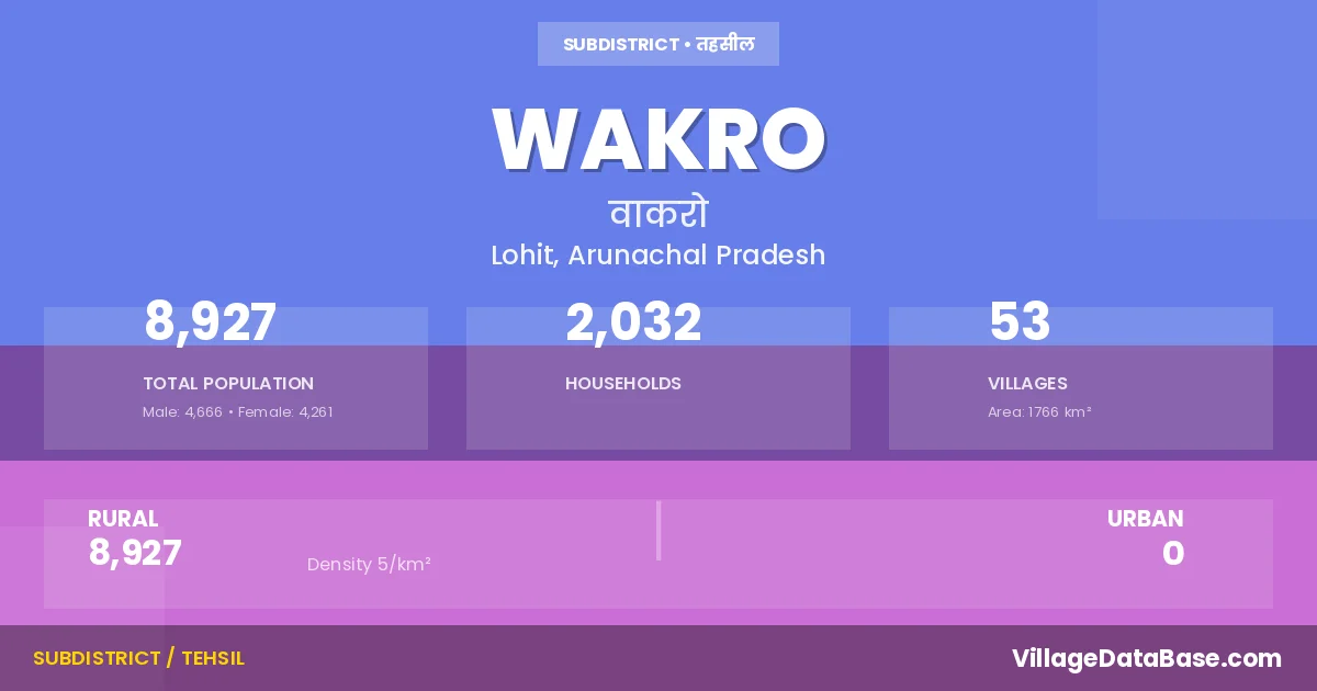
Wakro is a town and Circle in the Lohit district of the Arunachal Pradesh. In India, a Circle is a subdivision of a district responsible for the administration and revenue collection of a specific area within the district. Circles play a crucial role in the local governance structure, contributing significantly to the development and administration of their communities.
According to the 2011 census The total area of Wakro Circle is 1766 km², with a population of 8927 people. The population density is 5 inhabitants per square kilometre, and there are approximately 2032 houses in the sub district.
Wakro Circle comprises about 53 villages. Below is a list of these villages along with information about their respective gram panchayats and the nearest town:
| # | Village Name | Gram Panchayat | Nearest Town |
|---|---|---|---|
| 1 | Babruliang | Namsai (46 km) | |
| 2 | Chereng | Tezu (58 km) | |
| 3 | Chikroglat | Tezu (105 km) | |
| 4 | Chikrolang | Namsai (70 km) | |
| 5 | Cibi | Tezu (68 km) | |
| 6 | Gundri | Tezu (59 km) | |
| 7 | Hallao | Tezu (61 km) | |
| 8 | Huking | Hooking | Namsai (44 km) |
| 9 | Kalai | Wakro | |
| 10 | Kamban | Namsai (99 km) | |
| 11 | Kamja | Kamja Towam | Namsai (66 km) |
| 12 | Kamlang Nagar | Namsai (62 km) | |
| 13 | Kandey | Tezu (46 km) | |
| 14 | Kanjang | Kanjang | Tezu (58 km) |
| 15 | Karhe | Karhe | Tezu (68 km) |
| 16 | Kathan | Tezu (108 km) | |
| 17 | Lamliang | Namsai (47 km) | |
| 18 | Longbin | Tezu (74 km) | |
| 19 | Manthi | Tezu (84 km) | |
| 20 | Manyu Tea Estate | Namsai (47 km) | |
| 21 | Manyuliang | Namsai (45 km) | |
| 22 | Maruba | Tezu (61 km) | |
| 23 | Mawai I | Mawai I | Tezu (48 km) |
| 24 | Mawai Ii | Tezu (49 km) | |
| 25 | Medo Camp | Medo | Namsai (45 km) |
| 26 | Medo Tea Corporation | Medo | Namsai (42 km) |
| 27 | Medo Village | Medo | Namsai (46 km) |
| 28 | Mining Nagar | Namsai (65 km) | |
| 29 | Namgo | Namgo | Namsai (68 km) |
| 30 | New Phukari | Tezu (52 km) | |
| 31 | New Tumba | Namsai (103 km) | |
| 32 | Ngatai | Tezu (45 km) | |
| 33 | Paleng | Wakro | |
| 34 | Parsuram Kund | Tezu (44 km) | |
| 35 | Phukari | Pukhri | Tezu (53 km) |
| 36 | Proshi | Namsai (80 km) | |
| 37 | Samblu | Namsai (69 km) | |
| 38 | Tahar | Tezu (81 km) | |
| 39 | Tapun | Tezu (105 km) | |
| 40 | Tarungalt | Namsai (51 km) | |
| 41 | Teplang | Tezu (109 km) | |
| 42 | Thowang | Kamja Towam | Tezu (85 km) |
| 43 | Tihun | Wakro | |
| 44 | Tillai | Tillai | Tezu (83 km) |
| 45 | Tillai Camp | Tillai | Namsai (82 km) |
| 46 | Tillang Kyong | Tezu (104 km) | |
| 47 | Tissue | Namsai (96 km) | |
| 48 | Topo | Tezu (86 km) | |
| 49 | Towam | Kamja Towam | Tezu (65 km) |
| 50 | Tumba | Namsai (103 km) | |
| 51 | Waikhetliang | Waikhetliang Dabrumliang | Namsai (50 km) |
| 52 | Wakro H Q | Wakro | Tezu (60 km) |
| 53 | Wakro Village | Wakro | Tezu (60 km) |
The population is distributed between urban and rural areas as follows:
| Particulars | Rural | Urban | Total |
|---|---|---|---|
| Total Population | 8927 | 0 | 8927 |
| Male Population | 4666 | 0 | 4666 |
| Female Population | 4261 | 0 | 4261 | Population Density | 5 / km² | 5 / km² |
The distribution of households in the Wakro is:
| Rural Households | Urban Households | Total Households |
|---|---|---|
| 2032 | 0 | 2032 |
Q: What is Wakro?
A: Wakro is a town and in the Lohit district of the Arunachal Pradesh.
Q: What is the total area of Wakro Circle?
A: The total area of Wakro Circle is 1766 km².
Q: What is the population of Wakro Circle according to the 2011 census?
A: According to the 2011 census, the population of Wakro Circle is 8927.
Q: What is the population density of Wakro Circle?
A: The population density of Wakro Circle is 5 inhabitants per square kilometre.
Q: How many houses are there in Wakro Circle?
A: There are approximately 2032 houses in Wakro Circle.
Q: How many villages are there in Wakro Circle?
A: There are about 53 villages in Wakro Circle.
Q: Which is the largest village by population in Wakro Circle?
A: The largest village by population in Wakro Circle is Wakro H Q, with 1215 people.
Q: Which is the smallest village by population in Wakro Circle?
A: The smallest village by population in Wakro Circle is Kalai, with 0 people.
Q: Which is the largest village by area in Wakro Circle?
A: The largest village by area in Wakro Circle is Babruliang, with 0 km².
Q: Which is the smallest village by area in Wakro Circle?
A: The smallest village by area in Wakro Circle is Babruliang, with 0 km².
Q: What is the population distribution between urban and rural areas in Wakro Circle?
A: The population distribution in Wakro Circle is entirely rural, with a total rural population of 8927.
Q: What is the male population of Wakro Circle?
A: The male population of Wakro Circle is 4666.
Q: What is the female population of Wakro Circle?
A: The female population of Wakro Circle is 4261.
Q: How is the household distribution in Wakro Circle?
A: The household distribution in Wakro Circle is entirely rural, with a total of 2032 households.
Q: How many villages in Wakro Circle have a population of less than 100?
A: There are 27 villages in Wakro Circle with a population of less than 100.
Q: How many villages in Wakro Circle have a population between 100 and 499?
A: There are 22 villages in Wakro Circle with a population between 100 and 499.
Q: How many villages in Wakro Circle have a population between 500 and 999?
A: There are 2 villages in Wakro Circle with a population between 500 and 999.
Q: How many villages in Wakro Circle have a population between 1000 and 1999?
A: There are 2 villages in Wakro Circle with a population between 1000 and 1999.
| Total Population | Villages in Sub District Of Wakro |
|---|---|
| Less than 100 | 27 |
| 100-499 | 22 |
| 500-999 | 2 |
| 1000-1999 | 2 |