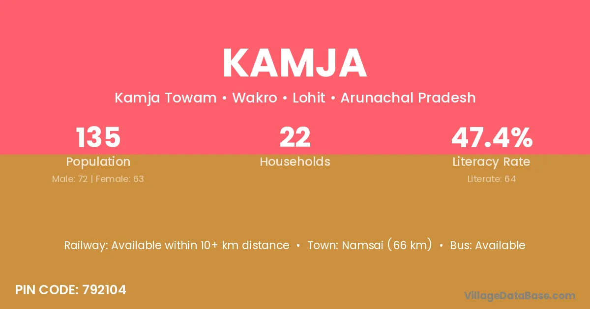
Kamja village is located in the Wakro Circle of the Lohit district in Arunachal Pradesh .
Block / Circle → Wakro
District → Lohit
State → Arunachal Pradesh
According to Census 2011 information, the village code of Kamja village is 792104.
Kamja village has a total population of 135 people, of which 72 are males and 63 are females.
The literacy rate of Kamja village is 47.41%. Male literacy stands at 61.11% and female literacy at 31.75%.
There are approximately 22 households in Kamja village.
Namsai (66 km) is the nearest town to Kamja village for major economic activities and is located approximately 66 km away.
The population of Kamja village is distributed between literate and illiterate residents as follows:
| Particulars | Male | Female | Total |
|---|---|---|---|
| Literate | 44 | 20 | 64 |
| Illiterate | 28 | 43 | 71 |
| Total | 72 | 63 | 135 |
Source: Census 2011
| Village | District |
|---|---|
| Chereng | Lohit |
| Cibi | Lohit |
| Kalai | Anjaw |
| Kalai | Lohit |
| Kalai | Munger |
| Kalai | Raipur |
| Kalai | Valsad |
| Kalai | Mandi |
| Kalai | Punch |
| Kalai | Raigarh |
| Kalai | Aligarh |
| Kalai | Rudraprayag |
| Kalai | Purba Medinipur |
| Kalai | Purba Medinipur |
| Kamban | Lohit |
| Karhe | Lohit |
| Karhe | Ahmadnagar |
| Karhe | Nashik |
| Karhe | Thane |
| Manthi | Lohit |
| Mining Nagar | Lohit |
| New Tumba | Lohit |
| Paleng | Lohit |
| Tihun | Lohit |
| Tumba | Lohit |
| Tumba | Rohtas |
| Tumba | Hazaribagh |
| Tumba | Bagalkot |
| Tumba | Neemuch |
| Tumba | Rayagada |
| Tumba | Chittaurgarh |
| Tumba | Chittaurgarh |
| Tumba | Puruliya |
| Tumba | Puruliya |
No reviews yet. Be the first to review this village!
Available within 10+ km distance
Available within <5 km distance
Available within <5 km distance