Uttar Pradesh are divided into 71 districts for administrative purposes. Heres a closer look at each:
| # | District | Area (km²) | Population (2011) | Density (km²) |
|---|---|---|---|---|
| 1 | Agra | 4041 | 4418797 | 1093 |
| 2 | Aligarh | 3650 | 3673889 | 1007 |
| 3 | Allahabad | 5482 | 5954391 | 1086 |
| 4 | Ambedkar Nagar | 2350 | 2397888 | 1020 |
| 5 | Auraiya | 2016 | 1379545 | 684 |
| 6 | Azamgarh | 4054 | 4613913 | 1138 |
| 7 | Baghpat | 1321 | 1303048 | 986 |
| 8 | Bahraich | 5237 | 3487731 | 666 |
| 9 | Ballia | 2981 | 3239774 | 1087 |
| 10 | Balrampur | 3349 | 2148665 | 642 |
| 11 | Banda | 4408 | 1799410 | 408 |
| 12 | Bara Banki | 4402 | 3260699 | 741 |
| 13 | Bareilly | 4120 | 4448359 | 1080 |
| 14 | Basti | 2688 | 2464464 | 917 |
| 15 | Bijnor | 4561 | 3682713 | 807 |
| 16 | Budaun | 5168 | 3681896 | 712 |
| 17 | Bulandshahr | 4512 | 3499171 | 776 |
| 18 | Chandauli | 2541 | 1952756 | 768 |
| 19 | Chitrakoot | 3216 | 991730 | 308 |
| 20 | Deoria | 2540 | 3100946 | 1221 |
| 21 | Etah | 2431 | 1774480 | 730 |
| 22 | Etawah | 2311 | 1581810 | 684 |
| 23 | Faizabad | 2341 | 2470996 | 1056 |
| 24 | Farrukhabad | 2181 | 1885204 | 864 |
| 25 | Fatehpur | 4152 | 2632733 | 634 |
| 26 | Firozabad | 2407 | 2498156 | 1038 |
| 27 | Gautam Buddha Nagar | 1282 | 1648115 | 1286 |
| 28 | Ghaziabad | 1179 | 4681645 | 3971 |
| 29 | Ghazipur | 3377 | 3620268 | 1072 |
| 30 | Gonda | 4003 | 3433919 | 858 |
| 31 | Gorakhpur | 3321 | 4440895 | 1337 |
| 32 | Hamirpur | 4021 | 1104285 | 275 |
| 33 | Hardoi | 5986 | 4092845 | 684 |
| 34 | Jalaun | 4565 | 1689974 | 370 |
| 35 | Jaunpur | 4038 | 4494204 | 1113 |
| 36 | Jhansi | 5024 | 1998603 | 398 |
| 37 | Jyotiba Phule Nagar | 2249 | 1840221 | 818 |
| 38 | Kannauj | 2093 | 1656616 | 792 |
| 39 | Kanpur Dehat | 3021 | 1796184 | 595 |
| 40 | Kanpur Nagar | 3155 | 4581268 | 1452 |
| 41 | Kanshiram Nagar | 1955 | 1436719 | 735 |
| 42 | Kaushambi | 1779 | 1599596 | 899 |
| 43 | Kheri | 7680 | 4021243 | 524 |
| 44 | Kushinagar | 2905 | 3564544 | 1227 |
| 45 | Lalitpur | 5039 | 1221592 | 242 |
| 46 | Lucknow | 2528 | 4589838 | 1816 |
| 47 | Mahamaya Nagar | 1840 | 1564708 | 850 |
| 48 | Mahoba | 3144 | 875958 | 279 |
| 49 | Mahrajganj | 2952 | 2684703 | 909 |
| 50 | Mainpuri | 2760 | 1868529 | 677 |
| 51 | Mathura | 3340 | 2547184 | 763 |
| 52 | Mau | 1713 | 2205968 | 1288 |
| 53 | Meerut | 2559 | 3443689 | 1346 |
| 54 | Mirzapur | 4405 | 2496970 | 567 |
| 55 | Moradabad | 3718 | 4772006 | 1283 |
| 56 | Muzaffarnagar | 4008 | 4143512 | 1034 |
| 57 | Pilibhit | 3686 | 2031007 | 551 |
| 58 | Pratapgarh | 3717 | 3209141 | 863 |
| 59 | Rae Bareli | 4609 | 3405559 | 739 |
| 60 | Rampur | 2367 | 2335819 | 987 |
| 61 | Saharanpur | 3689 | 3466382 | 940 |
| 62 | Sant Kabir Nagar | 1646 | 1715183 | 1042 |
| 63 | Sant Ravidas Nagar | 1015 | 1578213 | 1555 |
| 64 | Shahjahanpur | 4388 | 3006538 | 685 |
| 65 | Shrawasti | 1640 | 1117361 | 681 |
| 66 | Siddharthnagar | 2895 | 2559297 | 884 |
| 67 | Sitapur | 5743 | 4483992 | 781 |
| 68 | Sonbhadra | 6905 | 1862559 | 270 |
| 69 | Sultanpur | 4436 | 3797117 | 856 |
| 70 | Unnao | 4558 | 3108367 | 682 |
| 71 | Varanasi | 1535 | 3676841 | 2395 |
The population is distributed between urban and rural areas as follows:
| Particulars | Rural | Urban | Total |
|---|---|---|---|
| Total Population | 155317278 | 44495063 | 199812341 |
| Male Population | 80992995 | 23487515 | 104480510 |
| Female Population | 74324283 | 21007548 | 95331831 |
The distribution of households in the Uttar Pradesh is:
| Rural Households | Urban Households | Total Households |
|---|---|---|
| 25685942 | 7762093 | 33448035 |
Showing 3 of 8 places
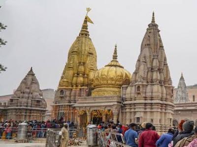
Kashi Vishwanath Temple in Varanasi is one of the most sacred Hindu temples, dedicated to Lord Shiva. Situated on the banks of the holy Ganga River, it is among the twelve Jyotirlingas and holds immense spiritual significance.
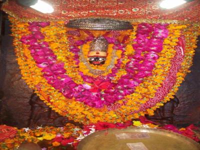
The Vindhyavasini is a prominent Temple dedicated to Goddess Durga located in Vindhyachalpur, Kushinagar, Uttar Pradesh
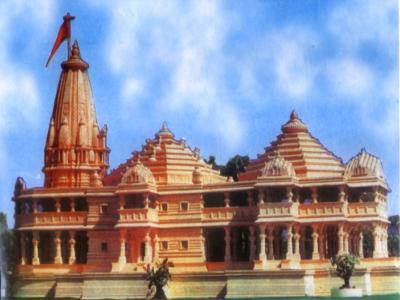
The Ram Janmabhoomi, Ayodhya, Uttar Pradesh is a prominent Temple dedicated to Lord Ram located in Gopalpur Ayodhya, Am
Q: What is the capital of the Uttar Pradesh?
A: The capital of the Uttar Pradesh is Lucknow.
Q: When were the Uttar Pradesh established as a Union Territory or State?
A: The Uttar Pradesh were established as a Union Territory or State on 26-Jan-1950.
Q: How many districts are there in the Uttar Pradesh?
A: There are 71 districts in the Uttar Pradesh .
Q: What is the largest district by area in the Uttar Pradesh?
A: The largest district by area in the Uttar Pradesh is Kheri, with an area of 7680 km².
Q: Which district in the Uttar Pradesh has the largest population?
A: The district with the largest population in the Uttar Pradesh is Allahabad, with a population of 5954391 people.
Q: What is the total area of the Uttar Pradesh?
A: The total area of the Uttar Pradesh is 240928 km².
Q: What is the total population of the Uttar Pradesh according to the 2011 census?
A: According to the 2011 census, the total population of the Uttar Pradesh is 199812341.
Q: Which high court has jurisdiction over the Uttar Pradesh?
A: The Allahabad High Court has jurisdiction over the Uttar Pradesh.
Q: How is the population distributed between urban and rural areas in the Uttar Pradesh?
A: The population distribution in the Uttar Pradesh is as follows:
Q: How many households are there in the Uttar Pradesh?
A: There are 33448035 households in the Uttar Pradesh.
Q: What are the population ranges of villages in the Uttar Pradesh?
A: The population ranges of villages in the Uttar Pradesh are:
Q: How is the male and female population distributed in the Uttar Pradesh?
A: The population distribution by gender in the Uttar Pradesh is as follows:
Q: What is the smallest district by area in the Uttar Pradesh?
A: The smallest district by area in the Uttar Pradesh is Sant Ravidas Nagar, with an area of 1015 km².
Q: Which district in the Uttar Pradesh has the smallest population?
A: The district with the smallest population in the Uttar Pradesh is Mahoba, with a population of 875958 people.
Q: What are Union Territories or States in the Northern Region of India?
A: Union Territories or States in the Northern Region of India include:
| Total Population | Villages in Sub District Of Uttar Pradesh |
|---|---|
| Less than 100 | 13211 |
| 100-499 | 16443 |
| 500-999 | 22634 |
| 1000-1999 | 27275 |
| 2000-2999 | 12254 |
| 3000-3999 | 5544 |
| 4000-4999 | 2835 |
| 5000 And Above | 3943 |