Sarupeta: A Town and Subdivision in Barpeta district
District → Barpeta
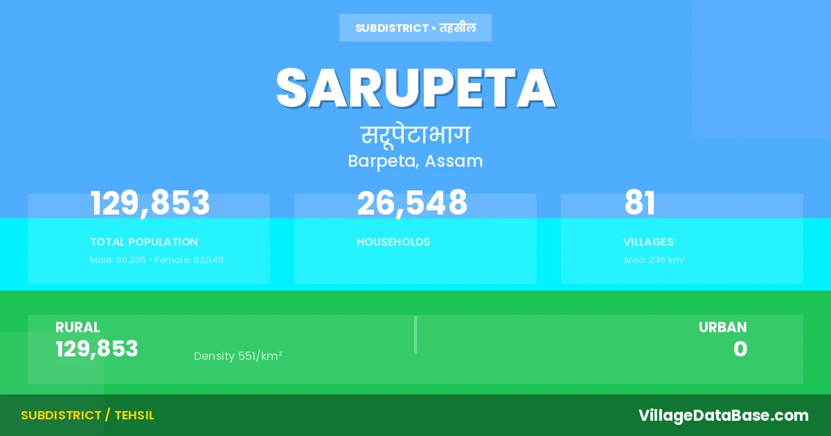
State → Assam
Sarupeta is a town and Subdivision in the Barpeta district of the Assam. In India, a Subdivision is a subdivision of a district responsible for the administration and revenue collection of a specific area within the district. Subdivisions play a crucial role in the local governance structure, contributing significantly to the development and administration of their communities.
According to the 2011 census The total area of Sarupeta Subdivision is 236 km², with a population of 129853 people. The population density is 551 inhabitants per square kilometre, and there are approximately 26548 houses in the sub district.
Sarupeta Subdivision comprises about 81 villages. Below is a list of these villages along with information about their respective gram panchayats and the nearest town:
| # | Village Name | Gram Panchayat | Nearest Town |
|---|---|---|---|
| 1 | Ananda Pur | Sukmanath | Sarupeta |
| 2 | Bagimari | Sarupeta | Sarupeta |
| 3 | Bagula Para | Singimari | Pathsala (14 km) |
| 4 | Bamunkutani | Singimari | Pathsala (15 km) |
| 5 | Bangli Para | Kalbari | Pathsala (10 km) |
| 6 | Bangti | Chauliabari | Pathsala (23 km) |
| 7 | Batua | Geruapara | Sarupeta |
| 8 | Bhalaguri | Sarupeta | Sarupeta |
| 9 | Bhogpur | Sarupeta | Sarupeta |
| 10 | Borbhitha | Hathinapur | Pathsala (10 km) |
| 11 | Borbori | Geruapara | Sarupeta |
| 12 | Borkur | Hathinapur | Pathsala (7 km) |
| 13 | Botiamari | Dhumarpathar | Pathsala (40 km) |
| 14 | Ceki | Hathinapur | Pathsala (9 km) |
| 15 | Charal Para | Geruapara | Sarupeta |
| 16 | Chaulia Bori | Chauliabari | Pathsala (19 km) |
| 17 | Chengli Mari | Dhumarpathar | Pathsala (25 km) |
| 18 | Chinapatani | Dhumarpathar | Sarupeta |
| 19 | Daira Buri | Niz Bhawanipur | Sarupeta |
| 20 | Dakshin Bhalaguri | Sarupeta | Sarupeta |
| 21 | Dakshin Hati | Niz Bhawanipur | Sarupeta |
| 22 | Dalimar Bhitha | Singimari | Pathsala (19 km) |
| 23 | Darupara | Singimari | Pathsala |
| 24 | Datir Bori | Datirbori | Sarupeta |
| 25 | Dhemchar Pathar | Chauliabari | Pathsala (20 km) |
| 26 | Dhumar Pathar | Dhumarpathar | Sarupeta |
| 27 | Dhupal Para | Galia | Sarupeta |
| 28 | Digjira | Dhumarpathar | Pathsala (19 km) |
| 29 | Dolor Pathar | Hathinapur | Pathsala (15 km) |
| 30 | Galia | Galia | Sarupeta |
| 31 | Gathi Para | Galia | Sarupeta |
| 32 | Gerua Para | Geruapara | Sarupeta |
| 33 | Gomura Gaon | Sarupeta | Sarupeta |
| 34 | Gora Pit | Sarupeta | Sarupeta |
| 35 | Hakar Tup | Singimari | Pathsala (14 km) |
| 36 | Hallang Bari | Dhumarpathar | Pathsala (16 km) |
| 37 | Hari Pur | Galia | Sarupeta |
| 38 | Hathina Pur | Hathinapur | Pathsala (8 km) |
| 39 | Kahara Gaon | Kalbari | Pathsala (10 km) |
| 40 | Kahara Pathar | Kalbari | Pathsala (10 km) |
| 41 | Kalbari | Kalbari | Sarupeta |
| 42 | Karagari | Niz Bhawanipur | Sarupeta |
| 43 | Karagari Pathar | Niz Bhawanipur | Sarupeta |
| 44 | Kathalmuri Ghat | Dhumarpathar | Pathsala (18 km) |
| 45 | Katola | Datirbori | Pathsala (9 km) |
| 46 | Katola Pathar | Datirbori | Pathsala (10 km) |
| 47 | Kotho Bari | Hathinapur | Pathsala (7 km) |
| 48 | Kurobaha Gaon | Kalbari | Pathsala (8 km) |
| 49 | Kurobaha Pathar | Kalbari | Pathsala (8 km) |
| 50 | Luashur | Sarupeta | Sarupeta |
| 51 | Madha Pur | Niz Bhawanipur | Pathsala (40 km) |
| 52 | Madhapur | Dhumarpathar | Sarupeta |
| 53 | Maidhya Kordoi Guri | Chauliabari | Pathsala (20 km) |
| 54 | Maj Gaon | Majgaon | Sarupeta |
| 55 | Medhi Kuchi | Hathinapur | Pathsala (7 km) |
| 56 | Na Kuchi Gaon | Niz Bhawanipur | Sarupeta |
| 57 | Na Kuchi Pathar Naruchi Pathar | Niz Bhawanipur | Sarupeta |
| 58 | Namati | Galia | Sarupeta |
| 59 | Naosarka Pathar | Chauliabari | Pathsala (24 km) |
| 60 | Niz Bhabanipur | Niz Bhawanipur | Pathsala (21 km) |
| 61 | Odalguri | Singimari | Pathsala (8 km) |
| 62 | Pakriguri Pathar | Dhumarpathar | Sarupeta |
| 63 | Pan Para | Dhumarpathar | Pathsala (40 km) |
| 64 | Paschim Kordoi Guri | Chauliabari | Pathsala (22 km) |
| 65 | Pata Gaon | Majgaon | Sarupeta |
| 66 | Pora Bhoral | Sukmanath | Sarupeta |
| 67 | Pub Hati | Niz Bhawanipur | Sarupeta |
| 68 | Pub Kordoiguri | Chauliabari | Pathsala (21 km) |
| 69 | Puran Bhabanipur | Geruapara | Sarupeta |
| 70 | Purbaluasur | Galia | Sarupeta |
| 71 | Puthimari | Singimari | Pathsala (8 km) |
| 72 | Rajakhat | Datirbori | Pathsala (6 km) |
| 73 | Roumari | Majgaon | Sarupeta |
| 74 | Sarupeta Gaon | Sarupeta | Sarupeta |
| 75 | Sarupeta Town | Sarupeta | Sarupeta |
| 76 | Singimari | Singimari | Pathsala (8 km) |
| 77 | Siyalmari | Singimari | Pathsala (8 km) |
| 78 | Soto Kamar | Chauliabari | Pathsala (20 km) |
| 79 | Suk Manah | Sukmanath | Sarupeta |
| 80 | Tangla | Datirbori | Pathsala (6 km) |
| 81 | Tapa | Galia | Sarupeta |
The population is distributed between urban and rural areas as follows:
| Particulars | Rural | Urban | Total |
|---|---|---|---|
| Total Population | 129853 | 0 | 129853 |
| Male Population | 66305 | 0 | 66305 |
| Female Population | 63548 | 0 | 63548 | Population Density | 551 / km² | 551 / km² |
The distribution of households in the Sarupeta is:
| Rural Households | Urban Households | Total Households |
|---|---|---|
| 26548 | 0 | 26548 |
Q: What is Sarupeta?
A: Sarupeta is a town and in the Barpeta district of the Assam.
Q: What is the total area of Sarupeta Subdivision?
A: The total area of Sarupeta Subdivision is 236 km².
Q: What is the population of Sarupeta Subdivision according to the 2011 census?
A: According to the 2011 census, the population of Sarupeta Subdivision is 129853.
Q: What is the population density of Sarupeta Subdivision?
A: The population density of Sarupeta Subdivision is 551 inhabitants per square kilometre.
Q: How many houses are there in Sarupeta Subdivision?
A: There are approximately 26548 houses in Sarupeta Subdivision.
Q: How many villages are there in Sarupeta Subdivision?
A: There are about 81 villages in Sarupeta Subdivision.
Q: Which is the largest village by population in Sarupeta Subdivision?
A: The largest village by population in Sarupeta Subdivision is Suk Manah, with 4775 people.
Q: Which is the smallest village by population in Sarupeta Subdivision?
A: The smallest village by population in Sarupeta Subdivision is Pakriguri Pathar, with 127 people.
Q: Which is the largest village by area in Sarupeta Subdivision?
A: The largest village by area in Sarupeta Subdivision is Pata Gaon, with 807 km².
Q: Which is the smallest village by area in Sarupeta Subdivision?
A: The smallest village by area in Sarupeta Subdivision is Bamunkutani, with 43 km².
Q: What is the population distribution between urban and rural areas in Sarupeta Subdivision?
A: The population distribution in Sarupeta Subdivision is entirely rural, with a total rural population of 129853.
Q: What is the male population of Sarupeta Subdivision?
A: The male population of Sarupeta Subdivision is 66305.
Q: What is the female population of Sarupeta Subdivision?
A: The female population of Sarupeta Subdivision is 63548.
Q: How is the household distribution in Sarupeta Subdivision?
A: The household distribution in Sarupeta Subdivision is entirely rural, with a total of 26548 households.
Q: How many villages in Sarupeta Subdivision have a population between 100 and 499?
A: There are 9 villages in Sarupeta Subdivision with a population between 100 and 499.
Q: How many villages in Sarupeta Subdivision have a population between 500 and 999?
A: There are 19 villages in Sarupeta Subdivision with a population between 500 and 999.
Q: How many villages in Sarupeta Subdivision have a population between 1000 and 1999?
A: There are 26 villages in Sarupeta Subdivision with a population between 1000 and 1999.
Q: How many villages in Sarupeta Subdivision have a population between 2000 and 2999?
A: There is 18 village in Sarupeta Subdivision with a population between 2000 and 2999.
Q: How many villages in Sarupeta Subdivision have a population between 3000 and 3999?
A: There is 7 village in Sarupeta Subdivision with a population between 3000 and 3999.
Q: How many villages in Sarupeta Subdivision have a population between 4000 and 4999?
A: There is 2 village in Sarupeta Subdivision with a population between 4000 and 4999.
| Total Population | Villages in Sub District Of Sarupeta |
|---|---|
| 100-499 | 9 |
| 500-999 | 19 |
| 1000-1999 | 26 |
| 2000-2999 | 18 |
| 3000-3999 | 7 |
| 4000-4999 | 2 |