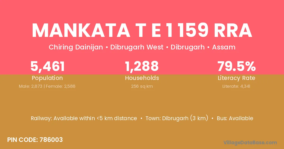
Mankata T E 1 159 Rra village is located in the Dibrugarh West Subdivision of the Dibrugarh district in Assam .
Block / Subdivision → Dibrugarh West
District → Dibrugarh
State → Assam
According to Census 2011 information, the village code of Mankata T E 1 159 Rra village is 786003.
Mankata T E 1 159 Rra village has a total population of 5,461 people, of which 2,873 are males and 2,588 are females.
The literacy rate of Mankata T E 1 159 Rra village is 79.49%. Male literacy stands at 82.77% and female literacy at 75.85%.
There are approximately 1,288 households in Mankata T E 1 159 Rra village.
Dibrugarh (3 km) is the nearest town to Mankata T E 1 159 Rra village for major economic activities and is located approximately 3 km away.
The population of Mankata T E 1 159 Rra village is distributed between literate and illiterate residents as follows:
| Particulars | Male | Female | Total |
|---|---|---|---|
| Literate | 2,378 | 1,963 | 4,341 |
| Illiterate | 495 | 625 | 1,120 |
| Total | 2,873 | 2,588 | 5,461 |
Source: Census 2011
| Village | District |
|---|---|
| Boiragimoth Kachari Gaon | Dibrugarh |
| Chring Gaon | Dibrugarh |
| Dhakeri Gaon | Dibrugarh |
| Gharbondi Chuk Jarua Gaon | Dibrugarh |
| Hatimora Gaon | Dibrugarh |
| Kamar Gaon | Barpeta |
| Kamar Gaon | Dibrugarh |
| Kamar Gaon | Dibrugarh |
| Kamar Gaon | Golaghat |
| Kamar Gaon | Jorhat |
| Kamar Gaon | Kamrup |
| Kamar Gaon | Kamrup Metropolitan |
| Kamar Gaon | Nagaon |
| Kamar Gaon | Nagaon |
| Kamar Gaon | Sonitpur |
| Konwar Handiqui Gaon | Dibrugarh |
| Nagakhalia Gaon | Dibrugarh |
| Suta Bogpara 10 165 | Dibrugarh |
| Tepargaon | Dibrugarh |
| Tingkhong Gaon | Dibrugarh |
No reviews yet. Be the first to review this village!
Available within <5 km distance
Available within village
Available within village