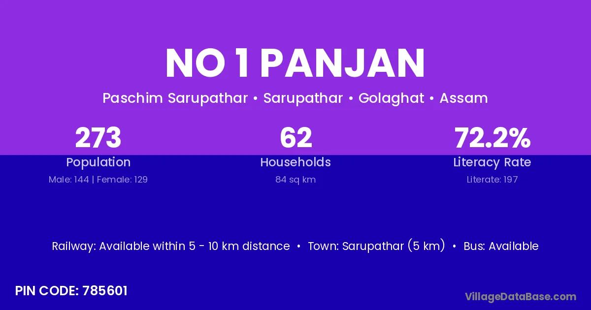
No 1 Panjan village is located in the Sarupathar Subdivision of the Golaghat district in Assam .
Block / Subdivision → Sarupathar
District → Golaghat
State → Assam
According to Census 2011 information, the village code of No 1 Panjan village is 785601.
No 1 Panjan village has a total population of 273 people, of which 144 are males and 129 are females.
The literacy rate of No 1 Panjan village is 72.16%. Male literacy stands at 78.47% and female literacy at 65.12%.
There are approximately 62 households in No 1 Panjan village.
Sarupathar (5 km) is the nearest town to No 1 Panjan village for major economic activities and is located approximately 5 km away.
The population of No 1 Panjan village is distributed between literate and illiterate residents as follows:
| Particulars | Male | Female | Total |
|---|---|---|---|
| Literate | 113 | 84 | 197 |
| Illiterate | 31 | 45 | 76 |
| Total | 144 | 129 | 273 |
Source: Census 2011
| Village | District |
|---|---|
| Borbali | Golaghat |
| Borbali | Golaghat |
| Borbali | Karbi Anglong |
| Borbali | Sonitpur |
| Chukia Pathar | Golaghat |
| Ikorani | Golaghat |
| Kochomari | Golaghat |
| No 1 Rajapukhuri | Golaghat |
| No 2 Kori | Golaghat |
| No 2 Panjan | Golaghat |
| No 2 Rajapukhuri | Golaghat |
| Pan Jan | Golaghat |
| Rengma Gaon | Golaghat |
| Tengabari | Darrang |
| Tengabari | Goalpara |
| Tengabari | Golaghat |
| Tengabari | Sonitpur |
| Tengabari | East Garo Hills |
No reviews yet. Be the first to review this village!
Available within 5 - 10 km distance
Available within 5 - 10 km distance
Available within 5 - 10 km distance