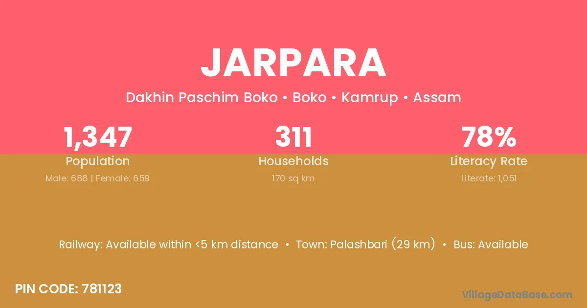
Jarpara village is located in the Boko Subdivision of the Kamrup district in Assam .
Block / Subdivision → Boko
District → Kamrup
State → Assam
According to Census 2011 information, the village code of Jarpara village is 781123.
Jarpara village has a total population of 1,347 people, of which 688 are males and 659 are females.
The literacy rate of Jarpara village is 78.03%. Male literacy stands at 81.69% and female literacy at 74.20%.
There are approximately 311 households in Jarpara village.
Palashbari (29 km) is the nearest town to Jarpara village for major economic activities and is located approximately 29 km away.
The population of Jarpara village is distributed between literate and illiterate residents as follows:
| Particulars | Male | Female | Total |
|---|---|---|---|
| Literate | 562 | 489 | 1,051 |
| Illiterate | 126 | 170 | 296 |
| Total | 688 | 659 | 1,347 |
Source: Census 2011
| Village | District |
|---|---|
| Chakabha | Kamrup |
| Dakhilipara | Kamrup |
| Khatkati | Kamrup |
| Langkona | Kamrup |
| Mouman | Kamrup |
| Nagopara | Kamrup |
| Nalaghat N C | Kamrup |
| Pakharapara | Kamrup |
| Raipara | Kamrup |
| Raipara | Dhamtari |
| Raipara | Raigarh |
| Tepchya | Kamrup |
| Tinigharia | Kamrup |
| Tinigharia | Cuttack |
| Tinigharia | Ganjam |
No reviews yet. Be the first to review this village!
Available within <5 km distance
Available within <5 km distance
Available within village