Goreswar: A Town and Subdivision in Kamrup district
District → Kamrup
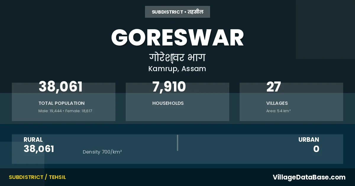
State → Assam
Goreswar is a town and Subdivision in the Kamrup district of the Assam. In India, a Subdivision is a subdivision of a district responsible for the administration and revenue collection of a specific area within the district. Subdivisions play a crucial role in the local governance structure, contributing significantly to the development and administration of their communities.
According to the 2011 census The total area of Goreswar Subdivision is 54 km², with a population of 38061 people. The population density is 700 inhabitants per square kilometre, and there are approximately 7910 houses in the sub district.
Goreswar Subdivision comprises about 27 villages. Below is a list of these villages along with information about their respective gram panchayats and the nearest town:
| # | Village Name | Gram Panchayat | Nearest Town |
|---|---|---|---|
| 1 | Balikuchi | Loch | Guwahati (31 km) |
| 2 | Bangal Gaon | Loch | Guwahati (30 km) |
| 3 | Bardangeri Kuchi | Bardangerikuchi | Guwahati (40 km) |
| 4 | Bargaon | Muktapur | Amingaon (20 km) |
| 5 | Barigaon | Loch | Guwahati (35 km) |
| 6 | Belkona | Muktapur | Guwahati (40 km) |
| 7 | Bhehbari | Bordol | Guwahati (45 km) |
| 8 | Dhulara | Bardangerikuchi | Guwahati (45 km) |
| 9 | Dhulura Lira | Loch | Guwahati (45 km) |
| 10 | Ganakjhar | Bardangerikuchi | Guwahati (45 km) |
| 11 | Gorka | Jatia Bangara | Guwahati (30 km) |
| 12 | Jaikuchi | Jatia Bangara | Guwahati (31 km) |
| 13 | Jatia Bhangra | Jatia Bangara | Guwahati (42 km) |
| 14 | Khepkuchi | Guwahati (45 km) | |
| 15 | Loch | Loch | Guwahati (30 km) |
| 16 | Mahajan Para | Bardangerikuchi | Guwahati (40 km) |
| 17 | Mahipal Kuchi | Loch | Guwahati (42 km) |
| 18 | Makundapur | Jatia Bangara | Guwahati (40 km) |
| 19 | Muktapur | Muktapur | Guwahati (27 km) |
| 20 | Na Satra | Loch | Guwahati (42 km) |
| 21 | Pubpar Jatia Bhangra | Jatia Bangara | Guwahati (30 km) |
| 22 | Pubpar Lokra | Bardangerikuchi | Guwahati (30 km) |
| 23 | Saledal | Muktapur | Guwahati (30 km) |
| 24 | Saulmari | Muktapur | Guwahati (30 km) |
| 25 | Sonari Sal | Loch | Guwahati (30 km) |
| 26 | Sutar Gaon | Loch | Guwahati (30 km) |
| 27 | Tulamali | Muktapur | Amingaon (20 km) |
The population is distributed between urban and rural areas as follows:
| Particulars | Rural | Urban | Total |
|---|---|---|---|
| Total Population | 38061 | 0 | 38061 |
| Male Population | 19444 | 0 | 19444 |
| Female Population | 18617 | 0 | 18617 | Population Density | 700 / km² | 700 / km² |
The distribution of households in the Goreswar is:
| Rural Households | Urban Households | Total Households |
|---|---|---|
| 7910 | 0 | 7910 |
Q: What is Goreswar?
A: Goreswar is a town and in the Kamrup district of the Assam.
Q: What is the total area of Goreswar Subdivision?
A: The total area of Goreswar Subdivision is 54 km².
Q: What is the population of Goreswar Subdivision according to the 2011 census?
A: According to the 2011 census, the population of Goreswar Subdivision is 38061.
Q: What is the population density of Goreswar Subdivision?
A: The population density of Goreswar Subdivision is 700 inhabitants per square kilometre.
Q: How many houses are there in Goreswar Subdivision?
A: There are approximately 7910 houses in Goreswar Subdivision.
Q: How many villages are there in Goreswar Subdivision?
A: There are about 27 villages in Goreswar Subdivision.
Q: Which is the largest village by population in Goreswar Subdivision?
A: The largest village by population in Goreswar Subdivision is Jatia Bhangra, with 3086 people.
Q: Which is the smallest village by population in Goreswar Subdivision?
A: The smallest village by population in Goreswar Subdivision is Barigaon, with 202 people.
Q: Which is the largest village by area in Goreswar Subdivision?
A: The largest village by area in Goreswar Subdivision is Jatia Bhangra, with 577 km².
Q: Which is the smallest village by area in Goreswar Subdivision?
A: The smallest village by area in Goreswar Subdivision is Barigaon, with 39 km².
Q: What is the population distribution between urban and rural areas in Goreswar Subdivision?
A: The population distribution in Goreswar Subdivision is entirely rural, with a total rural population of 38061.
Q: What is the male population of Goreswar Subdivision?
A: The male population of Goreswar Subdivision is 19444.
Q: What is the female population of Goreswar Subdivision?
A: The female population of Goreswar Subdivision is 18617.
Q: How is the household distribution in Goreswar Subdivision?
A: The household distribution in Goreswar Subdivision is entirely rural, with a total of 7910 households.
Q: How many villages in Goreswar Subdivision have a population between 100 and 499?
A: There are 1 villages in Goreswar Subdivision with a population between 100 and 499.
Q: How many villages in Goreswar Subdivision have a population between 500 and 999?
A: There are 11 villages in Goreswar Subdivision with a population between 500 and 999.
Q: How many villages in Goreswar Subdivision have a population between 1000 and 1999?
A: There are 8 villages in Goreswar Subdivision with a population between 1000 and 1999.
Q: How many villages in Goreswar Subdivision have a population between 2000 and 2999?
A: There is 6 village in Goreswar Subdivision with a population between 2000 and 2999.
Q: How many villages in Goreswar Subdivision have a population between 3000 and 3999?
A: There is 1 village in Goreswar Subdivision with a population between 3000 and 3999.
| Total Population | Villages in Sub District Of Goreswar |
|---|---|
| 100-499 | 1 |
| 500-999 | 11 |
| 1000-1999 | 8 |
| 2000-2999 | 6 |
| 3000-3999 | 1 |