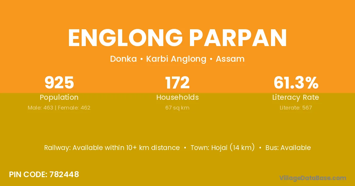
Englong Parpan village is located in the Donka Subdivision of the Karbi Anglong district in Assam .
Block / Subdivision → Donka
District → Karbi Anglong
State → Assam
According to Census 2011 information, the village code of Englong Parpan village is 782448.
Englong Parpan village has a total population of 925 people, of which 463 are males and 462 are females.
The literacy rate of Englong Parpan village is 61.30%. Male literacy stands at 67.60% and female literacy at 54.98%.
There are approximately 172 households in Englong Parpan village.
Hojai (14 km) is the nearest town to Englong Parpan village for major economic activities and is located approximately 14 km away.
The population of Englong Parpan village is distributed between literate and illiterate residents as follows:
| Particulars | Male | Female | Total |
|---|---|---|---|
| Literate | 313 | 254 | 567 |
| Illiterate | 150 | 208 | 358 |
| Total | 463 | 462 | 925 |
Source: Census 2011
| Village | District |
|---|---|
| Cheng Cheng Bil | Karbi Anglong |
| Chera Pathar | Karbi Anglong |
| Enchin Langso | Karbi Anglong |
| Engleng Gaon | Karbi Anglong |
| Engleng Gaon | Karbi Anglong |
| Lalmati | Bongaigaon |
| Lalmati | Karbi Anglong |
| Lalmati | Karbi Anglong |
| Lalmati | Kokrajhar |
| Lalmati | Janjgir Champa |
| Lalmati | Mahasamund |
| Lalmati | Surguja |
| Lalmati | Harda |
| Lalmati | Singrauli |
| Lalmati | Jalgaon |
| Lalmati | Ribhoi |
| Lalmati | West Garo Hills |
| Menmeji | Karbi Anglong |
| Mukhim | Karbi Anglong |
| Priloo | Karbi Anglong |
| Ramthepi | Karbi Anglong |
| Rongmandu | Karbi Anglong |
| Theso Bil | Karbi Anglong |
No reviews yet. Be the first to review this village!
Available within 10+ km distance
Available within village
Available within village