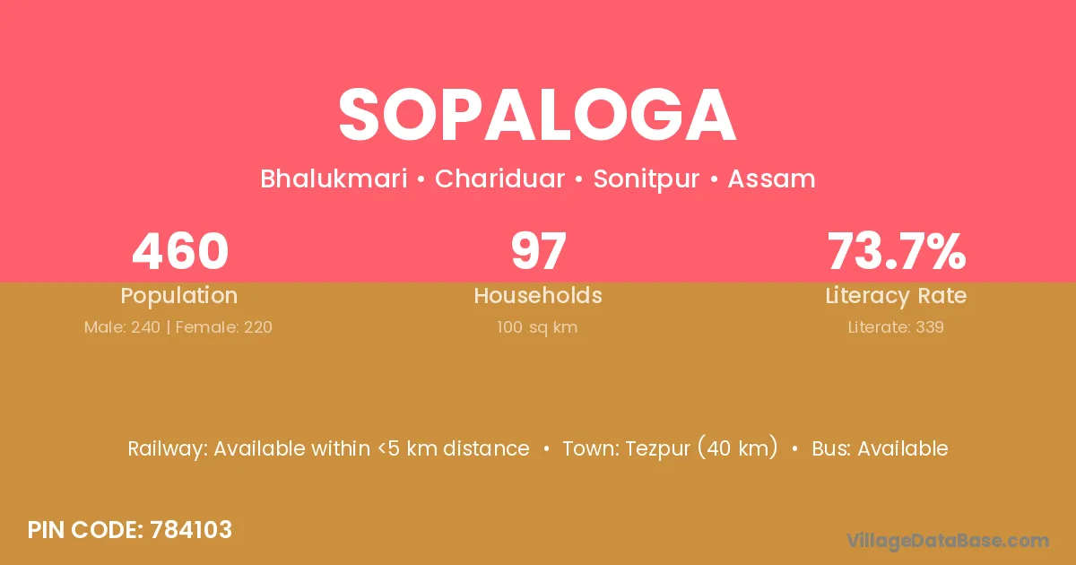
Sopaloga village is located in the Chariduar Subdivision of the Sonitpur district in Assam .
Block / Subdivision → Chariduar
District → Sonitpur
State → Assam
According to Census 2011 information, the village code of Sopaloga village is 784103.
Sopaloga village has a total population of 460 people, of which 240 are males and 220 are females.
The literacy rate of Sopaloga village is 73.70%. Male literacy stands at 81.67% and female literacy at 65.00%.
There are approximately 97 households in Sopaloga village.
Tezpur (40 km) is the nearest town to Sopaloga village for major economic activities and is located approximately 40 km away.
The population of Sopaloga village is distributed between literate and illiterate residents as follows:
| Particulars | Male | Female | Total |
|---|---|---|---|
| Literate | 196 | 143 | 339 |
| Illiterate | 44 | 77 | 121 |
| Total | 240 | 220 | 460 |
Source: Census 2011
| Village | District |
|---|---|
| Araliloga | Sonitpur |
| Bongijuli No 1 | Sonitpur |
| Dharikati | Sonitpur |
| Dopdopi | Sonitpur |
| Gamani Ban Gaon | Sonitpur |
| Gamari Loga | Sonitpur |
| Ganesh Pur | Sonitpur |
| Ganesh Pur | Farrukhabad |
| Ganesh Pur | Kheri |
| Ganesh Pur | Mahrajganj |
| Kachari Gaon Pambasti | Sonitpur |
| Satai Ban Gaon | Sonitpur |
| Tarajan | Dibrugarh |
| Tarajan | Karbi Anglong |
| Tarajan | Morigaon |
| Tarajan | Sonitpur |
| Tarajan | Sonitpur |
| Urohiloga Ban Gaon | Sonitpur |
No reviews yet. Be the first to review this village!
Available within <5 km distance
Available within 5 - 10 km distance
Available within 5 - 10 km distance