District → Darbhanga
State → Bihar
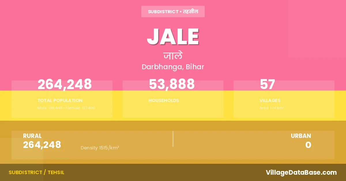
Jale is a town and Subdivision in the Darbhanga district of the Bihar. In India, a Subdivision is a subdivision of a district responsible for the administration and revenue collection of a specific area within the district. Subdivisions play a crucial role in the local governance structure, contributing significantly to the development and administration of their communities.
According to the 2011 census The total area of Jale Subdivision is 174 km², with a population of 264248 people. The population density is 1,515 inhabitants per square kilometre, and there are approximately 53888 houses in the sub district.
Jale Subdivision comprises about 57 villages. Below is a list of these villages along with information about their respective gram panchayats and the nearest town:
| # | Village Name | Gram Panchayat | Nearest Town |
|---|---|---|---|
| 1 | Ahiari | Ahiyari South | Darbhanga (34 km) |
| 2 | Badri | Sahaspur | Darbhanga (60 km) |
| 3 | Baghaul | Bandhouli | Darbhanga (38 km) |
| 4 | Bandhauli | Bandhouli | Darbhanga (41 km) |
| 5 | Barhampur | Brahmapur West | Darbhanga (40 km) |
| 6 | Chak Milki | Doghra | Darbhanga (50 km) |
| 7 | Chak Talaila | Dhadhiya | Darbhanga (25 km) |
| 8 | Chandar Dipa | Doghra | Darbhanga (55 km) |
| 9 | Chandauna | Sahaspur | Darbhanga (38 km) |
| 10 | Darhia | Dhadhiya | Darbhanga (25 km) |
| 11 | Deora | Bandhouli | Darbhanga (40 km) |
| 12 | Dighopatti | Bandhouli | Darbhanga (39 km) |
| 13 | Dighra | Doghra | Darbhanga (50 km) |
| 14 | Gadari | Jalley East | Dharbhanga (40 km) |
| 15 | Gaisri | Aihyari North | Darbhanga (25 km) |
| 16 | Ghograha | Sahaspur | Dharbhanga (38 km) |
| 17 | Harauli | Jalley North | Darbhanga (46 km) |
| 18 | Jale | Jale South | Dharbhanga (50 km) |
| 19 | Jogiara | Yogiara | Dharbhanga (37 km) |
| 20 | Kachhua | Kachhua | Darbhanga (34 km) |
| 21 | Kaji Bahera | Kazi Bahera | Darbhanga (40 km) |
| 22 | Kalwara | Ratanpur | Darbhanga (39 km) |
| 23 | Kamtaul | Kamtoul | Darbhanga (30 km) |
| 24 | Kangni | Kamtoul | Darbhanga (33 km) |
| 25 | Kardahuli | Karwa Tariyani | Darbhanga (36 km) |
| 26 | Karhans Ratanpur | Kachhua | Darbhanga (39 km) |
| 27 | Karwa | Karwa Tariyani | Darbhanga (40 km) |
| 28 | Katai | Barampur E | Darbhanga (50 km) |
| 29 | Kataia | Barampur E | Darbhanga (50 km) |
| 30 | Katraul | Katraul Basant | Darbhanga (43 km) |
| 31 | Khajurwara | Radai N | Darbhanga (32 km) |
| 32 | Kheraj | Sahaspur | Dharbhanga (39 km) |
| 33 | Lalpur | Rarhi West | Darbhanga (40 km) |
| 34 | Mahuli Nankar | Kazi Bahera | Darbhanga (25 km) |
| 35 | Majhaura | Massa | Darbhanga (35 km) |
| 36 | Malikpur | Kachhua | Darbhanga (35 km) |
| 37 | Manam Deb | Jalley North | Darbhanga (45 km) |
| 38 | Manamkhedu | Jalley North | Dharbhanga (47 km) |
| 39 | Massa | Massa | Darbhanga (30 km) |
| 40 | Milk Pauni | Jalley East | Darbhanga (39 km) |
| 41 | Muraitha | Muraitha | Darbhanga (35 km) |
| 42 | Nagar Diha | Kazi Bahera | Darbhanga (41 km) |
| 43 | Nawada | Yogiara | Dharbhanga (37 km) |
| 44 | Nimrauli | Ahiyari South | Darbhanga (36 km) |
| 45 | Pakhauli | Jalley East | Dharbhanga (40 km) |
| 46 | Pauni | Brahmapur West | Darbhanga (38 km) |
| 47 | Rajaun | Karwa Tariyani | Darbhanga (40 km) |
| 48 | Rajaun Asli | Karwa Tariyani | Darbhanga (42 km) |
| 49 | Rarhi | Radhi East | Darbhanga (40 km) |
| 50 | Ratanpur Abhiman | Ratanpur | Darbhanga (38 km) |
| 51 | Ratanpur Mokari | Ratanpur | Darbhanga (39 km) |
| 52 | Reorha | Reorha | Darbhanga (55 km) |
| 53 | Rumaul | Dhadhiya | Darbhanga (28 km) |
| 54 | Sadrabad | Jalley East | Darbhanga (40 km) |
| 55 | Sahaspur | Sahaspur | Dharbhanga (40 km) |
| 56 | Sisauni Rajaun | Karwa Tariyani | Darbhanga (42 km) |
| 57 | Tariani | Karwa Tariyani | Darbhanga (35 km) |
The population is distributed between urban and rural areas as follows:
| Particulars | Rural | Urban | Total |
|---|---|---|---|
| Total Population | 264248 | 0 | 264248 |
| Male Population | 136448 | 0 | 136448 |
| Female Population | 127800 | 0 | 127800 | Population Density | 1515 / km² | 1,515 / km² |
The distribution of households in the Jale is:
| Rural Households | Urban Households | Total Households |
|---|---|---|
| 53888 | 0 | 53888 |
Q: What is Jale?
A: Jale is a town and in the Darbhanga district of the Bihar.
Q: What is the total area of Jale Subdivision?
A: The total area of Jale Subdivision is 174 km².
Q: What is the population of Jale Subdivision according to the 2011 census?
A: According to the 2011 census, the population of Jale Subdivision is 264248.
Q: What is the population density of Jale Subdivision?
A: The population density of Jale Subdivision is 1,515 inhabitants per square kilometre.
Q: How many houses are there in Jale Subdivision?
A: There are approximately 53888 houses in Jale Subdivision.
Q: How many villages are there in Jale Subdivision?
A: There are about 57 villages in Jale Subdivision.
Q: Which is the largest village by population in Jale Subdivision?
A: The largest village by population in Jale Subdivision is Jale, with 37256 people.
Q: Which is the smallest village by population in Jale Subdivision?
A: The smallest village by population in Jale Subdivision is Kangni, with 39 people.
Q: Which is the largest village by area in Jale Subdivision?
A: The largest village by area in Jale Subdivision is Rarhi, with 2861 km².
Q: Which is the smallest village by area in Jale Subdivision?
A: The smallest village by area in Jale Subdivision is Sisauni Rajaun, with 5 km².
Q: What is the population distribution between urban and rural areas in Jale Subdivision?
A: The population distribution in Jale Subdivision is entirely rural, with a total rural population of 264248.
Q: What is the male population of Jale Subdivision?
A: The male population of Jale Subdivision is 136448.
Q: What is the female population of Jale Subdivision?
A: The female population of Jale Subdivision is 127800.
Q: How is the household distribution in Jale Subdivision?
A: The household distribution in Jale Subdivision is entirely rural, with a total of 53888 households.
Q: How many villages in Jale Subdivision have a population of less than 100?
A: There are 1 villages in Jale Subdivision with a population of less than 100.
Q: How many villages in Jale Subdivision have a population between 100 and 499?
A: There are 11 villages in Jale Subdivision with a population between 100 and 499.
Q: How many villages in Jale Subdivision have a population between 500 and 999?
A: There are 4 villages in Jale Subdivision with a population between 500 and 999.
Q: How many villages in Jale Subdivision have a population between 1000 and 1999?
A: There are 10 villages in Jale Subdivision with a population between 1000 and 1999.
Q: How many villages in Jale Subdivision have a population between 2000 and 2999?
A: There is 8 village in Jale Subdivision with a population between 2000 and 2999.
Q: How many villages in Jale Subdivision have a population between 3000 and 3999?
A: There is 5 village in Jale Subdivision with a population between 3000 and 3999.
Q: How many villages in Jale Subdivision have a population between 4000 and 4999?
A: There is 3 village in Jale Subdivision with a population between 4000 and 4999.
Q: How many villages in Jale Subdivision have a population of 5000 and above?
A: There is 15 village in Jale Subdivision with a population of 5000 and above.
| Total Population | Villages in Sub District Of Jale |
|---|---|
| Less than 100 | 1 |
| 100-499 | 11 |
| 500-999 | 4 |
| 1000-1999 | 10 |
| 2000-2999 | 8 |
| 3000-3999 | 5 |
| 4000-4999 | 3 |
| 5000 And Above | 15 |