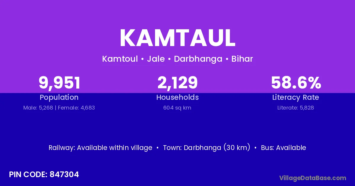
Kamtaul village is located in the Jale Subdivision of the Darbhanga district in Bihar .
Block / Subdivision → Jale
District → Darbhanga
State → Bihar
According to Census 2011 information, the village code of Kamtaul village is 847304.
Kamtaul village has a total population of 9,951 people, of which 5,268 are males and 4,683 are females.
The literacy rate of Kamtaul village is 58.57%. Male literacy stands at 65.47% and female literacy at 50.80%.
There are approximately 2,129 households in Kamtaul village.
Darbhanga (30 km) is the nearest town to Kamtaul village for major economic activities and is located approximately 30 km away.
The population of Kamtaul village is distributed between literate and illiterate residents as follows:
| Particulars | Male | Female | Total |
|---|---|---|---|
| Literate | 3,449 | 2,379 | 5,828 |
| Illiterate | 1,819 | 2,304 | 4,123 |
| Total | 5,268 | 4,683 | 9,951 |
Source: Census 2011
| Village | District |
|---|---|
| Chak Milki | Darbhanga |
| Chak Milki | Darbhanga |
| Chak Milki | Darbhanga |
| Chak Milki | Darbhanga |
| Chak Milki | Samastipur |
| Chak Milki | Samastipur |
| Chak Milki | Mirzapur |
| Chak Talaila | Darbhanga |
| Darhia | Darbhanga |
| Darhia | Pashchim Champaran |
| Darhia | Samastipur |
| Darhia | Azamgarh |
| Darhia | Basti |
| Darhia | Mirzapur |
| Darhia | Siddharthnagar |
| Gaisri | Darbhanga |
| Kangni | Darbhanga |
| Khajurwara | Darbhanga |
| Rajaun | Banka |
| Rajaun | Darbhanga |
| Rajaun | Jamui |
| Rajaun Asli | Darbhanga |
| Rarhi | Darbhanga |
| Rumaul | Darbhanga |
| Sisauni Rajaun | Darbhanga |
No reviews yet. Be the first to review this village!
Available within village
Available within 5 - 10 km distance
Available within village