Rupauli: A Town and Subdivision in Purnia district
District → Purnia
State → Bihar
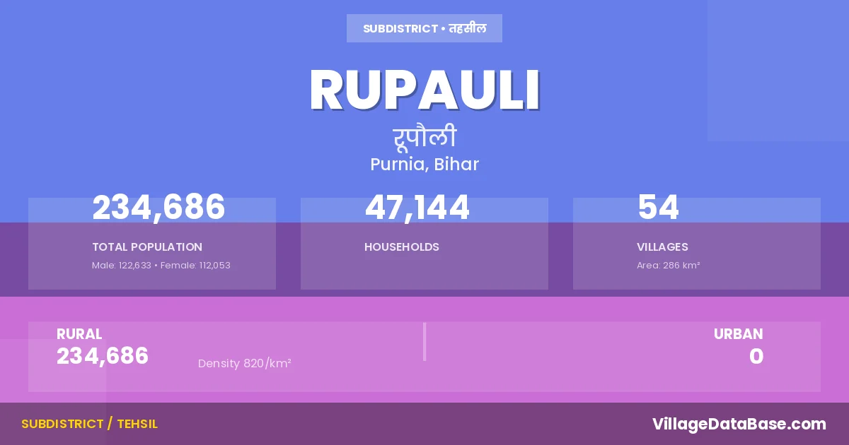
Rupauli is a town and Subdivision in the Purnia district of the Bihar. In India, a Subdivision is a subdivision of a district responsible for the administration and revenue collection of a specific area within the district. Subdivisions play a crucial role in the local governance structure, contributing significantly to the development and administration of their communities.
According to the 2011 census The total area of Rupauli Subdivision is 286 km², with a population of 234686 people. The population density is 820 inhabitants per square kilometre, and there are approximately 47144 houses in the sub district.
Rupauli Subdivision comprises about 54 villages. Below is a list of these villages along with information about their respective gram panchayats and the nearest town:
| # | Village Name | Gram Panchayat | Nearest Town |
|---|---|---|---|
| 1 | Anjhari | Bhauwa Parbal | Naugachhia (18 km) |
| 2 | Bahadura | Lachhmipur Girdhar | Purnia (65 km) |
| 3 | Bahuti | Nath Pur | Purnia (60 km) |
| 4 | Bairia | Goriarpatti Srimatta | Naugachhia (18 km) |
| 5 | Bairma | Bhauwa Parbal | Naugachhia (18 km) |
| 6 | Balia | Kanp | Naugachhia (12 km) |
| 7 | Banki | Bhikhana | Naugachhia (10 km) |
| 8 | Baradghatta | Ram Pur Parihat | Rupauli |
| 9 | Basantpur | Basant Pur | Purnia (48 km) |
| 10 | Basgarha | Basant Pur | Purnia (50 km) |
| 11 | Bela Parsadi | Bhikhana | Purnia (60 km) |
| 12 | Bharoria | Bhauwa Parbal | Rupauli |
| 13 | Bhartra Chakla | Goriarpatti Srimatta | Rupauli |
| 14 | Bhaua Parbal | Bhauwa Parbal | Purnia (60 km) |
| 15 | Bhawanipur Patkaili | Basant Pur | Purnia (65 km) |
| 16 | Bhelwa Badh | Singhpur Deera | Rupauli |
| 17 | Bhikna | Bhikhana | Purnia (64 km) |
| 18 | Bijai | Bhauwa Parbal | Naugachhia (6 km) |
| 19 | Bijaithana | Vijay Mohanpur | Rupauli |
| 20 | Chapahari | Basant Pur | Purnia (50 km) |
| 21 | Dhobgidha | Dhobgidha Rupauli | Purnia (60 km) |
| 22 | Dhobgidha Rupauli | Dhobgidha Rupauli | Purnia (60 km) |
| 23 | Dhusar | Laxmipur Charapatti | Naugachhia (25 km) |
| 24 | Dhusar Tikapatti | Dhusar Tikapatti | Naugachhia (25 km) |
| 25 | Dobha | Laxmipur Charapatti | Purnia (60 km) |
| 26 | Dobha Milik | Dobha Milik | Purnia (60 km) |
| 27 | Dumrail Chakla | Singhpur Deera | Rupauli |
| 28 | Goapara | Dobha Milik | Purnia (60 km) |
| 29 | Gonaili | Basant Pur | Rupauli |
| 30 | Goriar | Bijay Lal Ganj | Purnia (55 km) |
| 31 | Gurgawan | Nath Pur | Rupauli |
| 32 | Harnaha | Goriarpatti Srimatta | Purnia (60 km) |
| 33 | Imlakh | Laxmipur Charapatti | Naugachhia (25 km) |
| 34 | Kanp | Kanp | Naugachhia (13 km) |
| 35 | Khalsa Arazi | Vijay Mohanpur | Purnia (60 km) |
| 36 | Koili Semra | Bijay Lal Ganj | Purnia (50 km) |
| 37 | Lachhimipur Girdhar | Lachhmipur Girdhar | Purnia (68 km) |
| 38 | Lachhmipur | Laxmipur Charapatti | Purnia (58 km) |
| 39 | Mahabla | Dobha Milik | Purnia (60 km) |
| 40 | Maina Bhagwan Milik | Nath Pur | Purnia (60 km) |
| 41 | Maini | Ram Pur Parihat | Purnia (50 km) |
| 42 | Mataili Khemchand | Dhobgidha Rupauli | Purnia (58 km) |
| 43 | Mataili Khemnarain | Mataili Khemchandra | Purnia (58 km) |
| 44 | Mohanpur Istamrar | Vijay Mohanpur | Naugachhia (10 km) |
| 45 | Nathpur | Nath Pur | Purnia (60 km) |
| 46 | Nirpur Milik | Singhpur Deera | Rupauli |
| 47 | Pipra | Lachhmipur Girdhar | Purnia (60 km) |
| 48 | Pirraha | Goriar East | Purnia (55 km) |
| 49 | Rampur Parhat | Ram Pur Parihat | Purnia (54 km) |
| 50 | Sahgaura Milik | Singhpur Deera | Rupauli |
| 51 | Singhpur | Singhpur Deera | Purnia (60 km) |
| 52 | Sukhsena Milik | Singhpur Deera | Purnia (60 km) |
| 53 | Supaili Kamat | Ram Pur Parihat | Rupauli |
| 54 | Teldiha | Laxmipur Charapatti | Naugachhia (25 km) |
The population is distributed between urban and rural areas as follows:
| Particulars | Rural | Urban | Total |
|---|---|---|---|
| Total Population | 234686 | 0 | 234686 |
| Male Population | 122633 | 0 | 122633 |
| Female Population | 112053 | 0 | 112053 | Population Density | 820 / km² | 820 / km² |
The distribution of households in the Rupauli is:
| Rural Households | Urban Households | Total Households |
|---|---|---|
| 47144 | 0 | 47144 |
Q: What is Rupauli?
A: Rupauli is a town and in the Purnia district of the Bihar.
Q: What is the total area of Rupauli Subdivision?
A: The total area of Rupauli Subdivision is 286 km².
Q: What is the population of Rupauli Subdivision according to the 2011 census?
A: According to the 2011 census, the population of Rupauli Subdivision is 234686.
Q: What is the population density of Rupauli Subdivision?
A: The population density of Rupauli Subdivision is 820 inhabitants per square kilometre.
Q: How many houses are there in Rupauli Subdivision?
A: There are approximately 47144 houses in Rupauli Subdivision.
Q: How many villages are there in Rupauli Subdivision?
A: There are about 54 villages in Rupauli Subdivision.
Q: Which is the largest village by population in Rupauli Subdivision?
A: The largest village by population in Rupauli Subdivision is Goriar, with 26408 people.
Q: Which is the smallest village by population in Rupauli Subdivision?
A: The smallest village by population in Rupauli Subdivision is Baradghatta, with 0 people.
Q: Which is the largest village by area in Rupauli Subdivision?
A: The largest village by area in Rupauli Subdivision is Goriar, with 2690 km².
Q: Which is the smallest village by area in Rupauli Subdivision?
A: The smallest village by area in Rupauli Subdivision is Bhartra Chakla, with 8 km².
Q: What is the population distribution between urban and rural areas in Rupauli Subdivision?
A: The population distribution in Rupauli Subdivision is entirely rural, with a total rural population of 234686.
Q: What is the male population of Rupauli Subdivision?
A: The male population of Rupauli Subdivision is 122633.
Q: What is the female population of Rupauli Subdivision?
A: The female population of Rupauli Subdivision is 112053.
Q: How is the household distribution in Rupauli Subdivision?
A: The household distribution in Rupauli Subdivision is entirely rural, with a total of 47144 households.
Q: How many villages in Rupauli Subdivision have a population of less than 100?
A: There are 12 villages in Rupauli Subdivision with a population of less than 100.
Q: How many villages in Rupauli Subdivision have a population between 100 and 499?
A: There are 4 villages in Rupauli Subdivision with a population between 100 and 499.
Q: How many villages in Rupauli Subdivision have a population between 500 and 999?
A: There are 2 villages in Rupauli Subdivision with a population between 500 and 999.
Q: How many villages in Rupauli Subdivision have a population between 1000 and 1999?
A: There are 3 villages in Rupauli Subdivision with a population between 1000 and 1999.
Q: How many villages in Rupauli Subdivision have a population between 2000 and 2999?
A: There is 6 village in Rupauli Subdivision with a population between 2000 and 2999.
Q: How many villages in Rupauli Subdivision have a population between 3000 and 3999?
A: There is 6 village in Rupauli Subdivision with a population between 3000 and 3999.
Q: How many villages in Rupauli Subdivision have a population between 4000 and 4999?
A: There is 4 village in Rupauli Subdivision with a population between 4000 and 4999.
Q: How many villages in Rupauli Subdivision have a population of 5000 and above?
A: There is 17 village in Rupauli Subdivision with a population of 5000 and above.
| Total Population | Villages in Sub District Of Rupauli |
|---|---|
| Less than 100 | 12 |
| 100-499 | 4 |
| 500-999 | 2 |
| 1000-1999 | 3 |
| 2000-2999 | 6 |
| 3000-3999 | 6 |
| 4000-4999 | 4 |
| 5000 And Above | 17 |