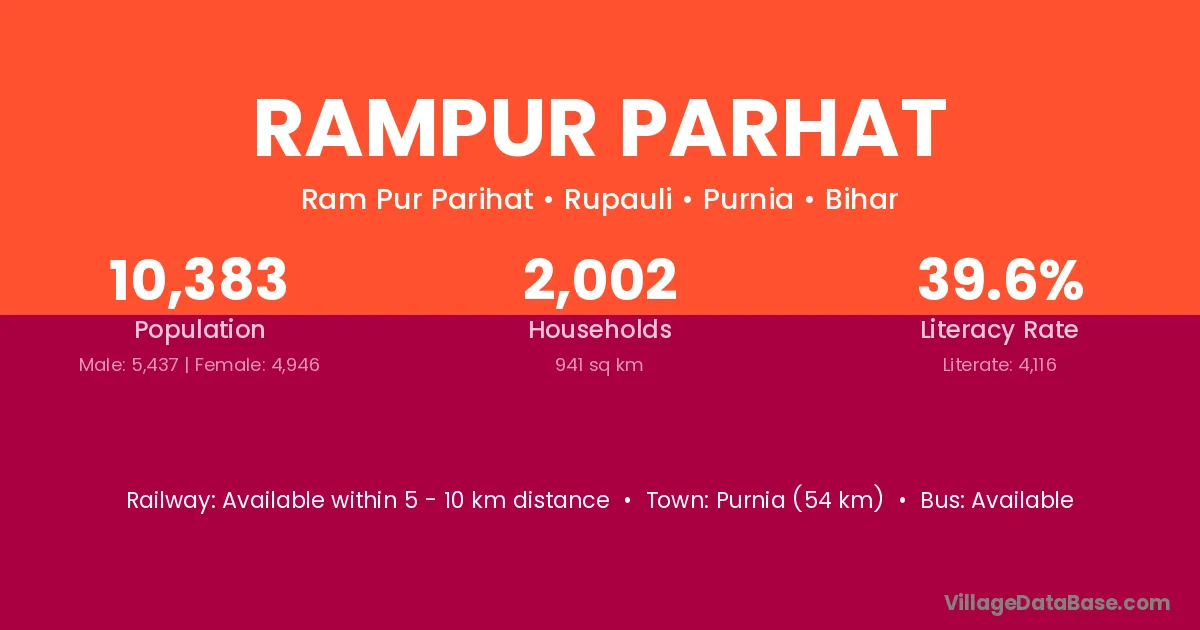
Rampur Parhat village is located in the Rupauli Subdivision of the Purnia district in Bihar .
Block / Subdivision → Rupauli
District → Purnia
State → Bihar
Rampur Parhat village has a total population of 10,383 people, of which 5,437 are males and 4,946 are females.
The literacy rate of Rampur Parhat village is 39.64%. Male literacy stands at 48.94% and female literacy at 29.42%.
There are approximately 2,002 households in Rampur Parhat village.
Purnia (54 km) is the nearest town to Rampur Parhat village for major economic activities and is located approximately 54 km away.
The population of Rampur Parhat village is distributed between literate and illiterate residents as follows:
| Particulars | Male | Female | Total |
|---|---|---|---|
| Literate | 2,661 | 1,455 | 4,116 |
| Illiterate | 2,776 | 3,491 | 6,267 |
| Total | 5,437 | 4,946 | 10,383 |
Source: Census 2011
| Village | District |
|---|---|
| Baradghatta | Purnia |
| Baradghatta | Purnia |
| Basgarha | Bhagalpur |
| Basgarha | Katihar |
| Basgarha | Purnia |
| Basgarha | Purnia |
| Bela Parsadi | Purnia |
| Bhelwa Badh | Purnia |
| Chapahari | Purnia |
| Goapara | Purnia |
| Gonaili | Munger |
| Gonaili | Purnia |
| Goriar | Purnia |
| Nathpur | Araria |
| Nathpur | Buxar |
| Nathpur | Purnia |
| Nathpur | Purnia |
| Nathpur | Siwan |
| Nathpur | Gumla |
| Nathpur | Gumla |
| Nathpur | Chhatarpur |
| Nathpur | Jajapur |
| Nathpur | Khordha |
| Nathpur | Gurdaspur |
| Nathpur | Aligarh |
| Nathpur | Azamgarh |
| Nathpur | Basti |
| Nathpur | Gonda |
| Nathpur | Kanshiram Nagar |
| Nathpur | Varanasi |
| Nathpur | Barddhaman |
| Nathpur | Nadia |
| Nathpur | Nadia |
| Sahgaura Milik | Purnia |
| Sahgaura Milik | Purnia |
| Sukhsena Milik | Purnia |
| Sukhsena Milik | Purnia |
| Sukhsena Milik | Purnia |
No reviews yet. Be the first to review this village!
Available within 5 - 10 km distance
Available within 5 - 10 km distance
Available within village