District → Rohtas
State → Bihar
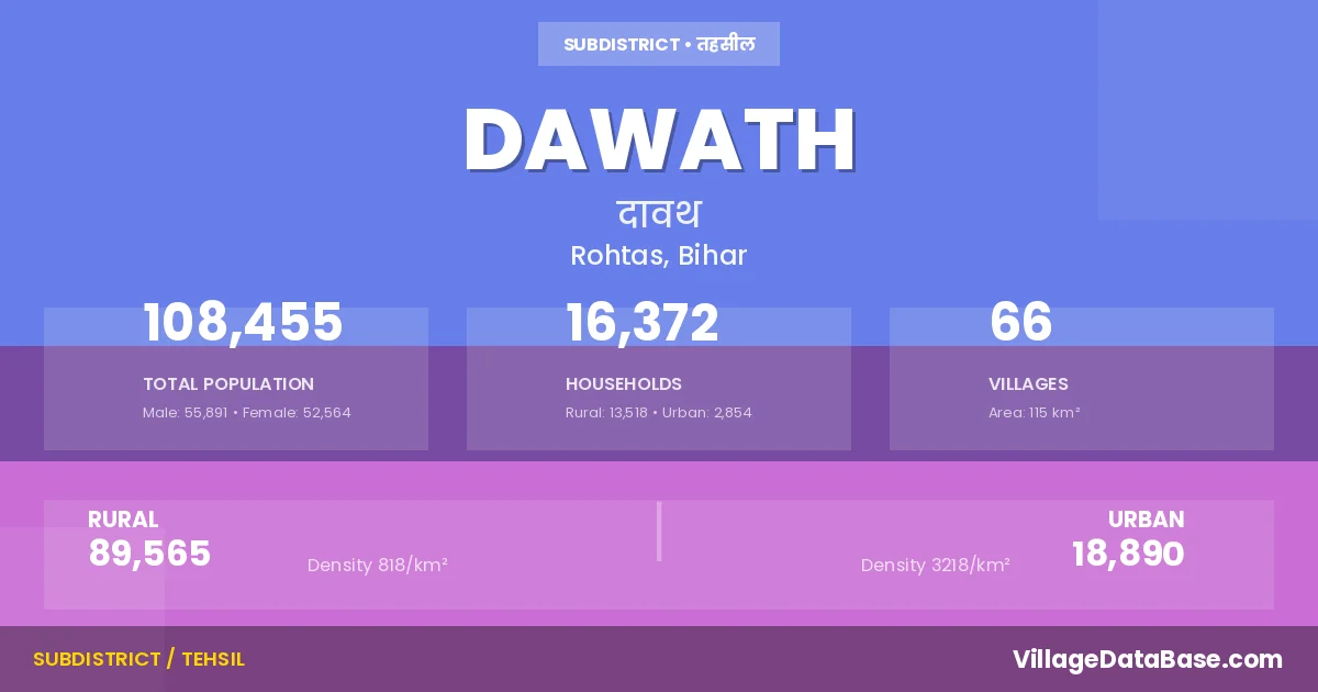
Dawath is a town and Subdivision in the Rohtas district of the Bihar. In India, a Subdivision is a subdivision of a district responsible for the administration and revenue collection of a specific area within the district. Subdivisions play a crucial role in the local governance structure, contributing significantly to the development and administration of their communities.
According to the 2011 census The total area of Dawath Subdivision is 115 km², with a population of 108455 people. The population density is 940 inhabitants per square kilometre, and there are approximately 16372 houses in the sub district.
Dawath Subdivision comprises about 66 villages. Below is a list of these villages along with information about their respective gram panchayats and the nearest town:
| # | Village Name | Gram Panchayat | Nearest Town |
|---|---|---|---|
| 1 | Ahir Chaunri | Usari | Koath (4 km) |
| 2 | Akorha | Jamsona | Koath (10 km) |
| 3 | Anwarhi | Jamsona | Koath (11 km) |
| 4 | Babhanaul | Babhnaul | Koath (7 km) |
| 5 | Babhani | Itwan | Koath (5 km) |
| 6 | Bahuara | Itwan | Koath (6 km) |
| 7 | Bairia | Sahi Naun | Koath (10 km) |
| 8 | Bairiya | Itwan | Koath (5 km) |
| 9 | Batsa | Itwan | Koath (8 km) |
| 10 | Bhatauli | Gidha | Koath (12 km) |
| 11 | Bhundadih | Usari | Koath (6 km) |
| 12 | Bithni | Sahi Naun | Koath (10 km) |
| 13 | Bithwa | Dawath | Koath (8 km) |
| 14 | Bodarhi | Dawath | Koath (10 km) |
| 15 | Bodh Chatar | Gidha | Koath (9 km) |
| 16 | Chak Chatar | Gidha | Koath (12 km) |
| 17 | Chatra | Sahi Naun | Koath (10 km) |
| 18 | Chaunri Kedar | Usari | Koath (4 km) |
| 19 | Chhitni | Sahi Naun | Koath (14 km) |
| 20 | Choranti | Sahi Naun | Koath (10 km) |
| 21 | Damdiha | Jamsona | Koath (10 km) |
| 22 | Dawath | Dawath | Koath (8 km) |
| 23 | Derhgaon | Dergaun | Koath (3 km) |
| 24 | Dewgana | Usari | Koath (7 km) |
| 25 | Dewrhi | Sahi Naun | Koath (10 km) |
| 26 | Dharkanha Kalan | Jamsona | Koath (10 km) |
| 27 | Dharkanha Khurd | Jamsona | Koath (10 km) |
| 28 | Dolaicha | Usari | Koath (7 km) |
| 29 | Doma Dehri | Sahi Naun | Koath (10 km) |
| 30 | Gidha | Gidha | Koath (6 km) |
| 31 | Gopal Dehri | Gidha | Koath (13 km) |
| 32 | Hamir Dehri | Itwan | Koath (4 km) |
| 33 | Harakhmal Dehri | Jamsona | Koath (12 km) |
| 34 | Harna Chatar | Gidha | Koath (8 km) |
| 35 | Hathdihan | Gidha | Koath (16 km) |
| 36 | Itwa | Itwan | Koath (5 km) |
| 37 | Jagadhara | Itwan | Koath (4 km) |
| 38 | Jamsona | Jamsona | Koath (10 km) |
| 39 | Jharkharia | Itwan | Koath (4 km) |
| 40 | Kamdhanwan | Sahi Naun | Koath (11 km) |
| 41 | Katailbal | Dergaun | Koath (12 km) |
| 42 | Khairahi | Itwan | Koath (6 km) |
| 43 | Kharanti | Sahi Naun | Dawath |
| 44 | Madhopur | Gidha | Koath (14 km) |
| 45 | Madhubana | Usari | Dawath |
| 46 | Mahuari | Sahi Naun | Koath (10 km) |
| 47 | Naktauli | Gidha | Koath (13 km) |
| 48 | Narayanpur | Jamsona | Dawath |
| 49 | Param Dehri | Itwan | Koath (8 km) |
| 50 | Pararia | Sahi Naun | Koath (12 km) |
| 51 | Parmanpur | Gidha | Koath (15 km) |
| 52 | Parsiya Kalen | Semari | Koath (8 km) |
| 53 | Parsiyakhurd | Semari | Koath (8 km) |
| 54 | Pasram Patti Dalia | Dawath | Dawath |
| 55 | Patkhauli | Jamsona | Koath (11 km) |
| 56 | Rajaundha | Sahi Naun | Koath (10 km) |
| 57 | Ramnagar | Dergaun | Koath (13 km) |
| 58 | Saadat Dehra | Dawath | Koath (4 km) |
| 59 | Sahinaon | Sahi Naun | Koath (10 km) |
| 60 | Semri | Semari | Koath (8 km) |
| 61 | Shahpur | Itwan | Koath (8 km) |
| 62 | Sughari | Dawath | Dawath |
| 63 | Sundar | Usari | Koath (5 km) |
| 64 | Tendobahar | Itwan | Dawath |
| 65 | Tilakpura | Dergaun | Koath (11 km) |
| 66 | Usari | Usari | Koath (4 km) |
The population is distributed between urban and rural areas as follows:
| Particulars | Rural | Urban | Total |
|---|---|---|---|
| Total Population | 89565 | 18890 | 108455 |
| Male Population | 46076 | 9815 | 55891 |
| Female Population | 43489 | 9075 | 52564 | Population Density | 818 / km² | 3218 / km² | 940 / km² |
The distribution of households in the Dawath is:
| Rural Households | Urban Households | Total Households |
|---|---|---|
| 13518 | 2854 | 16372 |
Q: What is Dawath?
A: Dawath is a town and in the Rohtas district of the Bihar.
Q: What is the total area of Dawath Subdivision?
A: The total area of Dawath Subdivision is 115 km².
Q: What is the population of Dawath Subdivision according to the 2011 census?
A: According to the 2011 census, the population of Dawath Subdivision is 108455.
Q: What is the population density of Dawath Subdivision?
A: The population density of Dawath Subdivision is 940 inhabitants per square kilometre.
Q: How many houses are there in Dawath Subdivision?
A: There are approximately 16372 houses in Dawath Subdivision.
Q: How many villages are there in Dawath Subdivision?
A: There are about 66 villages in Dawath Subdivision.
Q: Which is the largest village by population in Dawath Subdivision?
A: The largest village by population in Dawath Subdivision is Semri, with 11204 people.
Q: Which is the smallest village by population in Dawath Subdivision?
A: The smallest village by population in Dawath Subdivision is Kharanti, with 0 people.
Q: Which is the largest village by area in Dawath Subdivision?
A: The largest village by area in Dawath Subdivision is Babhanaul, with 957 km².
Q: Which is the smallest village by area in Dawath Subdivision?
A: The smallest village by area in Dawath Subdivision is Babhani, with 0 km².
Q: What is the male population of Dawath Subdivision?
A: The male population of Dawath Subdivision is 55891.
Q: What is the female population of Dawath Subdivision?
A: The female population of Dawath Subdivision is 52564.
Q: How many villages in Dawath Subdivision have a population of less than 100?
A: There are 7 villages in Dawath Subdivision with a population of less than 100.
Q: How many villages in Dawath Subdivision have a population between 100 and 499?
A: There are 13 villages in Dawath Subdivision with a population between 100 and 499.
Q: How many villages in Dawath Subdivision have a population between 500 and 999?
A: There are 18 villages in Dawath Subdivision with a population between 500 and 999.
Q: How many villages in Dawath Subdivision have a population between 1000 and 1999?
A: There are 17 villages in Dawath Subdivision with a population between 1000 and 1999.
Q: How many villages in Dawath Subdivision have a population between 2000 and 2999?
A: There is 7 village in Dawath Subdivision with a population between 2000 and 2999.
Q: How many villages in Dawath Subdivision have a population between 4000 and 4999?
A: There is 1 village in Dawath Subdivision with a population between 4000 and 4999.
Q: How many villages in Dawath Subdivision have a population of 5000 and above?
A: There is 3 village in Dawath Subdivision with a population of 5000 and above.
| Total Population | Villages in Sub District Of Dawath |
|---|---|
| Less than 100 | 7 |
| 100-499 | 13 |
| 500-999 | 18 |
| 1000-1999 | 17 |
| 2000-2999 | 7 |
| 4000-4999 | 1 |
| 5000 And Above | 3 |