Tilouthu: A Town and Subdivision in Rohtas district
District → Rohtas
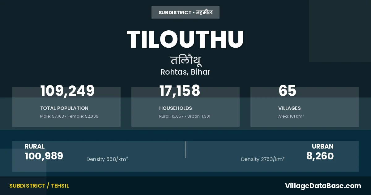
State → Bihar
Tilouthu is a town and Subdivision in the Rohtas district of the Bihar. In India, a Subdivision is a subdivision of a district responsible for the administration and revenue collection of a specific area within the district. Subdivisions play a crucial role in the local governance structure, contributing significantly to the development and administration of their communities.
According to the 2011 census The total area of Tilouthu Subdivision is 181 km², with a population of 109249 people. The population density is 604 inhabitants per square kilometre, and there are approximately 17158 houses in the sub district.
Tilouthu Subdivision comprises about 65 villages. Below is a list of these villages along with information about their respective gram panchayats and the nearest town:
| # | Village Name | Gram Panchayat | Nearest Town |
|---|---|---|---|
| 1 | Alinagar | Tilouthu West | Dehri (16 km) |
| 2 | Amra | Kerpa | Dehri (17 km) |
| 3 | Bahera | Chandanpura | Sasaram (25 km) |
| 4 | Baradih | Inderpuri | Dehri (17 km) |
| 5 | Bardiha | Sewahi | Sasaram (19 km) |
| 6 | Basdiha | Kerpa | Dehri (14 km) |
| 7 | Baulia | Ramdihra | Sasaram (21 km) |
| 8 | Belwai | Bhadokhra | Tilouthu |
| 9 | Bhadokhra | Bhadokhra | Dehri (20 km) |
| 10 | Bhadsa | Chitauli | Sasaram (22 km) |
| 11 | Bharkhoha | Sewahi | Sasaram (22 km) |
| 12 | Bhisra | Kerpa | Sasaram (20 km) |
| 13 | Bishunpura | Chitauli | Sasaram (25 km) |
| 14 | Chanpura | Chandanpura | Sasaram (24 km) |
| 15 | Chemni Chak | Sewahi | Tilouthu |
| 16 | Chitauli | Chitauli | Sasaram (26 km) |
| 17 | Chorkap | Chandanpura | Sasaram (23 km) |
| 18 | Churesar | Ramdihra | Sasaram (22 km) |
| 19 | Dattauli | Hurka | Sasaram (16 km) |
| 20 | Dehri | Hurka | Sasaram (18 km) |
| 21 | Dharampur | Tilouthu West | Tilouthu |
| 22 | Dighi | Bhadokhra | Tilouthu |
| 23 | Dubauli | Hurka | Sasaram (21 km) |
| 24 | Harnachiti | Tilouthu West | Dehri (18 km) |
| 25 | Hurka | Hurka | Sasaram (18 km) |
| 26 | Indarpura | Inderpuri | Sasaram (18 km) |
| 27 | Jago Dih | Ramdihra | Sasaram (22 km) |
| 28 | Jainagra | Inderpuri | Dehri (14 km) |
| 29 | Jamuhara | Inderpuri | Sasaram (18 km) |
| 30 | Jaraha | Inderpuri | Dehri (13 km) |
| 31 | Jhajhara | Bhadokhra | Tilouthu |
| 32 | Kaithi | Bhadokhra | Dehri (21 km) |
| 33 | Kerpa | Kerpa | Dehri (20 km) |
| 34 | Koidih | Hurka | Sasaram (15 km) |
| 35 | Kusdihra | Hurka | Sasaram (20 km) |
| 36 | Lewara | Hurka | Sasaram (12 km) |
| 37 | Madhanian | Inderpuri | Dehri (14 km) |
| 38 | Maheshdih | Hurka | Sasaram (22 km) |
| 39 | Malpura | Chandanpura | Sasaram (24 km) |
| 40 | Margohi | Bhadokhra | Sasaram (21 km) |
| 41 | Mira Sarae | Inderpuri | Dehri (15 km) |
| 42 | Mirzapur | Sewahi | Sasaram (20 km) |
| 43 | Mitarsenpur | Sewahi | Sasaram (22 km) |
| 44 | Panraria | Chitauli | Sasaram (22 km) |
| 45 | Panti | Ramdihra | Tilouthu |
| 46 | Pathara | Tilouthu West | Dehri (18 km) |
| 47 | Patluka | Sewahi | Sasaram (21 km) |
| 48 | Pirna Bigha | Chitauli | Sasaram (38 km) |
| 49 | Rakian Bigha | Sariaya | Sasaram (25 km) |
| 50 | Ramdihra | Ramdihra | Sasaram (19 km) |
| 51 | Rampur | Ramdihra | Tilouthu |
| 52 | Ranjit Ganj | Chitauli | Sasaram (28 km) |
| 53 | Renria | Chandanpura | Sasaram (31 km) |
| 54 | Rupahtha | Ramdihra | Sasaram (22 km) |
| 55 | Saina | Bhadokhra | Dehri (22 km) |
| 56 | Saraiya | Sariaya | Tilouthu |
| 57 | Seua | Inderpuri | Dehri (17 km) |
| 58 | Sewahi | Sewahi | Sasaram (20 km) |
| 59 | Shiupur | Bhadokhra | Dehri (22 km) |
| 60 | Sonaura | Tilouthu West | Dehri (18 km) |
| 61 | Sonpura | Chandanpura | Sasaram (24 km) |
| 62 | Supa Sarae | Chitauli | Sasaram (22 km) |
| 63 | Tilauthu | Tilouthu East | Dehri (14 km) |
| 64 | Tilauthu Arazi | Tilouthu West | Tilouthu |
| 65 | Uchaila | Kerpa | Dehri (24 km) |
The population is distributed between urban and rural areas as follows:
| Particulars | Rural | Urban | Total |
|---|---|---|---|
| Total Population | 100989 | 8260 | 109249 |
| Male Population | 52780 | 4383 | 57163 |
| Female Population | 48209 | 3877 | 52086 | Population Density | 568 / km² | 2763 / km² | 604 / km² |
The distribution of households in the Tilouthu is:
| Rural Households | Urban Households | Total Households |
|---|---|---|
| 15857 | 1301 | 17158 |
Q: What is Tilouthu?
A: Tilouthu is a town and in the Rohtas district of the Bihar.
Q: What is the total area of Tilouthu Subdivision?
A: The total area of Tilouthu Subdivision is 181 km².
Q: What is the population of Tilouthu Subdivision according to the 2011 census?
A: According to the 2011 census, the population of Tilouthu Subdivision is 109249.
Q: What is the population density of Tilouthu Subdivision?
A: The population density of Tilouthu Subdivision is 604 inhabitants per square kilometre.
Q: How many houses are there in Tilouthu Subdivision?
A: There are approximately 17158 houses in Tilouthu Subdivision.
Q: How many villages are there in Tilouthu Subdivision?
A: There are about 65 villages in Tilouthu Subdivision.
Q: Which is the largest village by population in Tilouthu Subdivision?
A: The largest village by population in Tilouthu Subdivision is Tilauthu, with 16402 people.
Q: Which is the smallest village by population in Tilouthu Subdivision?
A: The smallest village by population in Tilouthu Subdivision is Belwai, with 0 people.
Q: Which is the largest village by area in Tilouthu Subdivision?
A: The largest village by area in Tilouthu Subdivision is Churesar, with 1627 km².
Q: Which is the smallest village by area in Tilouthu Subdivision?
A: The smallest village by area in Tilouthu Subdivision is Saraiya, with 0 km².
Q: What is the male population of Tilouthu Subdivision?
A: The male population of Tilouthu Subdivision is 57163.
Q: What is the female population of Tilouthu Subdivision?
A: The female population of Tilouthu Subdivision is 52086.
Q: How many villages in Tilouthu Subdivision have a population of less than 100?
A: There are 11 villages in Tilouthu Subdivision with a population of less than 100.
Q: How many villages in Tilouthu Subdivision have a population between 100 and 499?
A: There are 8 villages in Tilouthu Subdivision with a population between 100 and 499.
Q: How many villages in Tilouthu Subdivision have a population between 500 and 999?
A: There are 9 villages in Tilouthu Subdivision with a population between 500 and 999.
Q: How many villages in Tilouthu Subdivision have a population between 1000 and 1999?
A: There are 25 villages in Tilouthu Subdivision with a population between 1000 and 1999.
Q: How many villages in Tilouthu Subdivision have a population between 2000 and 2999?
A: There is 5 village in Tilouthu Subdivision with a population between 2000 and 2999.
Q: How many villages in Tilouthu Subdivision have a population between 3000 and 3999?
A: There is 3 village in Tilouthu Subdivision with a population between 3000 and 3999.
Q: How many villages in Tilouthu Subdivision have a population between 4000 and 4999?
A: There is 3 village in Tilouthu Subdivision with a population between 4000 and 4999.
Q: How many villages in Tilouthu Subdivision have a population of 5000 and above?
A: There is 1 village in Tilouthu Subdivision with a population of 5000 and above.
| Total Population | Villages in Sub District Of Tilouthu |
|---|---|
| Less than 100 | 11 |
| 100-499 | 8 |
| 500-999 | 9 |
| 1000-1999 | 25 |
| 2000-2999 | 5 |
| 3000-3999 | 3 |
| 4000-4999 | 3 |
| 5000 And Above | 1 |