District → Dohad
State → Gujarat
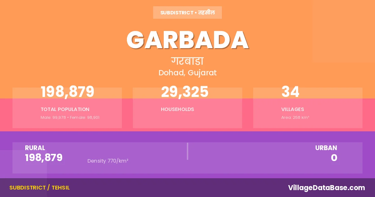
Garbada is a town and Taluka in the Dohad district of the Gujarat. In India, a Taluka is a subdivision of a district responsible for the administration and revenue collection of a specific area within the district. Talukas play a crucial role in the local governance structure, contributing significantly to the development and administration of their communities.
According to the 2011 census The total area of Garbada Taluka is 258 km², with a population of 198879 people. The population density is 770 inhabitants per square kilometre, and there are approximately 29325 houses in the sub district.
Garbada Taluka comprises about 34 villages. Below is a list of these villages along with information about their respective gram panchayats and the nearest town:
| # | Village Name | Gram Panchayat | Nearest Town |
|---|---|---|---|
| 1 | Abhlod | Abhlod | Dohad (10 km) |
| 2 | Ambli | Ambli | Dohad (14 km) |
| 3 | Bharsada | Bharsada | Dohad (24 km) |
| 4 | Bhe | Bhe | Dohad (25 km) |
| 5 | Bhutardi | Bhutardi | Dohad (22 km) |
| 6 | Boriyala | Boriyala | Dohad (16 km) |
| 7 | Chandla | Chandla | Dohad (22 km) |
| 8 | Chharchhoda | Chharchhoda | Dohad (18 km) |
| 9 | Dadur | Dadur | Dohad (30 km) |
| 10 | Devdha | Devdha | Dohad (11 km) |
| 11 | Gangarda | Gangarda | Dohad (14 km) |
| 12 | Gangardi | Gangardi | Dohad (24 km) |
| 13 | Garbada | Bhiloi Garbada | Dohad (19 km) |
| 14 | Gulbar | Gulbar | Dohad (30 km) |
| 15 | Jambua | Jambua | Dohad (26 km) |
| 16 | Jesawada | Jesawada | Dohad (14 km) |
| 17 | Matwa | Matwa | Dohad (10 km) |
| 18 | Minakyar | Minakyar | Dohad (22 km) |
| 19 | Nadhelav | Nadhelav | Dohad (16 km) |
| 20 | Nalwai | Nalwai | Dohad (21 km) |
| 21 | Nandva | Nandva | Dohad (24 km) |
| 22 | Nelsur | Nelsur | Dohad (14 km) |
| 23 | Nimach | Nimach | Dohad (26 km) |
| 24 | Panchwada | Panchwada | Dohad (11 km) |
| 25 | Pandadi | Pandadi | Dohad (15 km) |
| 26 | Patiya | Patiya | Dohad (33 km) |
| 27 | Patiya Zol | Bhutardi | Dohad (22 km) |
| 28 | Sahada | Sahada | Dohad (11 km) |
| 29 | Simaliya Bujarg | Simaliya Bujarg | Dohad (16 km) |
| 30 | Tunki Anop | Tunki Vaju | Dohad (11 km) |
| 31 | Tunki Vaju | Tunki Vaju | Dohad (21 km) |
| 32 | Vadva | Vadva | Dohad (14 km) |
| 33 | Vajelav | Vajelav | Dohad (18 km) |
| 34 | Zari Bujarg | Zari Bujarg | Dohad (24 km) |
The population is distributed between urban and rural areas as follows:
| Particulars | Rural | Urban | Total |
|---|---|---|---|
| Total Population | 198879 | 0 | 198879 |
| Male Population | 99978 | 0 | 99978 |
| Female Population | 98901 | 0 | 98901 | Population Density | 770 / km² | 770 / km² |
The distribution of households in the Garbada is:
| Rural Households | Urban Households | Total Households |
|---|---|---|
| 29325 | 0 | 29325 |
Q: What is Garbada?
A: Garbada is a town and in the Dohad district of the Gujarat.
Q: What is the total area of Garbada Taluka?
A: The total area of Garbada Taluka is 258 km².
Q: What is the population of Garbada Taluka according to the 2011 census?
A: According to the 2011 census, the population of Garbada Taluka is 198879.
Q: What is the population density of Garbada Taluka?
A: The population density of Garbada Taluka is 770 inhabitants per square kilometre.
Q: How many houses are there in Garbada Taluka?
A: There are approximately 29325 houses in Garbada Taluka.
Q: How many villages are there in Garbada Taluka?
A: There are about 34 villages in Garbada Taluka.
Q: Which is the largest village by population in Garbada Taluka?
A: The largest village by population in Garbada Taluka is Garbada, with 22691 people.
Q: Which is the smallest village by population in Garbada Taluka?
A: The smallest village by population in Garbada Taluka is Bhutardi, with 1155 people.
Q: Which is the largest village by area in Garbada Taluka?
A: The largest village by area in Garbada Taluka is Zari Bujarg, with 2702 km².
Q: Which is the smallest village by area in Garbada Taluka?
A: The smallest village by area in Garbada Taluka is Bhutardi, with 144 km².
Q: What is the population distribution between urban and rural areas in Garbada Taluka?
A: The population distribution in Garbada Taluka is entirely rural, with a total rural population of 198879.
Q: What is the male population of Garbada Taluka?
A: The male population of Garbada Taluka is 99978.
Q: What is the female population of Garbada Taluka?
A: The female population of Garbada Taluka is 98901.
Q: How is the household distribution in Garbada Taluka?
A: The household distribution in Garbada Taluka is entirely rural, with a total of 29325 households.
Q: How many villages in Garbada Taluka have a population between 1000 and 1999?
A: There are 4 villages in Garbada Taluka with a population between 1000 and 1999.
Q: How many villages in Garbada Taluka have a population between 2000 and 2999?
A: There is 4 village in Garbada Taluka with a population between 2000 and 2999.
Q: How many villages in Garbada Taluka have a population between 3000 and 3999?
A: There is 5 village in Garbada Taluka with a population between 3000 and 3999.
Q: How many villages in Garbada Taluka have a population between 4000 and 4999?
A: There is 5 village in Garbada Taluka with a population between 4000 and 4999.
Q: How many villages in Garbada Taluka have a population of 5000 and above?
A: There is 16 village in Garbada Taluka with a population of 5000 and above.
| Total Population | Villages in Sub District Of Garbada |
|---|---|
| 1000-1999 | 4 |
| 2000-2999 | 4 |
| 3000-3999 | 5 |
| 4000-4999 | 5 |
| 5000 And Above | 16 |