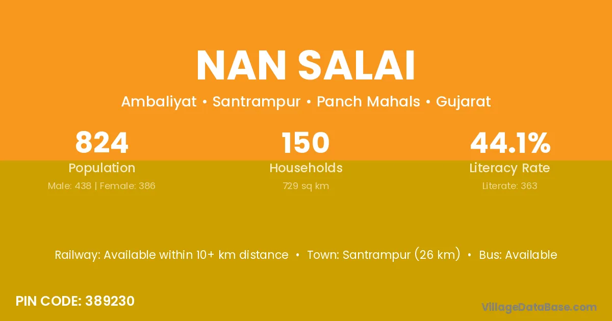
Nan Salai village is located in the Santrampur Taluka of the Panch Mahals district in Gujarat .
Block / Taluka → Santrampur
District → Panch Mahals
State → Gujarat
According to Census 2011 information, the village code of Nan Salai village is 389230.
Nan Salai village has a total population of 824 people, of which 438 are males and 386 are females.
The literacy rate of Nan Salai village is 44.05%. Male literacy stands at 54.34% and female literacy at 32.38%.
There are approximately 150 households in Nan Salai village.
Santrampur (26 km) is the nearest town to Nan Salai village for major economic activities and is located approximately 26 km away.
The population of Nan Salai village is distributed between literate and illiterate residents as follows:
| Particulars | Male | Female | Total |
|---|---|---|---|
| Literate | 238 | 125 | 363 |
| Illiterate | 200 | 261 | 461 |
| Total | 438 | 386 | 824 |
Source: Census 2011
| Village | District |
|---|---|
| Anjanwa | Panch Mahals |
| Charada | Gandhinagar |
| Charada | Panch Mahals |
| Charada | Baudh |
| Charada | Jajapur |
| Charada | Koraput |
| Falwa | Panch Mahals |
| Kenpur | Panch Mahals |
| Kenpur | Sabar Kantha |
| Khodadra | Panch Mahals |
| Panchmuva | Panch Mahals |
| Rambhemna Muvada | Panch Mahals |
| Singalgadh | Panch Mahals |
| Vaghfal | Panch Mahals |
| Vandariya | Bharuch |
| Vandariya | Dohad |
| Vandariya | Panch Mahals |
| Vankdi | Panch Mahals |
No reviews yet. Be the first to review this village!
Available within 10+ km distance
Available within village
Available within 10+ km distance