Welcome Back

Forgot password?
Don't have an account?
🏘️ Menu
Surendranagar District 0.0 / 5 (0)

Zampodad Village Detailed Information

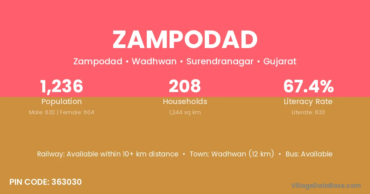
Zampodad village is located in the Wadhwan Taluka of the Surendranagar district in Gujarat .

Zampodad

About Zampodad Village

Block / Taluka → Wadhwan

District → Surendranagar

State → Gujarat

According to Census 2011 information, the village code of Zampodad village is 363030.

Zampodad village has a total population of 1,236 people, of which 632 are males and 604 are females.

The literacy rate of Zampodad village is 67.39%. Male literacy stands at 77.37% and female literacy at 56.95%.

There are approximately 208 households in Zampodad village.

Wadhwan (12 km) is the nearest town to Zampodad village for major economic activities and is located approximately 12 km away.

Population of Zampodad Village

The population of Zampodad village is distributed between literate and illiterate residents as follows:

Population distribution of Zampodad village by literacy and gender
Particulars Male Female Total
Literate 489 344 833
Illiterate 143 260 403
Total 632 604 1,236

Source: Census 2011

Nearby Villages

List of nearby villages around Zampodad village
Village District
Bhadiyad Ahmadabad
Bhadiyad Rajkot
Bhadiyad Surendranagar
Chamaraj Surendranagar
Dedadara Surendranagar
Khajeli Surendranagar
Khamisana Surendranagar
Kherali Junagadh
Kherali Surendranagar
Kherali Baran
Kothariya Dohad
Kothariya Jamnagar
Kothariya Junagadh
Kothariya Junagadh
Kothariya Rajkot
Kothariya Rajkot
Kothariya Surendranagar
Kothariya Deoghar
Kothariya Ratlam
Kothariya Ratlam
Kothariya Banswara
Kothariya Pratapgarh
Memka Surendranagar
Mulchand Surendranagar
Rajpar Jamnagar
Rajpar Jamnagar
Rajpar Jamnagar
Rajpar Kachchh
Rajpar Porbandar
Rajpar Rajkot
Rajpar Surendranagar
Rajpar Chatra
Vadala Junagadh
Vadala Junagadh
Vadala Junagadh
Vadala Kachchh
Vadala Kheda
Vadala Porbandar
Vadala Porbandar
Vadala Surendranagar

Frequently Asked Questions

Zampodad village is located in the Wadhwan Taluka of the Surendranagar district in Gujarat.
The total population is 1,236 people.
632 males and 604 females.
The literacy rate is 67.39%.
Male literacy rate is 77.37%, and female literacy rate is 56.95%.
There are approximately 208 houses in Zampodad village.
Wadhwan (12 km) is the nearest town, located approximately 12 km away.

Reviews and Ratings

0.0 / 5 (0 reviews)

Reviews

No reviews yet. Be the first to review this village!

Zampodad Village Statistics

Population
1236
Area
1244 km²
Households
208
Nearest Town :
Wadhwan (12 km)

Quick Information

State / UT : Gujarat
Pincode : 363030
Total Area : 1244 km²
Population : 1236
Households : 208
Gram Panchayat : Zampodad
Nearest Town : Wadhwan (12 km)

Connectivity of Zampodad

🚂 Railway Station

Available within 10+ km distance

🚌 Public Bus Service

Available within village

🚌 Private Bus Service

Available within 10+ km distance

Need Help?