District → Chamba
State → Himachal Pradesh
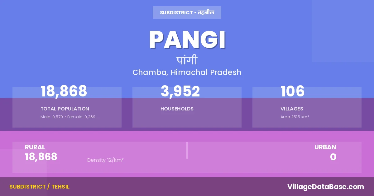
Pangi is a town and Tehsil in the Chamba district of the Himachal Pradesh. In India, a Tehsil is a subdivision of a district responsible for the administration and revenue collection of a specific area within the district. Tehsils play a crucial role in the local governance structure, contributing significantly to the development and administration of their communities.
According to the 2011 census The total area of Pangi Tehsil is 1515 km², with a population of 18868 people. The population density is 12 inhabitants per square kilometre, and there are approximately 3952 houses in the sub district.
Pangi Tehsil comprises about 106 villages. Below is a list of these villages along with information about their respective gram panchayats and the nearest town:
| # | Village Name | Gram Panchayat | Nearest Town |
|---|---|---|---|
| 1 | Ajog | Purthi | Chamba |
| 2 | Chacharwas | Karyuni Kothi | Chamba |
| 3 | Chaloli | Dharwas | Manali |
| 4 | Chasak | Sechu | Chamba |
| 5 | Chasak Bhator | Sechu | Chamba |
| 6 | Chhau | Purthi | Chamba |
| 7 | D P F Aahar | Sechu | Chamba |
| 8 | D P F Biyuseri | Sach | Chamba |
| 9 | D P F Gajrahan | Sechu | Chamba |
| 10 | D P F Kadunalah | Purthi | Chamba |
| 11 | D P F Pinchho | Sural | Manali |
| 12 | D P F Pingu | Purthi | Chamba |
| 13 | D P F Purthi | Purthi | Chamba (206 km) |
| 14 | D P F Ranu | Purthi | Chamba |
| 15 | Dhanala | Sahli | Chamba |
| 16 | Dhar Bansar | Mindhal | Chamba |
| 17 | Dhar Bhasanu | Sach | Chamba |
| 18 | Dhar Chasak Bhator | Sechu | Chamba |
| 19 | Dhar Chholagu | Shoon | Chamba |
| 20 | Dhar Chichot | Mindhal | Chamba |
| 21 | Dhar Dusgahar | Sechu | Chamba |
| 22 | Dhar Gahl | Shoon | Chamba |
| 23 | Dhar Harvi | Sechu | Chamba |
| 24 | Dhar Lunei | Purthi | Chamba |
| 25 | Dhar Panala | Purthi | Chamba |
| 26 | Dhar Parmar | Kumar | Chamba |
| 27 | Dhar Shinkal | Killar | Chamba (188 km) |
| 28 | Dhar Sidhani | Sahli | Chamba |
| 29 | Dhar Tarmpal | Purthi | Chamba |
| 30 | Dhar Thimi | Mindhal | Chamba |
| 31 | Dhar Topiyun | Shoon | Chamba |
| 32 | Dhar Udeen | Shoon | Chamba |
| 33 | Dharwas | Dharwas | Manali |
| 34 | Gahar Bindrabani | Karyas | Chamba |
| 35 | Gahar Dunei | Karyas | Chamba |
| 36 | Gawari | Kumar | Chamba |
| 37 | Ghangit | Karyas | Chamba (173 km) |
| 38 | Ghisal | Sach | Chamba |
| 39 | Hilaur | Sahli | Chamba |
| 40 | Hughal | Karyas | Chamba (176 km) |
| 41 | Hundan Bhatori | Hudan Bhatori | Chamba |
| 42 | Jhalwas | Karyas | Chamba (174 km) |
| 43 | Karel | Karel | Chamba |
| 44 | Kawas | Karel | Chamba |
| 45 | Khinan | Kumar | Chamba (199 km) |
| 46 | Kothi | Karyuni Kothi | Chamba |
| 47 | Kulal | Mindhal | Chamba |
| 48 | Kumar | Kumar | Chamba |
| 49 | Kupha | Killar | Chamba |
| 50 | Kuthah | Luj | Manali |
| 51 | Kuthal | Sach | Chamba |
| 52 | Leu | Sahli | Chamba |
| 53 | Luj | Luj | Manali |
| 54 | Mahliat | Killar | Chamba |
| 55 | Micham | Sahli | Chamba |
| 56 | Mindhal | Mindhal | Chamba |
| 57 | Mojhi | Sechu | Chamba |
| 58 | Parmar | Kumar | Chamba |
| 59 | Parmas | Killar | Chamba |
| 60 | Phindpar | Mindhal | Chamba |
| 61 | Phindru | Sach | Chamba |
| 62 | Praghwal | Karyas | Chamba |
| 63 | Pre Garaon | Karyas | Chamba |
| 64 | Punto | Karel | Chamba |
| 65 | Purthi | Purthi | Chamba |
| 66 | R F Ajog | Purthi | Chamba |
| 67 | R F Bambal | Rei | Chamba (208 km) |
| 68 | R F Chakmand | Mindhal | Chamba |
| 69 | R F Chhatwani | Killar | Chamba |
| 70 | R F Chilkot | Karel | Chamba |
| 71 | R F Kaban | Sechu | Chamba |
| 72 | R F Kagal | Mindhal | Chamba |
| 73 | R F Kalatop | Karel | Chamba |
| 74 | R F Kanyun | Dharwas | Manali |
| 75 | R F Kaslun | Mindhal | Chamba |
| 76 | R F Kulal | Mindhal | Chamba |
| 77 | R F Luj | Luj | Manali |
| 78 | R F Mojhi | Sechu | Chamba |
| 79 | R F Nildhar | Purthi | Chamba |
| 80 | R F Pilu | Sahli | Chamba |
| 81 | R F Pingu | Purthi | Chamba |
| 82 | R F Punto | Karel | Chamba |
| 83 | R F Rangi | Sach | Chamba |
| 84 | R F Saichu | Sechu | Chamba |
| 85 | R F Shour | Purthi | Chamba (204 km) |
| 86 | R F Sidh Ka Dehra | Sach | Chamba |
| 87 | R F Thandal | Purthi | Chamba |
| 88 | R F Urnu | Dharwas | Manali |
| 89 | Rani Ka Gahar | Karyas | Chamba |
| 90 | Rei | Rei | Chamba |
| 91 | Rusmas | Sural | Manali |
| 92 | Sach | Sach | Chamba |
| 93 | Sahli | Sahli | Chamba |
| 94 | Saichu | Sechu | Chamba |
| 95 | Seri | Karyuni Kothi | Chamba |
| 96 | Seri Bhatwas | Killar | Chamba |
| 97 | Shoon | Shoon | Chamba |
| 98 | Shour | Purthi | Chamba |
| 99 | Sural Bhatori | Sural | Manali |
| 100 | Tai | Sural | Manali |
| 101 | Takwas | Hudan Bhatori | Chamba |
| 102 | Thamoh | Killar | Chamba |
| 103 | Thandal | Purthi | Chamba |
| 104 | Tundru | Hudan Bhatori | Chamba |
| 105 | Tuwan | Shoon | Chamba |
| 106 | Udeen | Shoon | Chamba |
The population is distributed between urban and rural areas as follows:
| Particulars | Rural | Urban | Total |
|---|---|---|---|
| Total Population | 18868 | 0 | 18868 |
| Male Population | 9579 | 0 | 9579 |
| Female Population | 9289 | 0 | 9289 | Population Density | 12 / km² | 12 / km² |
The distribution of households in the Pangi is:
| Rural Households | Urban Households | Total Households |
|---|---|---|
| 3952 | 0 | 3952 |
Q: What is Pangi?
A: Pangi is a town and in the Chamba district of the Himachal Pradesh.
Q: What is the total area of Pangi Tehsil?
A: The total area of Pangi Tehsil is 1515 km².
Q: What is the population of Pangi Tehsil according to the 2011 census?
A: According to the 2011 census, the population of Pangi Tehsil is 18868.
Q: What is the population density of Pangi Tehsil?
A: The population density of Pangi Tehsil is 12 inhabitants per square kilometre.
Q: How many houses are there in Pangi Tehsil?
A: There are approximately 3952 houses in Pangi Tehsil.
Q: How many villages are there in Pangi Tehsil?
A: There are about 106 villages in Pangi Tehsil.
Q: Which is the largest village by population in Pangi Tehsil?
A: The largest village by population in Pangi Tehsil is Rei, with 981 people.
Q: Which is the smallest village by population in Pangi Tehsil?
A: The smallest village by population in Pangi Tehsil is D P F Aahar, with 0 people.
Q: Which is the largest village by area in Pangi Tehsil?
A: The largest village by area in Pangi Tehsil is Dhar Topiyun, with 28875 km².
Q: Which is the smallest village by area in Pangi Tehsil?
A: The smallest village by area in Pangi Tehsil is Chhau, with 11 km².
Q: What is the population distribution between urban and rural areas in Pangi Tehsil?
A: The population distribution in Pangi Tehsil is entirely rural, with a total rural population of 18868.
Q: What is the male population of Pangi Tehsil?
A: The male population of Pangi Tehsil is 9579.
Q: What is the female population of Pangi Tehsil?
A: The female population of Pangi Tehsil is 9289.
Q: How is the household distribution in Pangi Tehsil?
A: The household distribution in Pangi Tehsil is entirely rural, with a total of 3952 households.
Q: How many villages in Pangi Tehsil have a population of less than 100?
A: There are 55 villages in Pangi Tehsil with a population of less than 100.
Q: How many villages in Pangi Tehsil have a population between 100 and 499?
A: There are 40 villages in Pangi Tehsil with a population between 100 and 499.
Q: How many villages in Pangi Tehsil have a population between 500 and 999?
A: There are 11 villages in Pangi Tehsil with a population between 500 and 999.
| Total Population | Villages in Sub District Of Pangi |
|---|---|
| Less than 100 | 55 |
| 100-499 | 40 |
| 500-999 | 11 |