District → Kinnaur
State → Himachal Pradesh
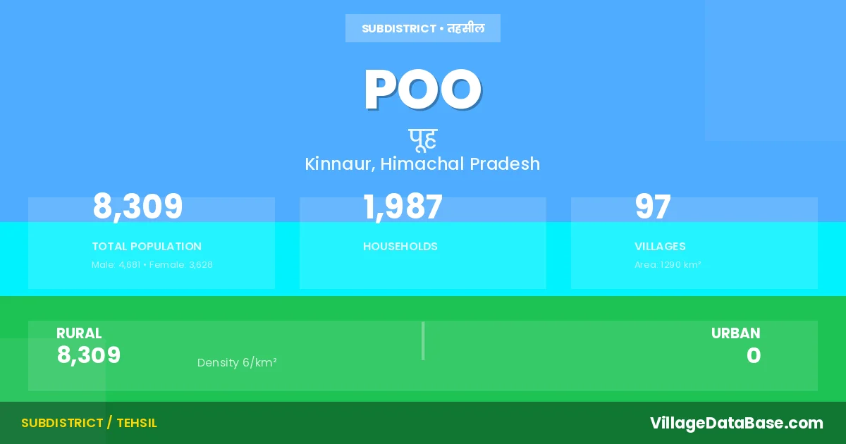
Poo is a town and Tehsil in the Kinnaur district of the Himachal Pradesh. In India, a Tehsil is a subdivision of a district responsible for the administration and revenue collection of a specific area within the district. Tehsils play a crucial role in the local governance structure, contributing significantly to the development and administration of their communities.
According to the 2011 census The total area of Poo Tehsil is 1290 km², with a population of 8309 people. The population density is 6 inhabitants per square kilometre, and there are approximately 1987 houses in the sub district.
Poo Tehsil comprises about 97 villages. Below is a list of these villages along with information about their respective gram panchayats and the nearest town:
| # | Village Name | Gram Panchayat | Nearest Town |
|---|---|---|---|
| 1 | D P F C 198 | Pooh | Rampur |
| 2 | D P F C 199 | Pooh | Rampur |
| 3 | D P F C 200 | Giabong | Rampur |
| 4 | D P F C 201 | Giabong | Rampur |
| 5 | D P F C 202 | Giabong | Rampur |
| 6 | D P F C 203 | Ropa | Rampur |
| 7 | D P F C 204 | Ropa | Rampur |
| 8 | D P F C 205 | Ropa | Rampur |
| 9 | D P F C 206 | Sunnam | Rampur |
| 10 | D P F C 207 | Sunnam | Rampur |
| 11 | D P F C 208 | Giabong | Rampur |
| 12 | D P F C 209 | Giabong | Rampur |
| 13 | D P F C 210 | Sunnam | Rampur |
| 14 | D P F C 211 | Kanam | Rampur |
| 15 | D P F C 212 | Labrang | Rampur |
| 16 | D P F C 213 | Labrang | Rampur |
| 17 | D P F C 214 | Kanam | Rampur |
| 18 | Dhar Aye | Giabong | Rampur |
| 19 | Dhar Binathang | Kanam | Rampur |
| 20 | Dhar Chamangti | Nesang | Rampur |
| 21 | Dhar Chang Guar Guar | Giabong | Rampur |
| 22 | Dhar Chho | Giabong | Rampur |
| 23 | Dhar Chhopan | Namgia | Rampur |
| 24 | Dhar Doge | Nesang | Rampur |
| 25 | Dhar Dolma | Pooh | Rampur |
| 26 | Dhar Dulse Thang | Namgia | Rampur |
| 27 | Dhar Dumba | Giabong | Rampur |
| 28 | Dhar Gyabyum | Giabong | Rampur |
| 29 | Dhar Joganchan | Nesang | Rampur |
| 30 | Dhar Khabai | Sunnam | Rampur |
| 31 | Dhar Larsa Niyowal | Giabong | Rampur |
| 32 | Dhar Lawar | Nesang | Rampur |
| 33 | Dhar Lung Kurkur | Nesang | Rampur |
| 34 | Dhar Lungpha | Nesang | Rampur |
| 35 | Dhar Mandal Gurunag | Kanam | Rampur |
| 36 | Dhar Manela | Giabong | Rampur |
| 37 | Dhar Maryul | Pooh | Rampur |
| 38 | Dhar Piwung | Nesang | Rampur |
| 39 | Dhar Potal | Namgia | Rampur |
| 40 | Dhar Rishi | Pooh | Rampur |
| 41 | Dhar Rothen | Nesang | Rampur |
| 42 | Dhar Thunsa | Pooh | Rampur |
| 43 | Dhar Tipung | Nesang | Rampur |
| 44 | Dhar Warchha | Nesang | Rampur |
| 45 | Dhar Yang Dogsa | Pooh | Rampur |
| 46 | Dhar Yangusa | Namgia | Rampur |
| 47 | Dhar Yurfuk | Pooh | Rampur |
| 48 | Dhupak | Sunnam | Rampur |
| 49 | Gyamting | Nesang | Rampur |
| 50 | Horang Pawa | Nesang | Rampur |
| 51 | Jagechan | Nesang | Rampur |
| 52 | Khadi | Nesang | Rampur |
| 53 | Mohal Bali Dhar | Pooh | Rampur |
| 54 | Nesang Khas | Nesang | Rampur |
| 55 | Piana | Nesang | Rampur |
| 56 | Shaktang | Nesang | Rampur |
| 57 | Up Mohal Brati Kanda | Giabong | Rampur |
| 58 | Up Mohal Chakulang | Pooh | Rampur |
| 59 | Up Mohal Charti | Giabong | Rampur |
| 60 | Up Mohal Chelit | Sunnam | Rampur |
| 61 | Up Mohal Chelit Kanda | Sunnam | Rampur |
| 62 | Up Mohal Dabling | Pooh | Rampur |
| 63 | Up Mohal Danmochhe | Pooh | Rampur |
| 64 | Up Mohal Doling Kanda | Pooh | Rampur |
| 65 | Up Mohal Dubling | Pooh | Rampur |
| 66 | Up Mohal Dulse Thang | Pooh | Rampur |
| 67 | Up Mohal Foche | Spillo | Rampur |
| 68 | Up Mohal Giabong Khas | Giabong | Rampur |
| 69 | Up Mohal Giabong Parla | Giabong | Rampur |
| 70 | Up Mohal Gyamil | Kanam | Rampur |
| 71 | Up Mohal Jang Phachho | Giabong | Rampur |
| 72 | Up Mohal Kanam Khas | Kanam | Rampur |
| 73 | Up Mohal Kanam Nichla | Kanam | Rampur |
| 74 | Up Mohal Khabo | Namgia | Rampur |
| 75 | Up Mohal Khad Makha | Sunnam | Rampur |
| 76 | Up Mohal Labrang | Pooh | Rampur |
| 77 | Up Mohal Labrang Khas | Labrang | Rampur |
| 78 | Up Mohal Namgia Kanda | Namgia | Rampur |
| 79 | Up Mohal Namgia Khas | Namgia | Rampur |
| 80 | Up Mohal Namkalang | Labrang | Rampur |
| 81 | Up Mohal Poo | Pooh | Rampur |
| 82 | Up Mohal Rishi Kanda | Pooh | Rampur |
| 83 | Up Mohal Rizing Kanda | Pooh | Rampur |
| 84 | Up Mohal Ropakhas | Ropa | Rampur |
| 85 | Up Mohal Rush Kulang | Giabong | Rampur |
| 86 | Up Mohal Shive | Giabong | Rampur |
| 87 | Up Mohal Shurpu | Kanam | Rampur |
| 88 | Up Mohal Shyaso | Sunnam | Rampur (144 km) |
| 89 | Up Mohal Spiloo Khas | Spillo | Rampur |
| 90 | Up Mohal Sumtat | Ropa | Rampur |
| 91 | Up Mohal Sunam Khas | Sunnam | Rampur |
| 92 | Up Mohal Taling | Giabong | Rampur |
| 93 | Up Mohal Tapang Kanda | Labrang | Rampur |
| 94 | Up Mohal Tashi Gang | Namgia | Rampur |
| 95 | Up Mohal Thoropa | Ropa | Rampur |
| 96 | Up Mohal Thunsa Kanda | Namgia | Rampur |
| 97 | Up Mohal Yangti Kanda | Pooh | Rampur |
The population is distributed between urban and rural areas as follows:
| Particulars | Rural | Urban | Total |
|---|---|---|---|
| Total Population | 8309 | 0 | 8309 |
| Male Population | 4681 | 0 | 4681 |
| Female Population | 3628 | 0 | 3628 | Population Density | 6 / km² | 6 / km² |
The distribution of households in the Poo is:
| Rural Households | Urban Households | Total Households |
|---|---|---|
| 1987 | 0 | 1987 |
Q: What is Poo?
A: Poo is a town and in the Kinnaur district of the Himachal Pradesh.
Q: What is the total area of Poo Tehsil?
A: The total area of Poo Tehsil is 1290 km².
Q: What is the population of Poo Tehsil according to the 2011 census?
A: According to the 2011 census, the population of Poo Tehsil is 8309.
Q: What is the population density of Poo Tehsil?
A: The population density of Poo Tehsil is 6 inhabitants per square kilometre.
Q: How many houses are there in Poo Tehsil?
A: There are approximately 1987 houses in Poo Tehsil.
Q: How many villages are there in Poo Tehsil?
A: There are about 97 villages in Poo Tehsil.
Q: Which is the largest village by population in Poo Tehsil?
A: The largest village by population in Poo Tehsil is Up Mohal Poo, with 2047 people.
Q: Which is the smallest village by population in Poo Tehsil?
A: The smallest village by population in Poo Tehsil is D P F C 198, with 0 people.
Q: Which is the largest village by area in Poo Tehsil?
A: The largest village by area in Poo Tehsil is Dhar Manela, with 24363 km².
Q: Which is the smallest village by area in Poo Tehsil?
A: The smallest village by area in Poo Tehsil is Dhar Chamangti, with 1 km².
Q: What is the population distribution between urban and rural areas in Poo Tehsil?
A: The population distribution in Poo Tehsil is entirely rural, with a total rural population of 8309.
Q: What is the male population of Poo Tehsil?
A: The male population of Poo Tehsil is 4681.
Q: What is the female population of Poo Tehsil?
A: The female population of Poo Tehsil is 3628.
Q: How is the household distribution in Poo Tehsil?
A: The household distribution in Poo Tehsil is entirely rural, with a total of 1987 households.
Q: How many villages in Poo Tehsil have a population of less than 100?
A: There are 80 villages in Poo Tehsil with a population of less than 100.
Q: How many villages in Poo Tehsil have a population between 100 and 499?
A: There are 12 villages in Poo Tehsil with a population between 100 and 499.
Q: How many villages in Poo Tehsil have a population between 500 and 999?
A: There are 4 villages in Poo Tehsil with a population between 500 and 999.
Q: How many villages in Poo Tehsil have a population between 2000 and 2999?
A: There is 1 village in Poo Tehsil with a population between 2000 and 2999.
| Total Population | Villages in Sub District Of Poo |
|---|---|
| Less than 100 | 80 |
| 100-499 | 12 |
| 500-999 | 4 |
| 2000-2999 | 1 |