District → Kinnaur
State → Himachal Pradesh
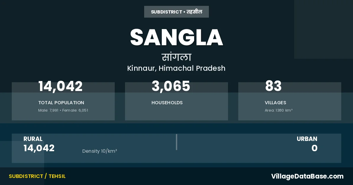
Sangla is a town and Tehsil in the Kinnaur district of the Himachal Pradesh. In India, a Tehsil is a subdivision of a district responsible for the administration and revenue collection of a specific area within the district. Tehsils play a crucial role in the local governance structure, contributing significantly to the development and administration of their communities.
According to the 2011 census The total area of Sangla Tehsil is 1380 km², with a population of 14042 people. The population density is 10 inhabitants per square kilometre, and there are approximately 3065 houses in the sub district.
Sangla Tehsil comprises about 83 villages. Below is a list of these villages along with information about their respective gram panchayats and the nearest town:
| # | Village Name | Gram Panchayat | Nearest Town |
|---|---|---|---|
| 1 | Anati Dhar | Sapni | Rampur |
| 2 | Barua Khas | Barua | Rampur |
| 3 | Batingra Dhar | Sapni | Rampur |
| 4 | Batseri | Batseri | Rampur |
| 5 | Baturi | Sapni | Rampur |
| 6 | Baturi Kanda | Sapni | Rampur |
| 7 | Boning Saring | Themgarang Boning Saring | Rampur |
| 8 | Botyaring Dhar | Sapni | Rampur |
| 9 | Bulcho Dhar | Sapni | Rampur |
| 10 | Chasu Khas | Chansu | Rampur |
| 11 | Chhitkul | Chhitkul | Rampur |
| 12 | Dewar Kanda | Sangla | Rampur |
| 13 | Dhar Arsomage | Chhitkul | Rampur |
| 14 | Dhar Bhadri | Rakchham | Rampur |
| 15 | Dhar Bhujaya | Chhitkul | Rampur |
| 16 | Dhar Bhujlang | Batseri | Rampur |
| 17 | Dhar Bujlang | Batseri | Rampur |
| 18 | Dhar Chaling Gaarh | Chhitkul | Rampur |
| 19 | Dhar Chorgaarh | Chhitkul | Rampur |
| 20 | Dhar Dambar | Chansu | Rampur |
| 21 | Dhar Damochgosha | Chhitkul | Rampur |
| 22 | Dhar Dewar | Sangla | Rampur |
| 23 | Dhar Dumti | Chhitkul | Rampur |
| 24 | Dhar Gelap | Rakchham | Rampur |
| 25 | Dhar Gire | Chhitkul | Rampur |
| 26 | Dhar Gundar | Chhitkul | Rampur |
| 27 | Dhar Hanyanichli | Batseri | Rampur |
| 28 | Dhar Hanyauperli | Batseri | Rampur |
| 29 | Dhar Hilap | Chhitkul | Rampur |
| 30 | Dhar Jowtya | Chhitkul | Rampur |
| 31 | Dhar Kali Kutang Uperli | Rakchham | Rampur |
| 32 | Dhar Kalikutang Nichli | Rakchham | Rampur |
| 33 | Dhar Kamkamphur | Rakchham | Rampur |
| 34 | Dhar Karu | Chhitkul | Rampur |
| 35 | Dhar Nakdum | Chhitkul | Rampur |
| 36 | Dhar Nakurchhe | Chhitkul | Rampur |
| 37 | Dhar Nelang | Chhitkul | Rampur |
| 38 | Dhar Nithal | Chhitkul | Rampur |
| 39 | Dhar Noshang Nichli | Rakchham | Rampur |
| 40 | Dhar Noshang Uperli | Chhitkul | Rampur |
| 41 | Dhar Noshang West | Rakchham | Rampur |
| 42 | Dhar Pashel | Shong | Rampur |
| 43 | Dhar Ranikanda | Chhitkul | Rampur |
| 44 | Dhar Rupan | Sangla | Rampur |
| 45 | Dhar Shonchayo | Chhitkul | Rampur |
| 46 | Dhar Shoshla | Rakchham | Rampur |
| 47 | Dhar Shothang | Chhitkul | Rampur |
| 48 | Dhar Singan | Batseri | Rampur |
| 49 | Dhar Tawla | Rakchham | Rampur |
| 50 | Dhar Thanda Pani | Chhitkul | Rampur |
| 51 | Dhar Vaspa | Chhitkul | Rampur |
| 52 | Dhar Wadang | Kamru | Rampur |
| 53 | Goroden | Kamru | Rampur |
| 54 | Gunthar | Sapni | Rampur |
| 55 | Jareyo | Chansu | Rampur |
| 56 | Kamru Khas | Kamru | Rampur |
| 57 | Kanahi Khas | Sapni | Rampur |
| 58 | Kharogla | Rakchham | Rampur |
| 59 | Kilba Khas | Kilba | Rampur |
| 60 | Kupa | Kamru | Rampur |
| 61 | Lachonden | Kamru | Rampur |
| 62 | Limoden | Chansu | Rampur |
| 63 | Mastrang | Chhitkul | Rampur |
| 64 | Mone Rang | Barua | Rampur |
| 65 | Nagassaring | Barua | Rampur |
| 66 | Nyardeem | Kilba | Rampur |
| 67 | Panpo Kanda | Themgarang Boning Saring | Rampur |
| 68 | Patyo | Sapni | Rampur |
| 69 | Pilacho Dhar | Sapni | Rampur |
| 70 | Rakchham | Rakchham | Rampur |
| 71 | Regsthang | Kamru | Rampur |
| 72 | Sangla | Sangla | Rampur |
| 73 | Sangla Kanda | Sangla | Rampur |
| 74 | Sapni Khas | Sapni | Rampur |
| 75 | Seringche | Batseri | Rampur |
| 76 | Shaung Khas | Shong | Rampur |
| 77 | Shenan Den | Sapni | Rampur |
| 78 | Shobre Yanang | Shong | Rampur |
| 79 | Supitang Dhar | Sapni | Rampur |
| 80 | Tesha Guden | Shong | Rampur |
| 81 | Thapa Saring | Sangla | Rampur |
| 82 | Thikru | Kilba | Rampur |
| 83 | Tilchakhula Dhar | Sapni | Rampur |
The population is distributed between urban and rural areas as follows:
| Particulars | Rural | Urban | Total |
|---|---|---|---|
| Total Population | 14042 | 0 | 14042 |
| Male Population | 7991 | 0 | 7991 |
| Female Population | 6051 | 0 | 6051 | Population Density | 10 / km² | 10 / km² |
The distribution of households in the Sangla is:
| Rural Households | Urban Households | Total Households |
|---|---|---|
| 3065 | 0 | 3065 |
Q: What is Sangla?
A: Sangla is a town and in the Kinnaur district of the Himachal Pradesh.
Q: What is the total area of Sangla Tehsil?
A: The total area of Sangla Tehsil is 1380 km².
Q: What is the population of Sangla Tehsil according to the 2011 census?
A: According to the 2011 census, the population of Sangla Tehsil is 14042.
Q: What is the population density of Sangla Tehsil?
A: The population density of Sangla Tehsil is 10 inhabitants per square kilometre.
Q: How many houses are there in Sangla Tehsil?
A: There are approximately 3065 houses in Sangla Tehsil.
Q: How many villages are there in Sangla Tehsil?
A: There are about 83 villages in Sangla Tehsil.
Q: Which is the largest village by population in Sangla Tehsil?
A: The largest village by population in Sangla Tehsil is Sangla, with 2244 people.
Q: Which is the smallest village by population in Sangla Tehsil?
A: The smallest village by population in Sangla Tehsil is Anati Dhar, with 0 people.
Q: Which is the largest village by area in Sangla Tehsil?
A: The largest village by area in Sangla Tehsil is Dhar Ranikanda, with 8668 km².
Q: Which is the smallest village by area in Sangla Tehsil?
A: The smallest village by area in Sangla Tehsil is Dhar Noshang West, with 30 km².
Q: What is the population distribution between urban and rural areas in Sangla Tehsil?
A: The population distribution in Sangla Tehsil is entirely rural, with a total rural population of 14042.
Q: What is the male population of Sangla Tehsil?
A: The male population of Sangla Tehsil is 7991.
Q: What is the female population of Sangla Tehsil?
A: The female population of Sangla Tehsil is 6051.
Q: How is the household distribution in Sangla Tehsil?
A: The household distribution in Sangla Tehsil is entirely rural, with a total of 3065 households.
Q: How many villages in Sangla Tehsil have a population of less than 100?
A: There are 61 villages in Sangla Tehsil with a population of less than 100.
Q: How many villages in Sangla Tehsil have a population between 100 and 499?
A: There are 9 villages in Sangla Tehsil with a population between 100 and 499.
Q: How many villages in Sangla Tehsil have a population between 500 and 999?
A: There are 10 villages in Sangla Tehsil with a population between 500 and 999.
Q: How many villages in Sangla Tehsil have a population between 1000 and 1999?
A: There are 2 villages in Sangla Tehsil with a population between 1000 and 1999.
Q: How many villages in Sangla Tehsil have a population between 2000 and 2999?
A: There is 1 village in Sangla Tehsil with a population between 2000 and 2999.
| Total Population | Villages in Sub District Of Sangla |
|---|---|
| Less than 100 | 61 |
| 100-499 | 9 |
| 500-999 | 10 |
| 1000-1999 | 2 |
| 2000-2999 | 1 |